Floyd Topo Map Arkansas
To zoom in, hover over the map of Floyd
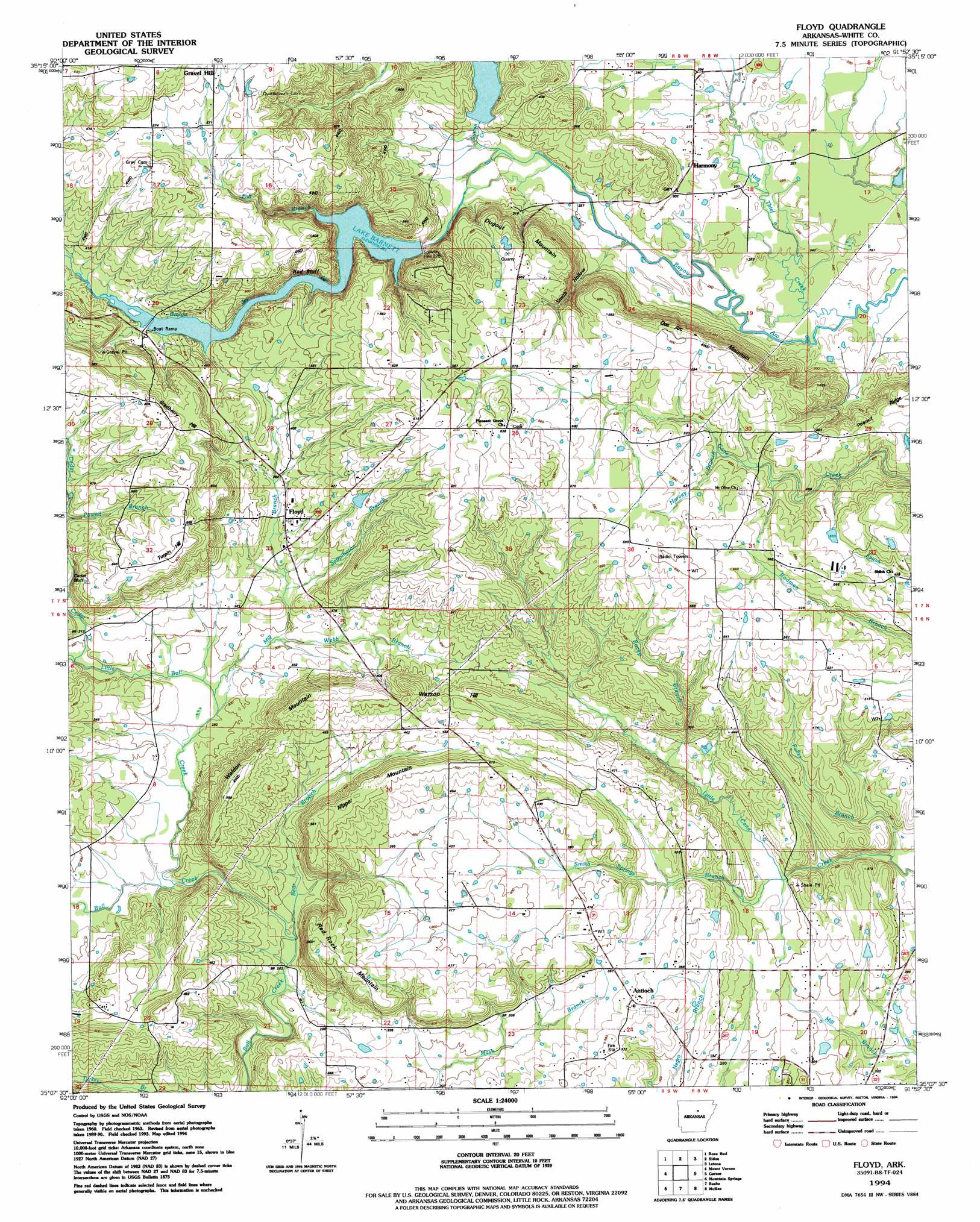
USGS Topo Quad 35091b8 - 1:24,000 scale
| Topo Map Name: | Floyd |
| USGS Topo Quad ID: | 35091b8 |
| Print Size: | ca. 21 1/4" wide x 27" high |
| Southeast Coordinates: | 35.125° N latitude / 91.875° W longitude |
| Map Center Coordinates: | 35.1875° N latitude / 91.9375° W longitude |
| U.S. State: | AR |
| Filename: | o35091b8.jpg |
| Download Map JPG Image: | Floyd topo map 1:24,000 scale |
| Map Type: | Topographic |
| Topo Series: | 7.5´ |
| Map Scale: | 1:24,000 |
| Source of Map Images: | United States Geological Survey (USGS) |
| Alternate Map Versions: |
Floyd AR 1963, updated 1964 Download PDF Buy paper map Floyd AR 1963, updated 1984 Download PDF Buy paper map Floyd AR 1963, updated 1985 Download PDF Buy paper map Floyd AR 1994, updated 1994 Download PDF Buy paper map Floyd AR 2011 Download PDF Buy paper map Floyd AR 2014 Download PDF Buy paper map |
1:24,000 Topo Quads surrounding Floyd
Quitman |
Heber Springs |
West Pangburn |
Pangburn |
Steprock |
Barney |
Rose Bud |
Sidon |
Letona |
Judsonia |
Enola |
Mount Vernon |
Floyd |
Garner |
Kensett |
Vilonia |
Mountain Springs |
Beebe |
Mcrae |
Walker |
Olmstead |
Cabot |
Oak Grove |
Wattensaw |
Hickory Plains |
> Back to 35091a1 at 1:100,000 scale
> Back to 35090a1 at 1:250,000 scale
> Back to U.S. Topo Maps home
Floyd topo map: Gazetteer
Floyd: Cliffs
Cedar Bluff elevation 118m 387′Red Bluff elevation 130m 426′
Floyd: Dams
Lercher Lake Number Two Dam elevation 155m 508′Floyd: Mines
Floyd Quarry elevation 171m 561′Floyd: Populated Places
Antioch elevation 117m 383′Brundige (historical) elevation 174m 570′
Essex elevation 78m 255′
Floyd elevation 112m 367′
Harmony elevation 88m 288′
Sunrise (historical) elevation 87m 285′
Floyd: Reservoirs
Lercher Lake Number Two elevation 155m 508′Floyd: Streams
Bear Branch elevation 78m 255′Cedar Creek elevation 94m 308′
Fall Branch elevation 110m 360′
Fuller Branch elevation 77m 252′
Harvey Branch elevation 148m 485′
Hog Thief Creek elevation 71m 232′
Little Bull Creek elevation 80m 262′
Mill Branch elevation 87m 285′
Rocky Branch elevation 96m 314′
Sappington Branch elevation 98m 321′
Smith Springs Branch elevation 84m 275′
Sutton Creek elevation 79m 259′
Webb Branch elevation 91m 298′
Floyd: Summits
Bradberry Hill elevation 193m 633′Des Arc Mountain elevation 192m 629′
Dugout Mountain elevation 192m 629′
Nipper Mountain elevation 169m 554′
Red Rock Mountain elevation 167m 547′
Turpin Hill elevation 190m 623′
Waldon Mountain elevation 180m 590′
Watson Hill elevation 172m 564′
Floyd: Valleys
Smith Hollow elevation 78m 255′Floyd digital topo map on disk
Buy this Floyd topo map showing relief, roads, GPS coordinates and other geographical features, as a high-resolution digital map file on DVD: