Morganton Topo Map Arkansas
To zoom in, hover over the map of Morganton
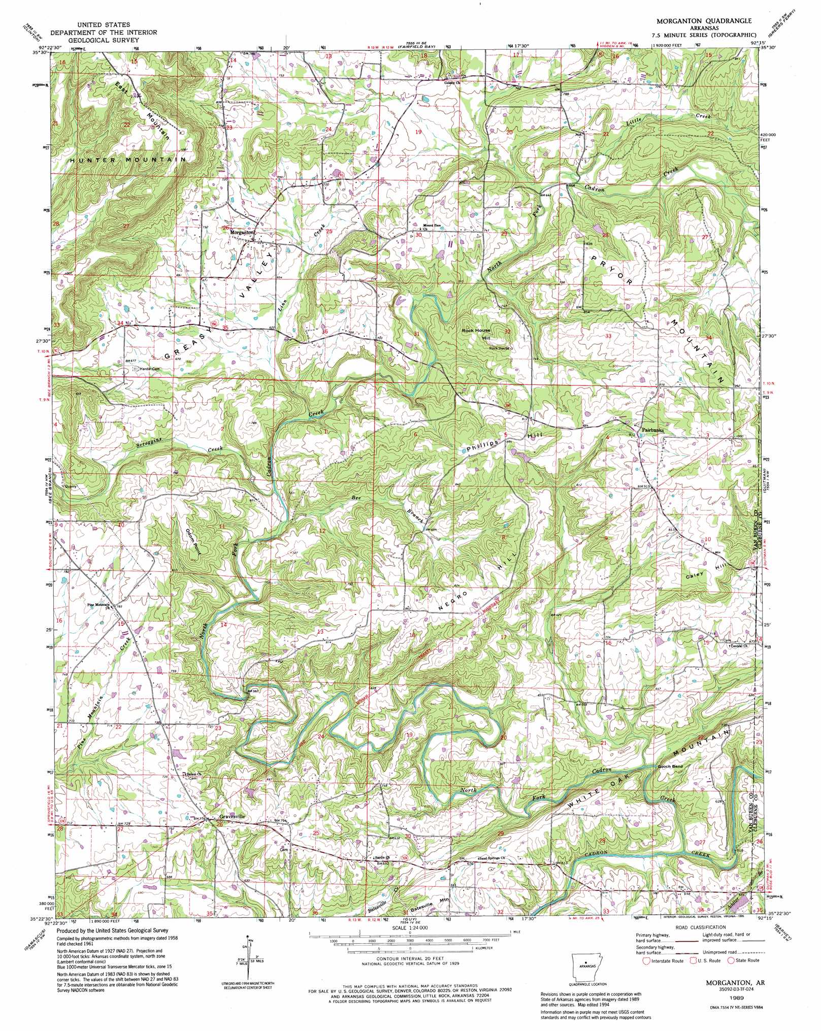
USGS Topo Quad 35092d3 - 1:24,000 scale
| Topo Map Name: | Morganton |
| USGS Topo Quad ID: | 35092d3 |
| Print Size: | ca. 21 1/4" wide x 27" high |
| Southeast Coordinates: | 35.375° N latitude / 92.25° W longitude |
| Map Center Coordinates: | 35.4375° N latitude / 92.3125° W longitude |
| U.S. State: | AR |
| Filename: | o35092d3.jpg |
| Download Map JPG Image: | Morganton topo map 1:24,000 scale |
| Map Type: | Topographic |
| Topo Series: | 7.5´ |
| Map Scale: | 1:24,000 |
| Source of Map Images: | United States Geological Survey (USGS) |
| Alternate Map Versions: |
Morganton AR 1961, updated 1966 Download PDF Buy paper map Morganton AR 1961, updated 1976 Download PDF Buy paper map Morganton AR 1989, updated 1995 Download PDF Buy paper map Morganton AR 2011 Download PDF Buy paper map Morganton AR 2014 Download PDF Buy paper map |
1:24,000 Topo Quads surrounding Morganton
Botkinburg |
Old Lexington |
Shirley |
Parma |
Prim |
Scotland |
Clinton |
Fairfield Bay |
Greers Ferry |
Brownsville |
Formosa |
Bee Branch |
Morganton |
Quitman |
Heber Springs |
Springfield |
Damascus |
Guy |
Barney |
Rose Bud |
Menifee |
Greenbrier |
Holland |
Enola |
Mount Vernon |
> Back to 35092a1 at 1:100,000 scale
> Back to 35092a1 at 1:250,000 scale
> Back to U.S. Topo Maps home
Morganton topo map: Gazetteer
Morganton: Bends
Gooch Bend elevation 161m 528′Morganton: Pillars
Rock House elevation 238m 780′Morganton: Populated Places
Fairbanks elevation 267m 875′Gravesville elevation 236m 774′
Morganton elevation 216m 708′
Sulphur Springs elevation 223m 731′
Morganton: Post Offices
Morganton Post Office (historical) elevation 217m 711′Morganton: Streams
Addler Branch elevation 160m 524′Bee Branch elevation 179m 587′
Linn Creek elevation 197m 646′
Little Creek elevation 193m 633′
North Fork Cadron Creek elevation 158m 518′
Scroggins Creek elevation 180m 590′
Morganton: Summits
Caley Hill elevation 272m 892′East Mountain elevation 346m 1135′
Negro Hill elevation 250m 820′
Odom Point elevation 249m 816′
Phillips Hill elevation 275m 902′
Rock House Hill elevation 262m 859′
White Oak Mountain elevation 218m 715′
Morganton: Valleys
Greasy Valley elevation 202m 662′Morganton digital topo map on disk
Buy this Morganton topo map showing relief, roads, GPS coordinates and other geographical features, as a high-resolution digital map file on DVD: