Shirley Topo Map Arkansas
To zoom in, hover over the map of Shirley
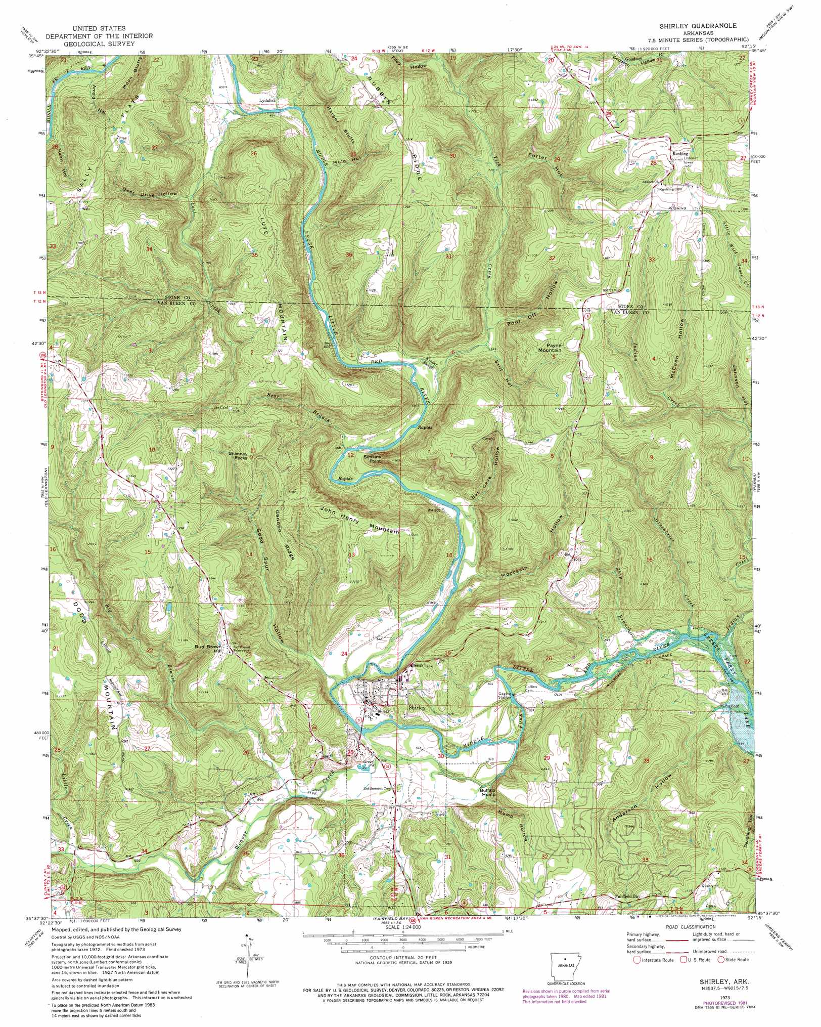
USGS Topo Quad 35092f3 - 1:24,000 scale
| Topo Map Name: | Shirley |
| USGS Topo Quad ID: | 35092f3 |
| Print Size: | ca. 21 1/4" wide x 27" high |
| Southeast Coordinates: | 35.625° N latitude / 92.25° W longitude |
| Map Center Coordinates: | 35.6875° N latitude / 92.3125° W longitude |
| U.S. State: | AR |
| Filename: | o35092f3.jpg |
| Download Map JPG Image: | Shirley topo map 1:24,000 scale |
| Map Type: | Topographic |
| Topo Series: | 7.5´ |
| Map Scale: | 1:24,000 |
| Source of Map Images: | United States Geological Survey (USGS) |
| Alternate Map Versions: |
Shirley AR 1973, updated 1975 Download PDF Buy paper map Shirley AR 1973, updated 1982 Download PDF Buy paper map Shirley AR 1973, updated 1982 Download PDF Buy paper map Shirley AR 1976, updated 1977 Download PDF Buy paper map Shirley AR 2011 Download PDF Buy paper map Shirley AR 2014 Download PDF Buy paper map |
1:24,000 Topo Quads surrounding Shirley
Harriet |
Landis |
Onia |
Fiftysix |
Sylamore |
Leslie |
Oxley |
Fox |
Mountain View Sw |
Mountain View |
Botkinburg |
Old Lexington |
Shirley |
Parma |
Prim |
Scotland |
Clinton |
Fairfield Bay |
Greers Ferry |
Brownsville |
Formosa |
Bee Branch |
Morganton |
Quitman |
Heber Springs |
> Back to 35092e1 at 1:100,000 scale
> Back to 35092a1 at 1:250,000 scale
> Back to U.S. Topo Maps home
Shirley topo map: Gazetteer
Shirley: Bays
Fairfield Bay elevation 317m 1040′Shirley: Cliffs
Buffalo Hump elevation 239m 784′Harper Bluffs elevation 265m 869′
Moon Bluffs elevation 305m 1000′
Shirley: Flats
Sally Flats elevation 397m 1302′Shirley: Pillars
Chimney Rocks elevation 357m 1171′Shirley: Populated Places
Lydalisk elevation 196m 643′Pekin (historical) elevation 416m 1364′
Poe (historical) elevation 150m 492′
Rushing elevation 425m 1394′
Settlement (historical) elevation 158m 518′
Shirley elevation 163m 534′
Shirley: Ridges
Gannon Ridge elevation 351m 1151′Nubbin Ridge elevation 405m 1328′
Shirley: Streams
Bear Branch elevation 170m 557′Greenbrier Creek elevation 141m 462′
Indian Creek elevation 152m 498′
Kinder Slough elevation 175m 574′
Little Creek elevation 202m 662′
Lost Creek elevation 195m 639′
Ship Branch elevation 145m 475′
Tick Creek elevation 173m 567′
Weaver Creek elevation 148m 485′
Shirley: Summits
Bud Brown Hill elevation 342m 1122′Dodd Mountain elevation 413m 1354′
John Henry Mountain elevation 384m 1259′
Lute Mountain elevation 357m 1171′
Payne Mountain elevation 404m 1325′
Simkins Point elevation 249m 816′
Shirley: Valleys
Anderson Hollow elevation 145m 475′Arnold Hollow elevation 203m 666′
Bat Cave Hollow elevation 166m 544′
Deer Drive Hollow elevation 213m 698′
Files Hollow elevation 253m 830′
Good Spur Hollow elevation 155m 508′
Harris Hollow elevation 221m 725′
Hump Hollow elevation 154m 505′
Johnson Hollow elevation 232m 761′
McCann Hollow elevation 269m 882′
Moccasin Hollow elevation 162m 531′
Mule Hollow elevation 186m 610′
Porter Hollow elevation 219m 718′
Pour Off Hollow elevation 190m 623′
Still Hollow elevation 186m 610′
Shirley digital topo map on disk
Buy this Shirley topo map showing relief, roads, GPS coordinates and other geographical features, as a high-resolution digital map file on DVD: