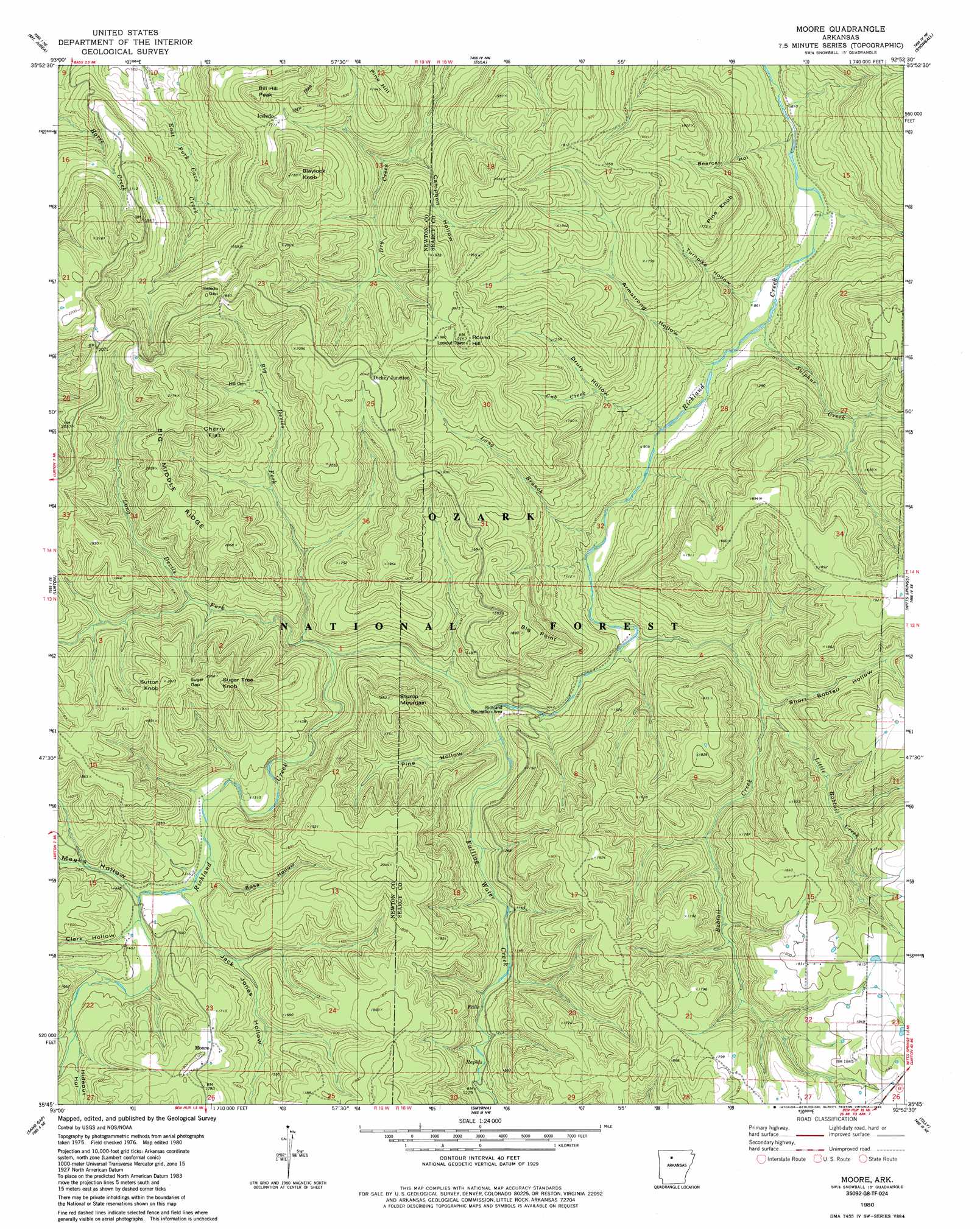
Moore Topo Map Arkansas
To zoom in, hover over the map of Moore
USGS Topo Quad 35092g8 - 1:24,000 scale
| Topo Map Name: | Moore |
| USGS Topo Quad ID: | 35092g8 |
| Print Size: | ca. 21 1/4" wide x 27" high |
| Southeast Coordinates: | 35.75° N latitude / 92.875° W longitude |
| Map Center Coordinates: | 35.8125° N latitude / 92.9375° W longitude |
| U.S. State: | AR |
| Filename: | o35092g8.jpg |
| Download Map JPG Image: | Moore topo map 1:24,000 scale |
| Map Type: | Topographic |
| Topo Series: | 7.5´ |
| Map Scale: | 1:24,000 |
| Source of Map Images: | United States Geological Survey (USGS) |
| Alternate Map Versions: |
Snowball SW AR 1974, updated 1975 Download PDF Buy paper map Moore AR 1980, updated 1980 Download PDF Buy paper map Moore AR 1980, updated 1986 Download PDF Buy paper map Moore AR 2011 Download PDF Buy paper map Moore AR 2014 Download PDF Buy paper map |
| FStopo: | US Forest Service topo Moore is available: Download FStopo PDF Download FStopo TIF |
1:24,000 Topo Quads surrounding Moore
Jasper |
Hasty |
Western Grove |
Saint Joe |
Maumee |
Parthenon |
Mount Judea |
Eula |
Snowball |
Marshall |
Deer |
Lurton |
Moore |
Witts Spring |
Canaan |
Fort Douglas |
Sand Gap |
Smyrna |
Tilly |
Alread |
Treat |
Simpson |
Solo |
Lost Corner |
Rex |
> Back to 35092e1 at 1:100,000 scale
> Back to 35092a1 at 1:250,000 scale
> Back to U.S. Topo Maps home
Moore topo map: Gazetteer
Moore: Benches
Taylor Bench elevation 482m 1581′Moore: Flats
Cherry Flat elevation 557m 1827′Moore: Gaps
Iceledo Gap elevation 509m 1669′Sugar Gap elevation 556m 1824′
Moore: Parks
Richland Recreation Area elevation 315m 1033′Moore: Populated Places
Dickey Junction elevation 616m 2020′Leigo (historical) elevation 651m 2135′
Moore elevation 536m 1758′
Moore: Ridges
Big Middle Ridge elevation 617m 2024′Moore: Streams
Big Devils Fork elevation 381m 1250′Bobtail Creek elevation 289m 948′
Cub Creek elevation 452m 1482′
Falling Water Creek elevation 312m 1023′
Little Bobtail Creek elevation 358m 1174′
Long Branch elevation 279m 915′
Long Devils Fork elevation 365m 1197′
Sulphur Creek elevation 255m 836′
Moore: Summits
Big Point elevation 565m 1853′Bill Hill Peak elevation 569m 1866′
Blaylock Knob elevation 620m 2034′
Pine Hill elevation 552m 1811′
Pine Knob elevation 522m 1712′
Round Hill elevation 649m 2129′
Stump Mountain elevation 540m 1771′
Sugar Tree Knob elevation 597m 1958′
Sutton Knob elevation 610m 2001′
Moore: Trails
Hideout Trail elevation 451m 1479′Moore: Valleys
Armstrong Hollow elevation 264m 866′Bearcat Hollow elevation 239m 784′
Bearcat Hollow elevation 241m 790′
Campbell Hollow elevation 399m 1309′
Clark Hollow elevation 408m 1338′
Drury Hollow elevation 272m 892′
Hideout Hollow elevation 438m 1437′
Jack Jones Hollow elevation 407m 1335′
Meeks Hollow elevation 405m 1328′
Meeks Hollow elevation 403m 1322′
Pine Hollow elevation 343m 1125′
Rose Hollow elevation 396m 1299′
Short Bobtail Hollow elevation 356m 1167′
Short Bobtail Hollow elevation 348m 1141′
Turnpike Hollow elevation 256m 839′
Moore digital topo map on disk
Buy this Moore topo map showing relief, roads, GPS coordinates and other geographical features, as a high-resolution digital map file on DVD: