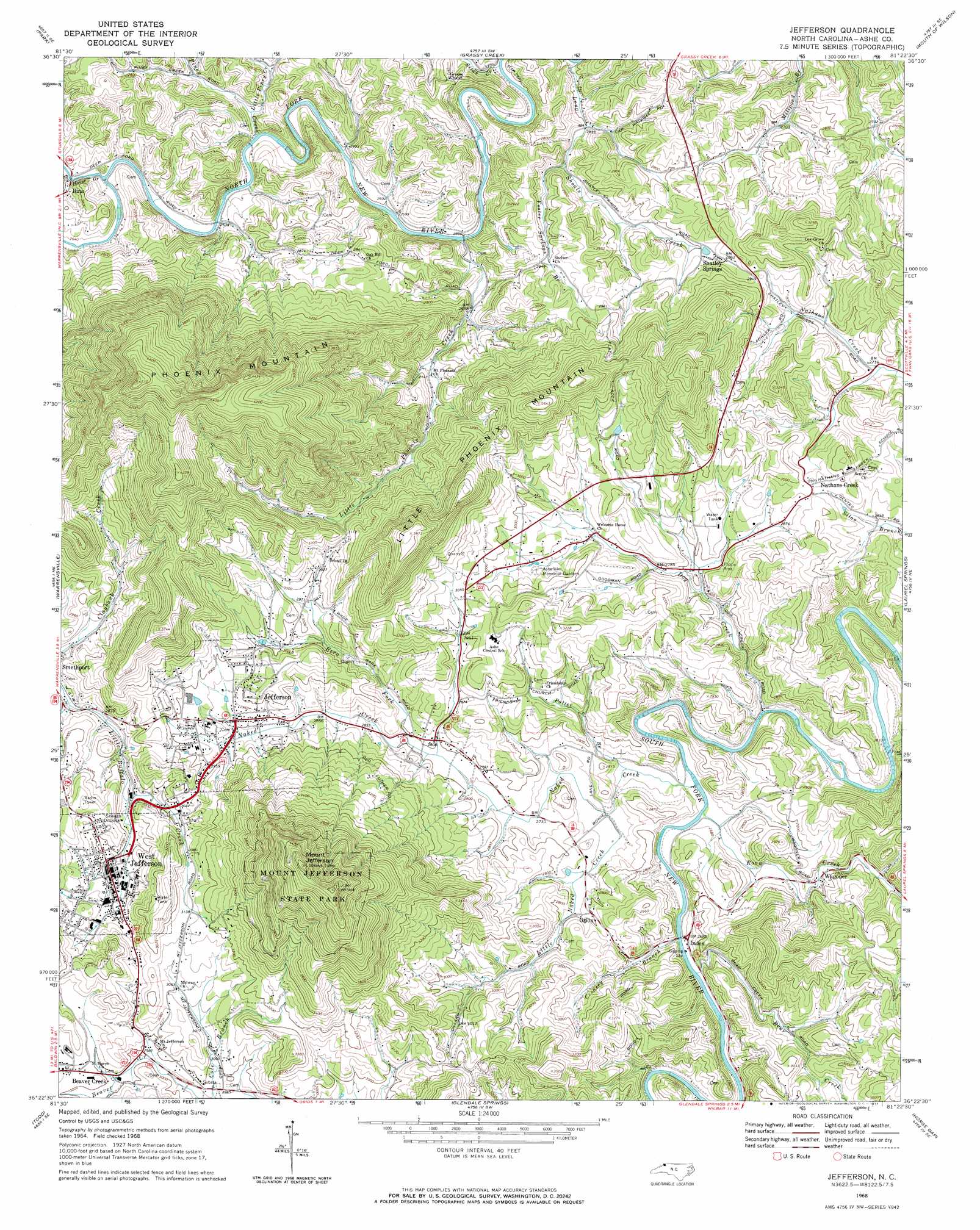
Jefferson Topo Map North Carolina
To zoom in, hover over the map of Jefferson
USGS Topo Quad 36081d4 - 1:24,000 scale
| Topo Map Name: | Jefferson |
| USGS Topo Quad ID: | 36081d4 |
| Print Size: | ca. 21 1/4" wide x 27" high |
| Southeast Coordinates: | 36.375° N latitude / 81.375° W longitude |
| Map Center Coordinates: | 36.4375° N latitude / 81.4375° W longitude |
| U.S. State: | NC |
| Filename: | o36081d4.jpg |
| Download Map JPG Image: | Jefferson topo map 1:24,000 scale |
| Map Type: | Topographic |
| Topo Series: | 7.5´ |
| Map Scale: | 1:24,000 |
| Source of Map Images: | United States Geological Survey (USGS) |
| Alternate Map Versions: |
Jefferson NC 1968, updated 1971 Download PDF Buy paper map Jefferson NC 1998, updated 1999 Download PDF Buy paper map Jefferson NC 2010 Download PDF Buy paper map Jefferson NC 2013 Download PDF Buy paper map Jefferson NC 2016 Download PDF Buy paper map |
1:24,000 Topo Quads surrounding Jefferson
Konnarock |
Whitetop Mountain |
Trout Dale |
Middle Fox Creek |
Elk Creek |
Grayson |
Park |
Grassy Creek |
Mouth Of Wilson |
Sparta West |
Baldwin Gap |
Warrensville |
Jefferson |
Laurel Springs |
Whitehead |
Zionville |
Todd |
Glendale Springs |
Horse Gap |
Mcgrady |
Boone |
Deep Gap |
Maple Springs |
Purlear |
Wilkesboro |
> Back to 36081a1 at 1:100,000 scale
> Back to 36080a1 at 1:250,000 scale
> Back to U.S. Topo Maps home
Jefferson topo map: Gazetteer
Jefferson: Airports
Ashe County Airport elevation 946m 3103′Jefferson: Parks
Mount Jefferson State Park elevation 1384m 4540′New River State Park elevation 824m 2703′
Jefferson: Populated Places
Bina elevation 818m 2683′Jefferson elevation 890m 2919′
Nathans Creek elevation 908m 2979′
Orion elevation 853m 2798′
Shatley Springs elevation 864m 2834′
Wagoner elevation 838m 2749′
West Jefferson elevation 907m 2975′
Jefferson: Streams
Bear Creek elevation 813m 2667′Big Horse Creek elevation 802m 2631′
Big Horse Creek elevation 801m 2627′
Creasey Branch elevation 815m 2673′
Dog Creek elevation 802m 2631′
Ezra Fork elevation 850m 2788′
Foster Springs Branch elevation 805m 2641′
Little Naked Creek elevation 818m 2683′
Little Phoenix Creek elevation 792m 2598′
Little Piney Creek elevation 802m 2631′
Long Shoals Creek elevation 804m 2637′
Naked Creek elevation 807m 2647′
Piney Creek elevation 797m 2614′
Potter Branch elevation 814m 2670′
Roan Creek elevation 809m 2654′
Silas Creek elevation 784m 2572′
Jefferson: Summits
Little Phoenix Mountain elevation 1171m 3841′Mount Jefferson elevation 1406m 4612′
Phoenix Mountain elevation 1430m 4691′
Jefferson digital topo map on disk
Buy this Jefferson topo map showing relief, roads, GPS coordinates and other geographical features, as a high-resolution digital map file on DVD:
Western Virginia & Southern West Virginia
Buy digital topo maps: Western Virginia & Southern West Virginia