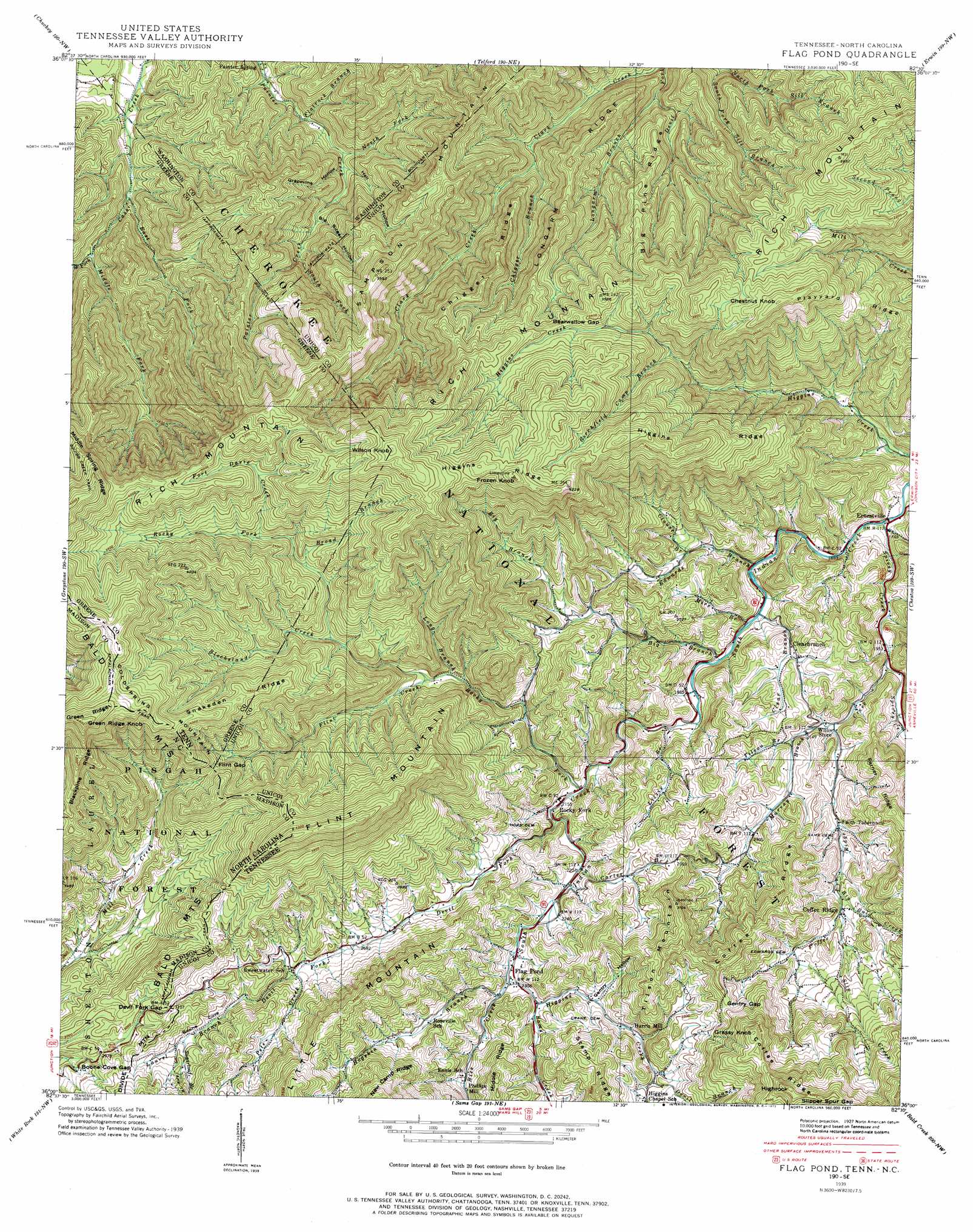
Flag Pond Topo Map Tennessee
To zoom in, hover over the map of Flag Pond
USGS Topo Quad 36082a5 - 1:24,000 scale
| Topo Map Name: | Flag Pond |
| USGS Topo Quad ID: | 36082a5 |
| Print Size: | ca. 21 1/4" wide x 27" high |
| Southeast Coordinates: | 36° N latitude / 82.5° W longitude |
| Map Center Coordinates: | 36.0625° N latitude / 82.5625° W longitude |
| U.S. States: | TN, NC |
| Filename: | o36082a5.jpg |
| Download Map JPG Image: | Flag Pond topo map 1:24,000 scale |
| Map Type: | Topographic |
| Topo Series: | 7.5´ |
| Map Scale: | 1:24,000 |
| Source of Map Images: | United States Geological Survey (USGS) |
| Alternate Map Versions: |
Flag Pond TN 1936 Download PDF Buy paper map Flag Pond TN 1939 Download PDF Buy paper map Flag Pond TN 1939, updated 1954 Download PDF Buy paper map Flag Pond TN 1939, updated 1972 Download PDF Buy paper map Flag Pond TN 2003, updated 2004 Download PDF Buy paper map Flag Pond TN 2011 Download PDF Buy paper map Flag Pond TN 2013 Download PDF Buy paper map Flag Pond TN 2016 Download PDF Buy paper map |
| FStopo: | US Forest Service topo Flag Pond is available: Download FStopo PDF Download FStopo TIF |
1:24,000 Topo Quads surrounding Flag Pond
Baileyton |
Jearoldstown |
Leesburg |
Jonesboro |
Johnson City |
Greeneville |
Chuckey |
Telford |
Erwin |
Unicoi |
Davy Crockett Lake |
Greystone |
Flag Pond |
Chestoa |
Huntdale |
Hot Springs |
White Rock |
Sams Gap |
Bald Creek |
Burnsville |
Spring Creek |
Marshall |
Mars Hill |
Barnardsville |
Mount Mitchell |
> Back to 36082a1 at 1:100,000 scale
> Back to 36082a1 at 1:250,000 scale
> Back to U.S. Topo Maps home
Flag Pond topo map: Gazetteer
Flag Pond: Falls
Buckeye Falls elevation 913m 2995′Flag Pond: Gaps
Beanwallow Gap elevation 987m 3238′Boone Cove Gap elevation 943m 3093′
Boone Cove Gap elevation 943m 3093′
Devil Fork Gap elevation 947m 3106′
Devil Fork Gap elevation 949m 3113′
Flint Gap elevation 1053m 3454′
Gentry Gap elevation 960m 3149′
Mink Gap elevation 1202m 3943′
Slipper Spur Gap elevation 1187m 3894′
Slipper Spur Gap elevation 1197m 3927′
Flag Pond: Populated Places
Briggs (historical) elevation 836m 2742′Clearbranch elevation 678m 2224′
Coffee Ridge elevation 750m 2460′
Ernestville elevation 564m 1850′
Flag Pond elevation 705m 2312′
Harris Mill elevation 761m 2496′
Loganton (historical) elevation 605m 1984′
Painter Spring elevation 513m 1683′
Rocky Fork elevation 648m 2125′
Flag Pond: Ridges
Big Pine Ridge elevation 904m 2965′Chigger Ridge elevation 936m 3070′
Coffee Ridge elevation 991m 3251′
Higgins Ridge elevation 1189m 3900′
Higgins Ridge elevation 1298m 4258′
Little Mountain elevation 1048m 3438′
Locust Ridge elevation 1044m 3425′
Longarm Ridge elevation 828m 2716′
Playyard Ridge elevation 957m 3139′
Rich Mountain elevation 1184m 3884′
Snakeden Ridge elevation 1189m 3900′
Flag Pond: Streams
Big Bald Creek elevation 706m 2316′Big Branch elevation 595m 1952′
Birchfield Camp Branch elevation 872m 2860′
Blockstand Creek elevation 863m 2831′
Broad Branch elevation 934m 3064′
Carter Branch elevation 667m 2188′
Chigger Branch elevation 612m 2007′
Clear Branch elevation 594m 1948′
Clouse Branch elevation 668m 2191′
Coffee Ridge Creek elevation 591m 1938′
Devil Branch elevation 847m 2778′
Devil Fork elevation 649m 2129′
Devils Branch elevation 779m 2555′
East Fork Cassi Creek elevation 565m 1853′
East Fork Higgins Creek elevation 780m 2559′
Edwards Branch elevation 584m 1916′
Flatrock Branch elevation 543m 1781′
Flint Creek elevation 778m 2552′
Fort Davie Creek elevation 988m 3241′
Gilbert Branch elevation 562m 1843′
Higgins Creek elevation 696m 2283′
Hogskin Branch elevation 701m 2299′
Laurel Branch elevation 859m 2818′
Lizzie Branch elevation 609m 1998′
Long Branch elevation 770m 2526′
Longarm Branch elevation 560m 1837′
Middle Fork Cassi Creek elevation 602m 1975′
Mire Branch elevation 593m 1945′
Murray Branch elevation 629m 2063′
North Fork Painter Creek elevation 566m 1856′
Pete Creek elevation 826m 2709′
Rice Creek elevation 696m 2283′
Rocky Fork elevation 639m 2096′
Sams Creek elevation 706m 2316′
Slip Creek elevation 755m 2477′
South Fork Painter Creek elevation 694m 2276′
Spivey Creek elevation 561m 1840′
Sugarloaf Branch elevation 897m 2942′
Tilson Branch elevation 662m 2171′
West Fork Cassi Creek elevation 636m 2086′
Flag Pond: Summits
Chestnut Knob elevation 1209m 3966′Coldspring Mountain elevation 1199m 3933′
Flint Mountain elevation 1327m 4353′
Flint Mountain elevation 1331m 4366′
Frozen Knob elevation 1338m 4389′
Grassy Knob elevation 1146m 3759′
Green Ridge Knob elevation 1480m 4855′
Highrock elevation 1244m 4081′
Sampson Mountain elevation 1112m 3648′
Tilson Mountain elevation 993m 3257′
Wilson Knob elevation 1396m 4580′
Flag Pond: Trails
Clark Creek Trail elevation 681m 2234′Flag Pond: Valleys
Big Sugar Hollow elevation 630m 2066′Boone Cove elevation 859m 2818′
Gentry Hollow elevation 735m 2411′
Grapevine Hollow elevation 577m 1893′
Hell Hollow elevation 577m 1893′
Flag Pond digital topo map on disk
Buy this Flag Pond topo map showing relief, roads, GPS coordinates and other geographical features, as a high-resolution digital map file on DVD:
Western Virginia & Southern West Virginia
Buy digital topo maps: Western Virginia & Southern West Virginia