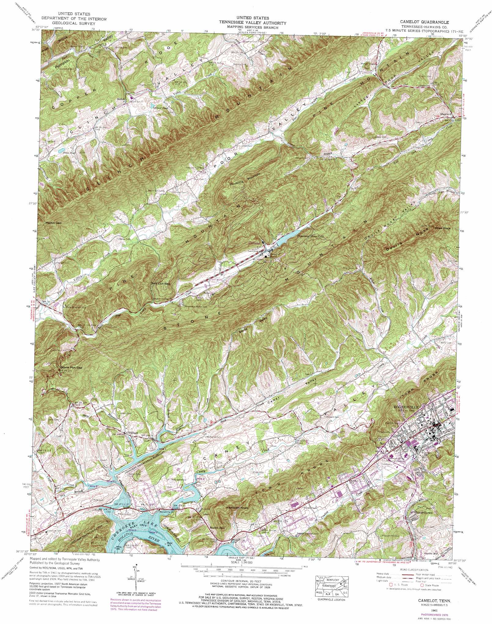
Camelot Topo Map Tennessee
To zoom in, hover over the map of Camelot
USGS Topo Quad 36083d1 - 1:24,000 scale
| Topo Map Name: | Camelot |
| USGS Topo Quad ID: | 36083d1 |
| Print Size: | ca. 21 1/4" wide x 27" high |
| Southeast Coordinates: | 36.375° N latitude / 83° W longitude |
| Map Center Coordinates: | 36.4375° N latitude / 83.0625° W longitude |
| U.S. State: | TN |
| Filename: | o36083d1.jpg |
| Download Map JPG Image: | Camelot topo map 1:24,000 scale |
| Map Type: | Topographic |
| Topo Series: | 7.5´ |
| Map Scale: | 1:24,000 |
| Source of Map Images: | United States Geological Survey (USGS) |
| Alternate Map Versions: |
Pressmens Home TN 1935 Download PDF Buy paper map Pressmens Home TN 1940 Download PDF Buy paper map Pressmens Home TN 1940, updated 1959 Download PDF Buy paper map Pressmens Home TN 1961, updated 1965 Download PDF Buy paper map Camelot TN 1961, updated 1977 Download PDF Buy paper map Camelot TN 2010 Download PDF Buy paper map Camelot TN 2013 Download PDF Buy paper map Camelot TN 2016 Download PDF Buy paper map |
1:24,000 Topo Quads surrounding Camelot
Rose Hill |
Hubbard Springs |
Ben Hur |
Stickleyville |
Duffield |
Back Valley |
Sneedville |
Kyles Ford |
Looneys Gap |
Plum Grove |
Swan Island |
Lee Valley |
Camelot |
Burem |
Stony Point |
Bean Station |
Russellville |
Bulls Gap |
Mccloud |
Baileyton |
Morristown |
Springvale |
Mohawk |
Mosheim |
Greeneville |
> Back to 36083a1 at 1:100,000 scale
> Back to 36082a1 at 1:250,000 scale
> Back to U.S. Topo Maps home
Camelot topo map: Gazetteer
Camelot: Bars
Shanks Shoals elevation 327m 1072′Camelot: Crossings
Maddox Ford (historical) elevation 327m 1072′Camelot: Dams
Pressmens Home Dam elevation 411m 1348′Camelot: Gaps
Martin Gap elevation 625m 2050′Salt Lick Gap elevation 441m 1446′
Stone Mountain Gap elevation 518m 1699′
Camelot: Islands
Rippys Island (historical) elevation 327m 1072′Camelot: Lakes
Jones Pond elevation 523m 1715′Ledford Pond elevation 516m 1692′
Camelot: Mines
Kyle Quarry elevation 353m 1158′Camelot: Pillars
Draw Rock elevation 727m 2385′Camelot: Populated Places
Altonville elevation 350m 1148′Alumwell elevation 405m 1328′
Camelot elevation 407m 1335′
Choptack elevation 330m 1082′
Henardtown elevation 363m 1190′
Rogersville elevation 392m 1286′
Shiloh elevation 495m 1624′
Camelot: Post Offices
Rogersville Post Office elevation 395m 1295′Camelot: Reservoirs
Pressmens Home Lake elevation 411m 1348′Camelot: Ridges
Stone Mountain elevation 579m 1899′Town Knobs elevation 521m 1709′
Camelot: Springs
Spears Spring elevation 371m 1217′Camelot: Streams
Byrd Creek elevation 424m 1391′Caney Creek elevation 327m 1072′
Cloud Creek elevation 327m 1072′
Cool Branch elevation 328m 1076′
Dry Branch elevation 331m 1085′
Laurel Branch elevation 390m 1279′
Little Poor Valley Creek elevation 353m 1158′
Renfroe Creek elevation 327m 1072′
Salem Creek elevation 355m 1164′
Stock Creek elevation 327m 1072′
Stone Mountain Branch elevation 327m 1072′
Valley Creek elevation 495m 1624′
Camelot: Summits
Devils Nose elevation 727m 2385′Doubling Mountain elevation 587m 1925′
Hamblen Knob elevation 525m 1722′
Camelot: Valleys
Caney Valley elevation 327m 1072′Cedar Valley elevation 327m 1072′
Helton Hollow elevation 327m 1072′
Horton Hollow elevation 334m 1095′
Little Poor Valley elevation 475m 1558′
Little Poor Valley elevation 475m 1558′
Shiloh Gulch elevation 461m 1512′
Camelot digital topo map on disk
Buy this Camelot topo map showing relief, roads, GPS coordinates and other geographical features, as a high-resolution digital map file on DVD:
Western Virginia & Southern West Virginia
Buy digital topo maps: Western Virginia & Southern West Virginia