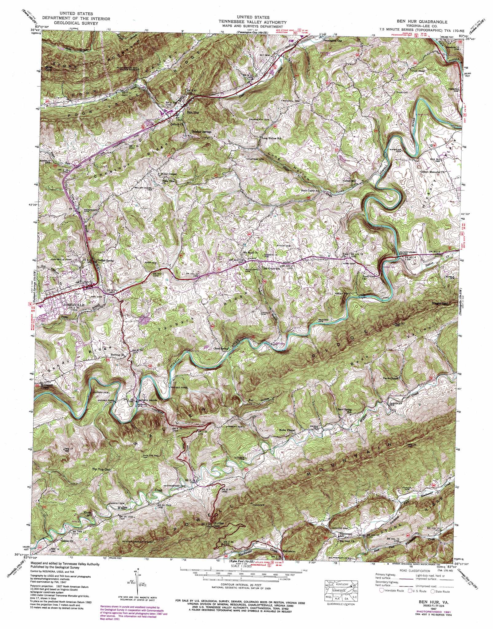
Ben Hur Topo Map Virginia
To zoom in, hover over the map of Ben Hur
USGS Topo Quad 36083f1 - 1:24,000 scale
| Topo Map Name: | Ben Hur |
| USGS Topo Quad ID: | 36083f1 |
| Print Size: | ca. 21 1/4" wide x 27" high |
| Southeast Coordinates: | 36.625° N latitude / 83° W longitude |
| Map Center Coordinates: | 36.6875° N latitude / 83.0625° W longitude |
| U.S. State: | VA |
| Filename: | o36083f1.jpg |
| Download Map JPG Image: | Ben Hur topo map 1:24,000 scale |
| Map Type: | Topographic |
| Topo Series: | 7.5´ |
| Map Scale: | 1:24,000 |
| Source of Map Images: | United States Geological Survey (USGS) |
| Alternate Map Versions: |
Ben Hur VA 1935 Download PDF Buy paper map Ben Hur VA 1947, updated 1960 Download PDF Buy paper map Ben Hur VA 1947, updated 1970 Download PDF Buy paper map Ben Hur VA 1947, updated 1970 Download PDF Buy paper map Ben Hur VA 1947, updated 1992 Download PDF Buy paper map Ben Hur VA 1949, updated 1949 Download PDF Buy paper map Ben Hur VA 1976, updated 1981 Download PDF Buy paper map Ben Hur VA 2010 Download PDF Buy paper map Ben Hur VA 2013 Download PDF Buy paper map Ben Hur VA 2016 Download PDF Buy paper map |
1:24,000 Topo Quads surrounding Ben Hur
Bledsoe |
Nolansburg |
Louellen |
Benham |
Appalachia |
Harlan |
Evarts |
Pennington Gap |
Keokee |
Big Stone Gap |
Rose Hill |
Hubbard Springs |
Ben Hur |
Stickleyville |
Duffield |
Back Valley |
Sneedville |
Kyles Ford |
Looneys Gap |
Plum Grove |
Swan Island |
Lee Valley |
Camelot |
Burem |
Stony Point |
> Back to 36083e1 at 1:100,000 scale
> Back to 36082a1 at 1:250,000 scale
> Back to U.S. Topo Maps home
Ben Hur topo map: Gazetteer
Ben Hur: Airports
Lee County Airport elevation 563m 1847′Ben Hur: Basins
Back Valley elevation 531m 1742′Ben Hur: Bridges
Poteet Ferry Bridge elevation 391m 1282′Sewell Bridge elevation 379m 1243′
Ben Hur: Crossings
Oxford Ford elevation 383m 1256′Poteet Ford elevation 385m 1263′
Ben Hur: Flats
Hickory Flats elevation 441m 1446′Ben Hur: Gaps
Bow Gap elevation 828m 2716′Hunter Gap elevation 604m 1981′
Slagle Gap elevation 648m 2125′
Tip Top Gap elevation 513m 1683′
Ben Hur: Parks
Jonesville Park elevation 497m 1630′Ben Hur: Populated Places
Ben Hur elevation 440m 1443′Blackwater elevation 371m 1217′
Collier Mill elevation 405m 1328′
Jonesville elevation 458m 1502′
Kincer Mill elevation 430m 1410′
Sulphur Springs elevation 457m 1499′
Ben Hur: Post Offices
Jonesville Post Office elevation 464m 1522′Ben Hur: Ridges
Chestnut Ridge elevation 603m 1978′Sandy Ridge elevation 480m 1574′
Tanbark Ridge elevation 491m 1610′
Wallen Ridge elevation 604m 1981′
Ben Hur: Springs
Cheek Spring elevation 396m 1299′Crockett Spring elevation 449m 1473′
Ben Hur: Streams
Laurel Branch elevation 394m 1292′Northeast Fork Blackwater Creek elevation 374m 1227′
Shafer Creek elevation 392m 1286′
Station Creek elevation 393m 1289′
Ben Hur: Valleys
Ball Hollow elevation 416m 1364′Long Hollow elevation 409m 1341′
Ben Hur digital topo map on disk
Buy this Ben Hur topo map showing relief, roads, GPS coordinates and other geographical features, as a high-resolution digital map file on DVD:
Western Virginia & Southern West Virginia
Buy digital topo maps: Western Virginia & Southern West Virginia