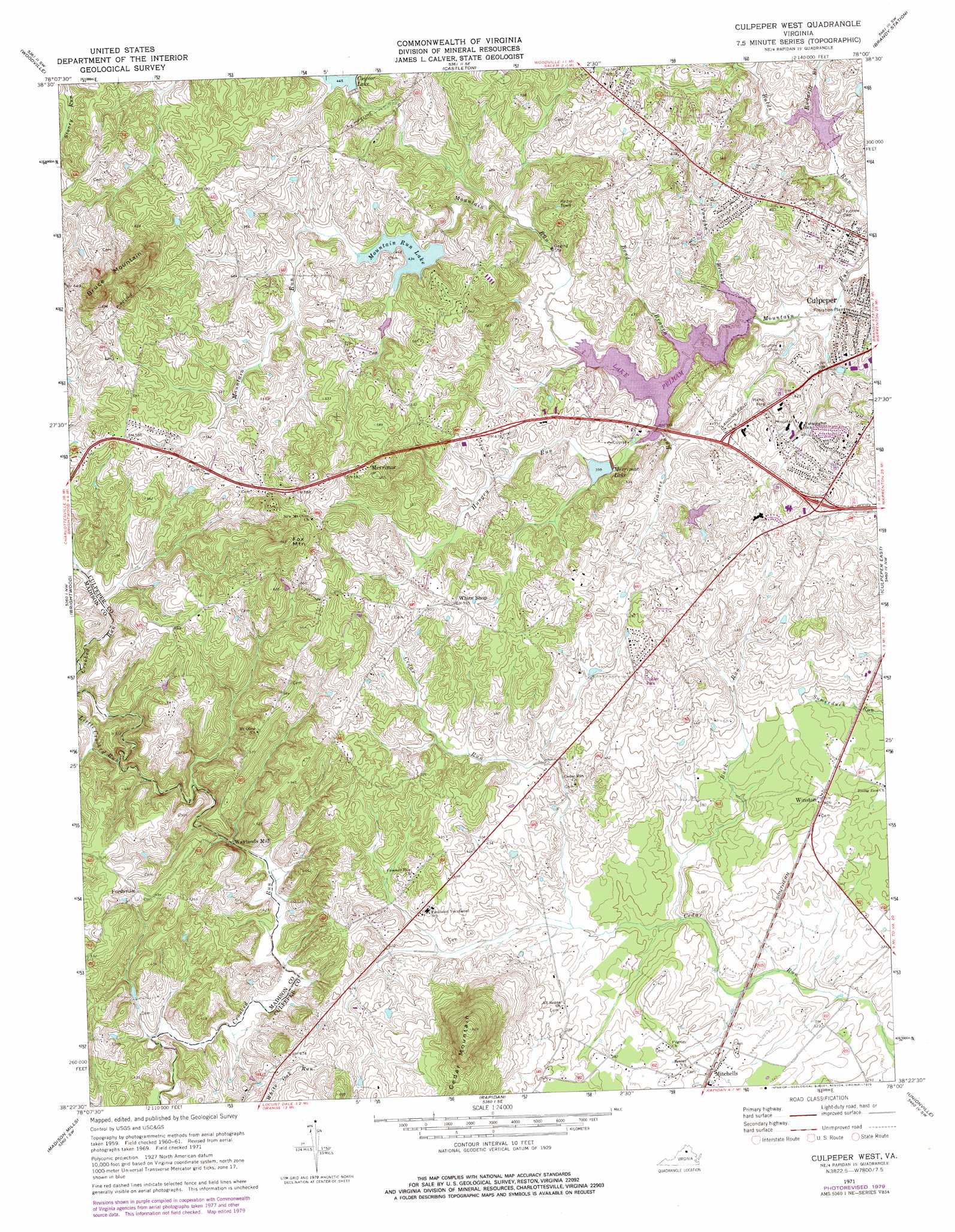
Culpeper West Topo Map Virginia
To zoom in, hover over the map of Culpeper West
USGS Topo Quad 38078d1 - 1:24,000 scale
| Topo Map Name: | Culpeper West |
| USGS Topo Quad ID: | 38078d1 |
| Print Size: | ca. 21 1/4" wide x 27" high |
| Southeast Coordinates: | 38.375° N latitude / 78° W longitude |
| Map Center Coordinates: | 38.4375° N latitude / 78.0625° W longitude |
| U.S. State: | VA |
| Filename: | o38078d1.jpg |
| Download Map JPG Image: | Culpeper West topo map 1:24,000 scale |
| Map Type: | Topographic |
| Topo Series: | 7.5´ |
| Map Scale: | 1:24,000 |
| Source of Map Images: | United States Geological Survey (USGS) |
| Alternate Map Versions: |
Culpeper West VA 1971, updated 1972 Download PDF Buy paper map Culpeper West VA 1971, updated 1979 Download PDF Buy paper map Culpeper West VA 1997, updated 1999 Download PDF Buy paper map Culpeper West VA 2010 Download PDF Buy paper map Culpeper West VA 2013 Download PDF Buy paper map Culpeper West VA 2016 Download PDF Buy paper map |
1:24,000 Topo Quads surrounding Culpeper West
Thornton Gap |
Washington |
Massies Corner |
Jeffersonton |
Warrenton |
Old Rag Mountain |
Woodville |
Castleton |
Brandy Station |
Remington |
Madison |
Brightwood |
Culpeper West |
Culpeper East |
Germanna Bridge |
Rochelle |
Madison Mills |
Rapidan |
Unionville |
Mine Run |
Barboursville |
Gordonsville |
Orange |
Lahore |
Belmont |
> Back to 38078a1 at 1:100,000 scale
> Back to 38078a1 at 1:250,000 scale
> Back to U.S. Topo Maps home
Culpeper West topo map: Gazetteer
Culpeper West: Airports
Culpeper Memorial Hospital Heliport elevation 143m 469′Culpeper West: Dams
Mountain Run Number 11 Dam elevation 132m 433′Mountain Run Number 13 Dam elevation 119m 390′
Mountain Run Number 18 Dam elevation 107m 351′
Mountain Run Number 50 Dam elevation 117m 383′
Mountain Run Number 8a Dam elevation 142m 465′
Culpeper West: Parks
Kestner Wayside Park elevation 131m 429′Culpeper West: Populated Places
Canterbury elevation 170m 557′Catalpa Hills elevation 115m 377′
Cedarbrook elevation 151m 495′
Clairmont Manor elevation 148m 485′
Clarkson elevation 180m 590′
Commonwealth Park elevation 104m 341′
Fairview Acres elevation 146m 479′
Fairview Estates elevation 140m 459′
Fordsville elevation 148m 485′
Friendship Heights elevation 145m 475′
Lakeside Mobile Home Park elevation 165m 541′
Meadowbrook Heights elevation 131m 429′
Merrimac elevation 181m 593′
Merrimac South elevation 176m 577′
Mitchells elevation 107m 351′
Mulberry Greens elevation 125m 410′
Oaklawn elevation 115m 377′
Overlook Heights elevation 145m 475′
Pelham Manor elevation 148m 485′
Rose Hill Estates elevation 160m 524′
Rotherwood elevation 158m 518′
South Ridge (historical) elevation 145m 475′
Surprise elevation 139m 456′
Village of Culpeper elevation 145m 475′
Waylands Mill elevation 122m 400′
Waylandsburg elevation 135m 442′
Westover elevation 135m 442′
Whiteshop Estates elevation 146m 479′
Whitestone Estates elevation 152m 498′
Winston elevation 118m 387′
Culpeper West: Reservoirs
Caynor Lake elevation 146m 479′Lake Pelham elevation 117m 383′
Merrimac Lake elevation 132m 433′
Merrimac Lake elevation 127m 416′
Mountain Run Lake elevation 133m 436′
Culpeper West: Streams
Bond Branch elevation 117m 383′Buck Run elevation 106m 347′
Gaines Run elevation 117m 383′
Hungry Run elevation 120m 393′
Little Crooked Run elevation 117m 383′
Rudasill Branch elevation 116m 380′
Vaughn Branch elevation 117m 383′
Culpeper West: Summits
Bruce Mountain elevation 247m 810′Fox Mountain elevation 229m 751′
Culpeper West digital topo map on disk
Buy this Culpeper West topo map showing relief, roads, GPS coordinates and other geographical features, as a high-resolution digital map file on DVD:
Western Virginia & Southern West Virginia
Buy digital topo maps: Western Virginia & Southern West Virginia