Thornton Gap Topo Map Virginia
To zoom in, hover over the map of Thornton Gap
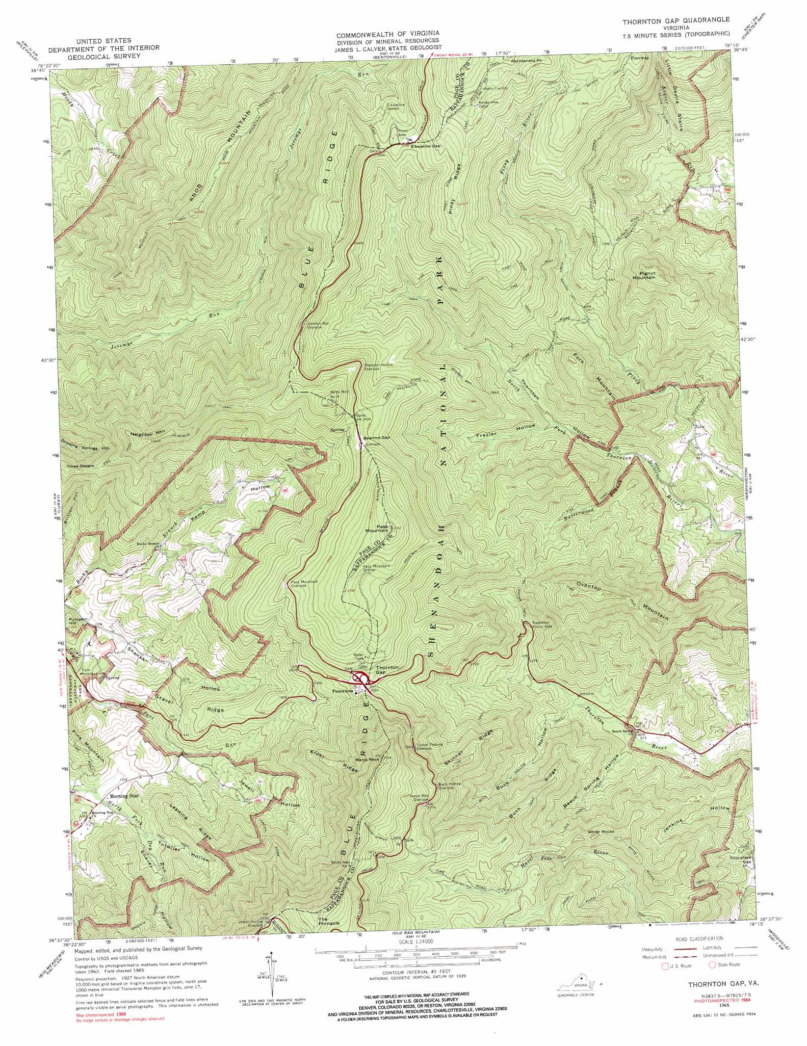
USGS Topo Quad 38078f3 - 1:24,000 scale
| Topo Map Name: | Thornton Gap |
| USGS Topo Quad ID: | 38078f3 |
| Print Size: | ca. 21 1/4" wide x 27" high |
| Southeast Coordinates: | 38.625° N latitude / 78.25° W longitude |
| Map Center Coordinates: | 38.6875° N latitude / 78.3125° W longitude |
| U.S. State: | VA |
| Filename: | o38078f3.jpg |
| Download Map JPG Image: | Thornton Gap topo map 1:24,000 scale |
| Map Type: | Topographic |
| Topo Series: | 7.5´ |
| Map Scale: | 1:24,000 |
| Source of Map Images: | United States Geological Survey (USGS) |
| Alternate Map Versions: |
Thornton Gap VA 1965, updated 1966 Download PDF Buy paper map Thornton Gap VA 1965, updated 1976 Download PDF Buy paper map Thornton Gap VA 1965, updated 1984 Download PDF Buy paper map Thornton Gap VA 1965, updated 1991 Download PDF Buy paper map Thornton Gap VA 1965, updated 1991 Download PDF Buy paper map Thornton Gap VA 1994, updated 1997 Download PDF Buy paper map Thornton Gap VA 2011 Download PDF Buy paper map Thornton Gap VA 2013 Download PDF Buy paper map Thornton Gap VA 2016 Download PDF Buy paper map |
1:24,000 Topo Quads surrounding Thornton Gap
Woodstock |
Toms Brook |
Strasburg |
Front Royal |
Linden |
Edinburg |
Rileyville |
Bentonville |
Chester Gap |
Flint Hill |
Hamburg |
Luray |
Thornton Gap |
Washington |
Massies Corner |
Stanley |
Big Meadows |
Old Rag Mountain |
Woodville |
Castleton |
Elkton East |
Fletcher |
Madison |
Brightwood |
Culpeper West |
> Back to 38078e1 at 1:100,000 scale
> Back to 38078a1 at 1:250,000 scale
> Back to U.S. Topo Maps home
Thornton Gap topo map: Gazetteer
Thornton Gap: Dams
Dry Run Number 102 Dam elevation 413m 1354′Thornton Gap: Gaps
Beahms Gap elevation 750m 2460′Elkwallow Gap elevation 745m 2444′
Thornton Gap elevation 697m 2286′
Thorofare Gap elevation 305m 1000′
Thornton Gap: Pillars
The Pinnacle elevation 1127m 3697′White Rocks elevation 600m 1968′
Thornton Gap: Populated Places
Fourway elevation 820m 2690′Morning Star elevation 410m 1345′
Thornton Gap: Reservoirs
Morning Star Lake elevation 413m 1354′Thornton Gap: Ridges
Buck Ridge elevation 617m 2024′Elder Ridge elevation 797m 2614′
Gravel Ridge elevation 473m 1551′
Leading Ridge elevation 573m 1879′
Piney Ridge elevation 809m 2654′
Skinner Ridge elevation 720m 2362′
Thornton Gap: Streams
Butterwood Branch elevation 320m 1049′Thornton Gap: Summits
Fork Mountain elevation 622m 2040′Knob Mountain elevation 814m 2670′
Marys Rock elevation 1063m 3487′
Neighbor Mountain elevation 796m 2611′
Oventop Mountain elevation 752m 2467′
Pass Mountain elevation 915m 3001′
Pignut Mountain elevation 771m 2529′
Pumpkin Hill elevation 409m 1341′
Thornton Gap: Trails
Beahms Gap Trail elevation 507m 1663′Crusher Ridge Trail elevation 725m 2378′
Hazel River Trail elevation 519m 1702′
Hollow Trail elevation 432m 1417′
Jeremys Run Trail elevation 446m 1463′
Knob Mountain Trail elevation 750m 2460′
Leading Ridge Trail elevation 734m 2408′
Little Devils Stairs Trail elevation 496m 1627′
Meadow Spring Trail elevation 933m 3061′
Neighbor Trail elevation 753m 2470′
Pass Mountain Trail elevation 766m 2513′
Piney Branch Trail elevation 520m 1706′
Piney Ridge Trail elevation 761m 2496′
Pole Link Bridge Trail elevation 816m 2677′
Turn Bridge Trail elevation 481m 1578′
White Rocks Trail elevation 610m 2001′
Thornton Gap: Valleys
Beech Spring Hollow elevation 290m 951′Buck Hollow elevation 316m 1036′
Frazier Hollow elevation 363m 1190′
Jewell Hollow elevation 394m 1292′
Kemp Hollow elevation 395m 1295′
Little Devils Stairs elevation 427m 1400′
Shaver Hollow elevation 415m 1361′
Shenks Hollow elevation 313m 1026′
Thornton Hollow elevation 337m 1105′
Tutwiler Hollow elevation 449m 1473′
Thornton Gap digital topo map on disk
Buy this Thornton Gap topo map showing relief, roads, GPS coordinates and other geographical features, as a high-resolution digital map file on DVD:
Western Virginia & Southern West Virginia
Buy digital topo maps: Western Virginia & Southern West Virginia