Wheelersburg Topo Map Ohio
To zoom in, hover over the map of Wheelersburg
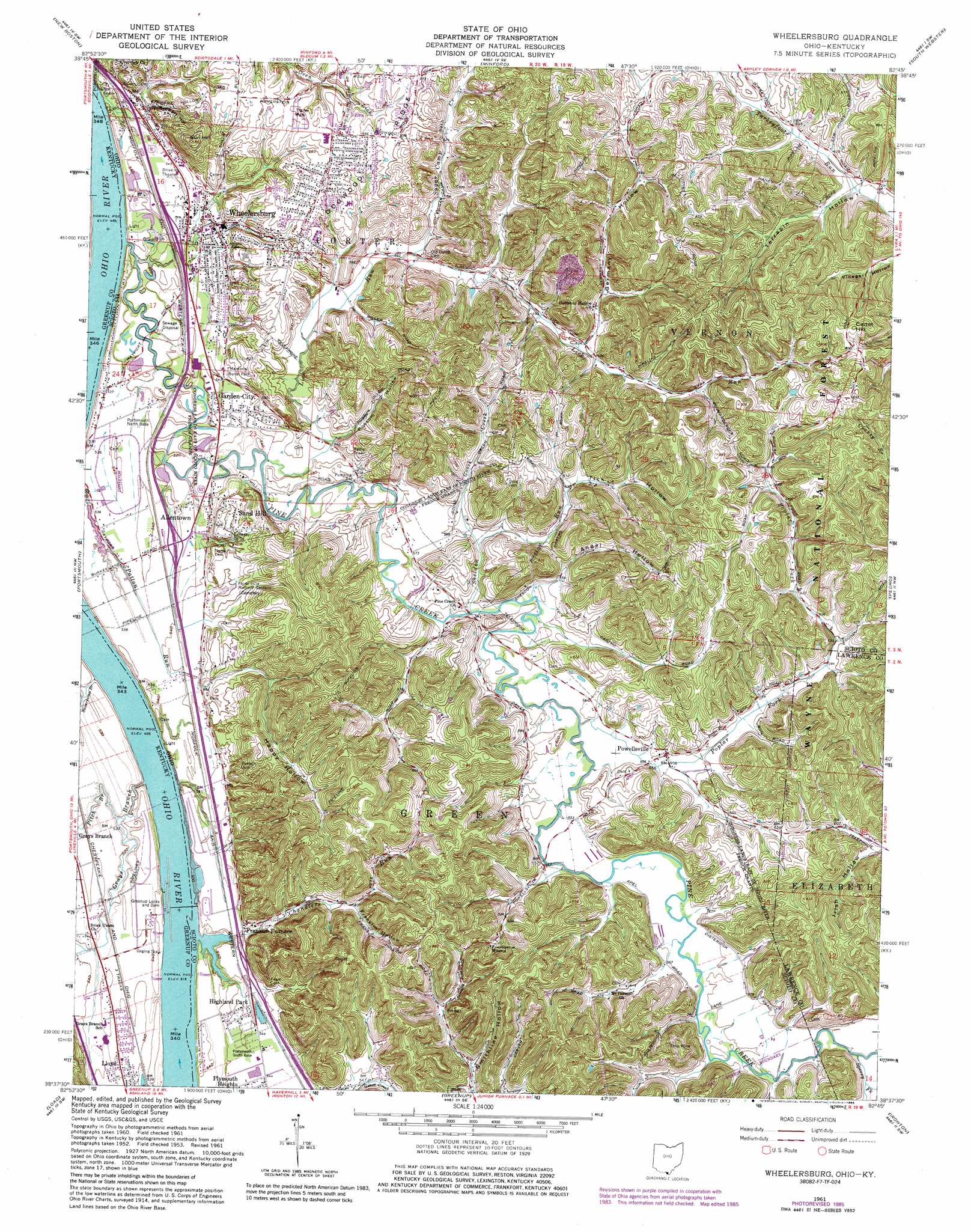
USGS Topo Quad 38082f7 - 1:24,000 scale
| Topo Map Name: | Wheelersburg |
| USGS Topo Quad ID: | 38082f7 |
| Print Size: | ca. 21 1/4" wide x 27" high |
| Southeast Coordinates: | 38.625° N latitude / 82.75° W longitude |
| Map Center Coordinates: | 38.6875° N latitude / 82.8125° W longitude |
| U.S. States: | OH, KY |
| Filename: | o38082f7.jpg |
| Download Map JPG Image: | Wheelersburg topo map 1:24,000 scale |
| Map Type: | Topographic |
| Topo Series: | 7.5´ |
| Map Scale: | 1:24,000 |
| Source of Map Images: | United States Geological Survey (USGS) |
| Alternate Map Versions: |
Wheelersburg OH 1961, updated 1963 Download PDF Buy paper map Wheelersburg OH 1961, updated 1972 Download PDF Buy paper map Wheelersburg OH 1961, updated 1977 Download PDF Buy paper map Wheelersburg OH 1961, updated 1985 Download PDF Buy paper map Wheelersburg OH 2002, updated 2006 Download PDF Buy paper map Wheelersburg OH 2011 Download PDF Buy paper map Wheelersburg OH 2013 Download PDF Buy paper map Wheelersburg OH 2016 Download PDF Buy paper map |
| FStopo: | US Forest Service topo Wheelersburg is available: Download FStopo PDF Download FStopo TIF |
1:24,000 Topo Quads surrounding Wheelersburg
Wakefield |
Lucasville |
Stockdale |
Petersburg |
Oak Hill |
West Portsmouth |
New Boston |
Minford |
South Webster |
Gallia |
Friendship |
Portsmouth |
Wheelersburg |
Pedro |
Sherritts |
Brushart |
Load |
Greenup |
Ironton |
Kitts Hill |
Tygarts Valley |
Oldtown |
Argillite |
Ashland |
Catlettsburg |
> Back to 38082e1 at 1:100,000 scale
> Back to 38082a1 at 1:250,000 scale
> Back to U.S. Topo Maps home
Wheelersburg topo map: Gazetteer
Wheelersburg: Dams
Greenup Locks and Dam elevation 155m 508′Wheelersburg: Populated Places
Allentown elevation 162m 531′Crestview Park elevation 205m 672′
Franklin Furnace elevation 175m 574′
Garden City elevation 165m 541′
Highland Park elevation 165m 541′
Powellsville elevation 171m 561′
Sand Hill elevation 164m 538′
Wheelersburg elevation 169m 554′
Wheelersburg: Post Offices
Franklin Furnace Post Office elevation 177m 580′Powellsville Post Office (historical) elevation 171m 561′
Wheelersburg Post Office elevation 169m 554′
Wheelersburg: Ridges
Dogwood Ridge elevation 205m 672′Tick Ridge elevation 263m 862′
Wheelersburg: Streams
Chandlers Run elevation 158m 518′Goose Creek elevation 168m 551′
Grays Branch elevation 150m 492′
Lick Run elevation 159m 521′
Lick Run Lick Run elevation 160m 524′
North Fork Lick Run elevation 181m 593′
Pine Creek elevation 152m 498′
Pitch Branch elevation 158m 518′
Poplar Fork Pine Creek elevation 165m 541′
Sheldon Run elevation 164m 538′
Slash Branch elevation 162m 531′
Sperry Fork elevation 171m 561′
Sugar Camp Creek elevation 173m 567′
Sugarcamp Branch elevation 149m 488′
Wheelersburg: Summits
Cadot Hill elevation 274m 898′Sun Hill elevation 257m 843′
Wheelersburg: Valleys
Angel Hollow elevation 173m 567′Coyle Hollow elevation 172m 564′
Franklin Hollow elevation 186m 610′
Germany Hollow elevation 183m 600′
Happy Hollow elevation 168m 551′
Irish Hollow elevation 177m 580′
Possum Hollow elevation 170m 557′
Railpike Hollow elevation 167m 547′
Riepenhoff Hollow elevation 176m 577′
Sager Hollow elevation 166m 544′
Smithline Hollow elevation 181m 593′
Stewart Hollow elevation 170m 557′
Terrapin Hollow elevation 189m 620′
Tick Hollow elevation 188m 616′
Wheelersburg digital topo map on disk
Buy this Wheelersburg topo map showing relief, roads, GPS coordinates and other geographical features, as a high-resolution digital map file on DVD:
Western Virginia & Southern West Virginia
Buy digital topo maps: Western Virginia & Southern West Virginia