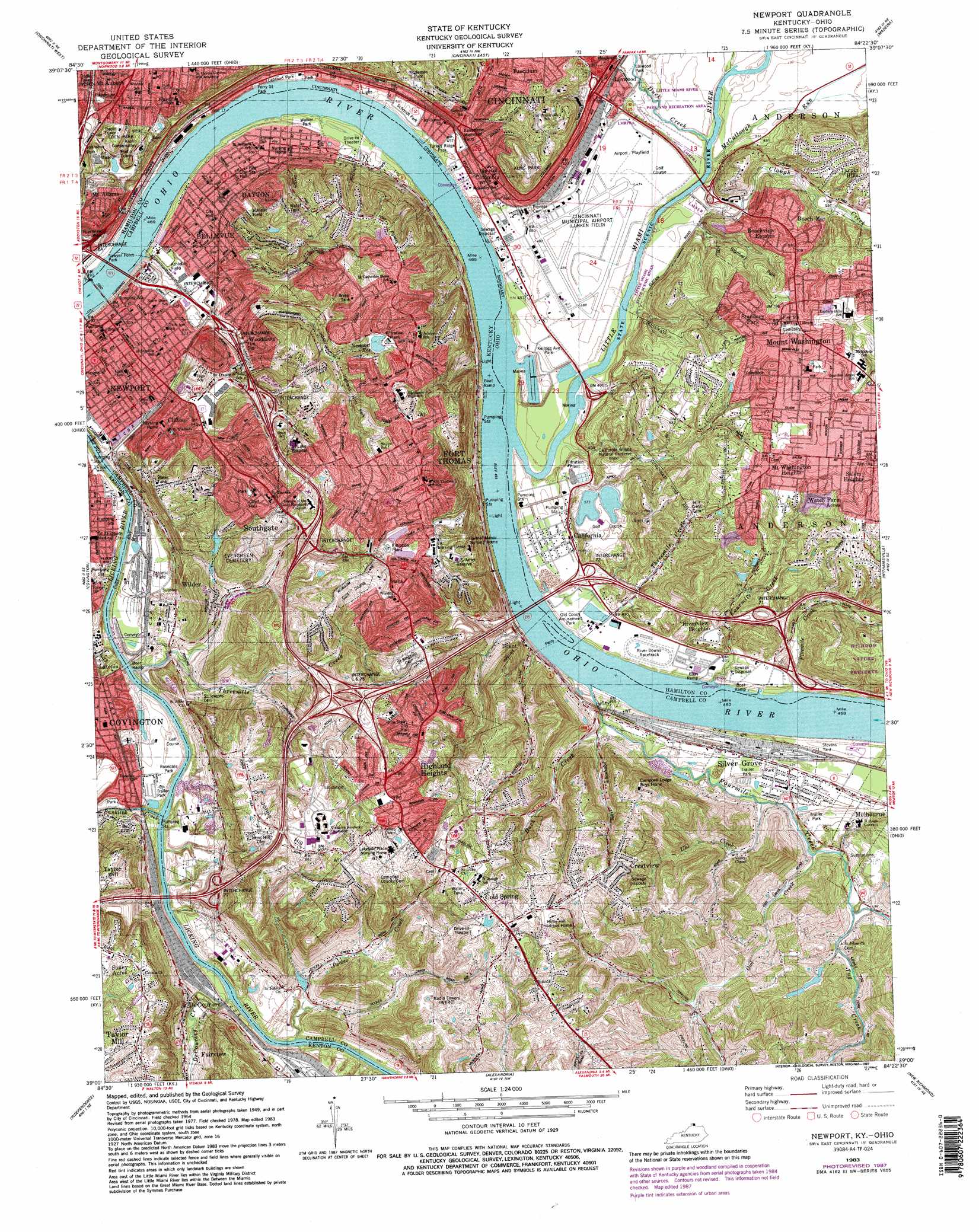
Newport Topo Map Kentucky
To zoom in, hover over the map of Newport
USGS Topo Quad 39084a4 - 1:24,000 scale
| Topo Map Name: | Newport |
| USGS Topo Quad ID: | 39084a4 |
| Print Size: | ca. 21 1/4" wide x 27" high |
| Southeast Coordinates: | 39° N latitude / 84.375° W longitude |
| Map Center Coordinates: | 39.0625° N latitude / 84.4375° W longitude |
| U.S. States: | KY, OH |
| Filename: | o39084a4.jpg |
| Download Map JPG Image: | Newport topo map 1:24,000 scale |
| Map Type: | Topographic |
| Topo Series: | 7.5´ |
| Map Scale: | 1:24,000 |
| Source of Map Images: | United States Geological Survey (USGS) |
| Alternate Map Versions: |
Newport KY 1952, updated 1953 Download PDF Buy paper map Newport KY 1955, updated 1957 Download PDF Buy paper map Newport KY 1961, updated 1963 Download PDF Buy paper map Newport KY 1961, updated 1971 Download PDF Buy paper map Newport KY 1961, updated 1975 Download PDF Buy paper map Newport KY 1983, updated 1984 Download PDF Buy paper map Newport KY 1983, updated 1987 Download PDF Buy paper map Newport KY 2010 Download PDF Buy paper map Newport KY 2013 Download PDF Buy paper map Newport KY 2016 Download PDF Buy paper map |
1:24,000 Topo Quads surrounding Newport
Shandon |
Greenhills |
Glendale |
Mason |
South Lebanon |
Addyston |
Cincinnati West |
Cincinnati East |
Madeira |
Goshen |
Burlington |
Covington |
Newport |
Withamsville |
Batavia |
Union |
Independence |
Alexandria |
New Richmond |
Laurel |
Verona |
Walton |
De Mossville |
Butler |
Moscow |
> Back to 39084a1 at 1:100,000 scale
> Back to 39084a1 at 1:250,000 scale
> Back to U.S. Topo Maps home
Newport topo map: Gazetteer
Newport: Airports
Cincinnati Municipal Airport elevation 144m 472′Horizon Heliport elevation 152m 498′
Horizons Heliport elevation 148m 485′
Midwest Communication Heliport elevation 237m 777′
Saint Luke Hospital Heliport elevation 240m 787′
Newport: Bars
Five Mile Bar elevation 137m 449′Newport: Bridges
Combs-Hehl Bridge elevation 136m 446′Daniel Beard Bridge elevation 136m 446′
Ida Street Bridge elevation 220m 721′
L & N Pedestrian Bridge elevation 139m 456′
Melan Arch Bridge elevation 239m 784′
Newport Southbank Bridge elevation 140m 459′
Shortway Bridge (historical) elevation 138m 452′
Newport: Crossings
Brent Ferry (historical) elevation 133m 436′Dayton Ferry (historical) elevation 135m 442′
Interchange 1 elevation 237m 777′
Interchange 2 elevation 213m 698′
Interchange 4 elevation 200m 656′
Interchange 5 elevation 159m 521′
Interchange 6 elevation 153m 501′
Interchange 6A elevation 152m 498′
Interchange 71 elevation 180m 590′
Interchange 72 elevation 152m 498′
Interchange 75 elevation 237m 777′
Interchange 77 elevation 184m 603′
Newport Ferry (historical) elevation 136m 446′
Newport: Dams
Apple Hill Farm Lake Dam elevation 176m 577′Fourmile Lake Dam elevation 202m 662′
Lake Louise Dam elevation 181m 593′
Newport: Flats
Turkey Bottom elevation 144m 472′Newport: Harbors
Bridgeview Harbor elevation 139m 456′Wewes Boat Harbor elevation 140m 459′
Newport: Parks
Airport Playfield elevation 145m 475′Alms Park elevation 248m 813′
Alums Park elevation 232m 761′
Anderson Park elevation 192m 629′
California Woods Natural Preserve elevation 162m 531′
Chatfield Memorial elevation 190m 623′
East End Park (historical) elevation 146m 479′
Eden Park elevation 226m 741′
Ferry Street Park elevation 148m 485′
Frank Ignatius Grein Softball Field elevation 259m 849′
Friendship Field elevation 263m 862′
Gilbert-Sinton Historic District elevation 238m 780′
Highland Hills Park elevation 237m 777′
Johnston Park elevation 216m 708′
Kellogg Avenue Park elevation 148m 485′
Leblond Park elevation 149m 488′
Linwood Park elevation 147m 482′
Little Miami River Park and Recreation Area elevation 146m 479′
LIttle Miami State Scenic River elevation 144m 472′
Mount Adams Playground elevation 239m 784′
Old Coney Amusement Park elevation 147m 482′
Rakestraw Memorial Field elevation 151m 495′
Riverview Park elevation 172m 564′
Rosedale Park elevation 150m 492′
Royal Oaks Park elevation 235m 770′
Sawyer Point Park elevation 149m 488′
Stanberry Park elevation 216m 708′
Tacoma Park (historical) elevation 149m 488′
Theodore M Berry International Friendship Park elevation 142m 465′
Turkey Ridge Park elevation 147m 482′
Walker Park elevation 143m 469′
Withrow Nature Preserve elevation 161m 528′
Newport: Populated Places
Beech-Mar elevation 197m 646′Beechview Estates elevation 213m 698′
Bellevue elevation 167m 547′
Brent elevation 150m 492′
California elevation 155m 508′
Clifton elevation 194m 636′
Cold Spring elevation 264m 866′
Columbia elevation 160m 524′
Cote Brilliant elevation 155m 508′
Crestview elevation 245m 803′
Dayton elevation 157m 515′
DeCoursey elevation 168m 551′
Fort Thomas elevation 262m 859′
Fulton elevation 156m 511′
Highland Heights elevation 260m 853′
Johns Hill elevation 165m 541′
Mount Adams elevation 222m 728′
Mount Washington elevation 227m 744′
Newport elevation 156m 511′
Pendleton elevation 152m 498′
Pools Creek elevation 173m 567′
Reeses Settlement (historical) elevation 261m 856′
Riverview Heights elevation 179m 587′
Salem Heights elevation 227m 744′
Silver Grove elevation 151m 495′
Southgate elevation 210m 688′
Stanbery Park elevation 243m 797′
Sunny Acres elevation 260m 853′
Sweetwine (historical) elevation 153m 501′
The Estates At Wiedemann Mansion elevation 184m 603′
Tug Fork (historical) elevation 167m 547′
Turpin Hills elevation 198m 649′
Tusculum elevation 209m 685′
Watch Farm Acres elevation 250m 820′
Wilder elevation 165m 541′
Winston Hills (historical) elevation 153m 501′
Woodlawn elevation 167m 547′
Newport: Post Offices
Brent Post Office (historical) elevation 155m 508′California Post Office (historical) elevation 154m 505′
Columbia Post Office (historical) elevation 158m 518′
Dale Post Office (historical) elevation 254m 833′
Fulton Post Office (historical) elevation 162m 531′
Highland Heights Post Office elevation 256m 839′
Johns Hill Post Office (historical) elevation 154m 505′
Licking Post Office (historical) elevation 176m 577′
Mount Washington Post Office (historical) elevation 243m 797′
Silver Grove Post Office (historical) elevation 151m 495′
Sweetwine Post Office (historical) elevation 155m 508′
Newport: Reservoirs
Apple Hill Farm Lake elevation 176m 577′Covington Reservoirs elevation 245m 803′
Fourmile Lake elevation 202m 662′
Lake Inferior elevation 253m 830′
Lake Louise elevation 181m 593′
Mirror Lake elevation 204m 669′
Newport Reservoir elevation 221m 725′
Wolking Lake (historical) elevation 155m 508′
Newport: Streams
Banklick Creek elevation 141m 462′Clough Creek elevation 145m 475′
DeCoursey Creek elevation 140m 459′
Duck Creek elevation 140m 459′
Duck Creek elevation 139m 456′
Fivemile Creek elevation 139m 456′
Fourmile Creek elevation 145m 475′
Fourmile Creek elevation 140m 459′
Little Miami River elevation 136m 446′
McCullough Run elevation 140m 459′
Owl Creek elevation 148m 485′
Pooles Creek elevation 139m 456′
Threemile Creek elevation 147m 482′
Threemile Creek elevation 138m 452′
Tug Creek elevation 149m 488′
Uhl Creek elevation 144m 472′
Newport: Summits
Johns Hill elevation 256m 839′Mount Adams elevation 247m 810′
Newport: Woods
Authors Grove elevation 249m 816′Heros Grove elevation 219m 718′
Newport digital topo map on disk
Buy this Newport topo map showing relief, roads, GPS coordinates and other geographical features, as a high-resolution digital map file on DVD:
Northern Illinois, Northern Indiana & Southwestern Michigan
Buy digital topo maps: Northern Illinois, Northern Indiana & Southwestern Michigan