Copper Mountain Topo Map Colorado
To zoom in, hover over the map of Copper Mountain
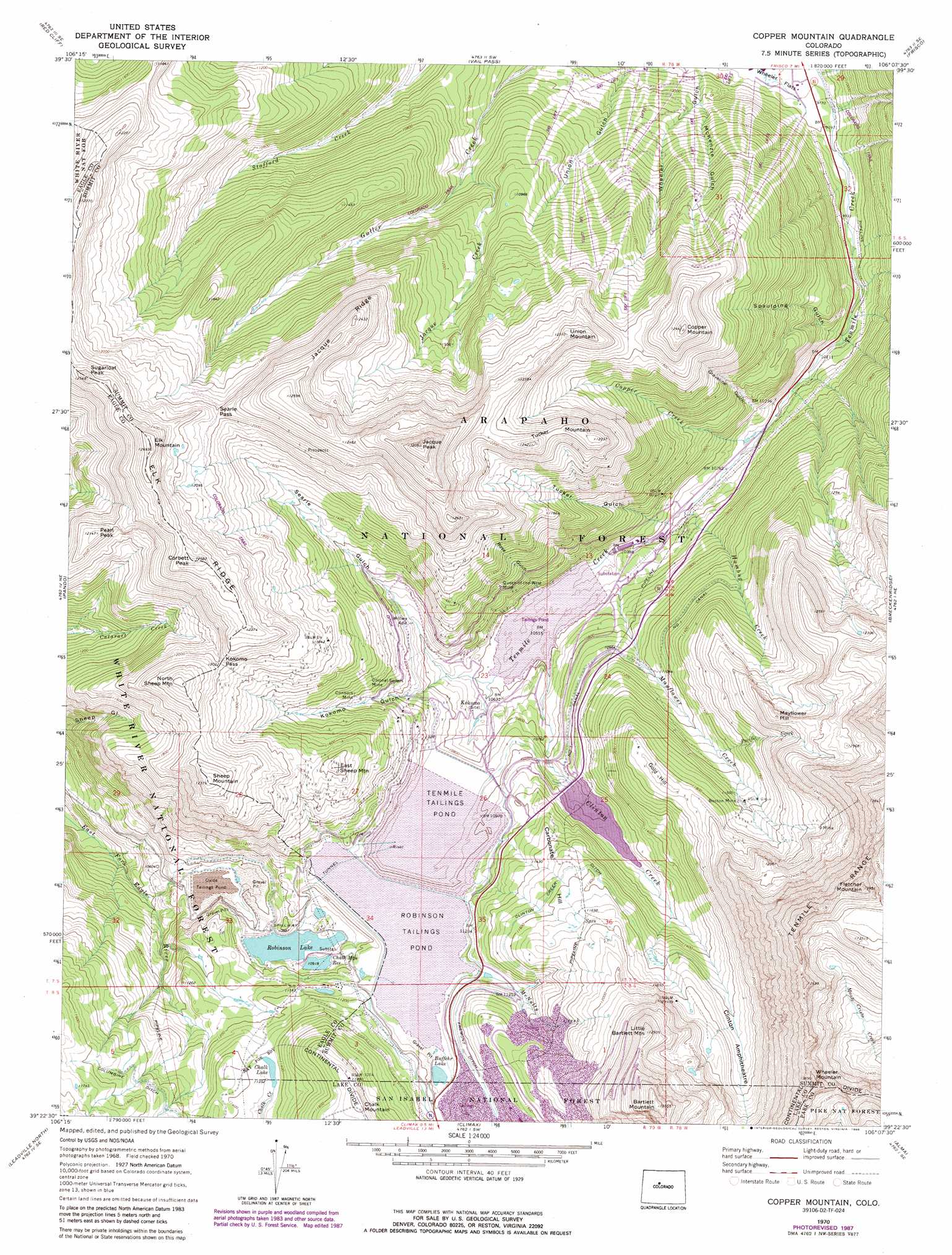
USGS Topo Quad 39106d2 - 1:24,000 scale
| Topo Map Name: | Copper Mountain |
| USGS Topo Quad ID: | 39106d2 |
| Print Size: | ca. 21 1/4" wide x 27" high |
| Southeast Coordinates: | 39.375° N latitude / 106.125° W longitude |
| Map Center Coordinates: | 39.4375° N latitude / 106.1875° W longitude |
| U.S. State: | CO |
| Filename: | o39106d2.jpg |
| Download Map JPG Image: | Copper Mountain topo map 1:24,000 scale |
| Map Type: | Topographic |
| Topo Series: | 7.5´ |
| Map Scale: | 1:24,000 |
| Source of Map Images: | United States Geological Survey (USGS) |
| Alternate Map Versions: |
Copper Mountain CO 1970, updated 1973 Download PDF Buy paper map Copper Mountain CO 1970, updated 1973 Download PDF Buy paper map Copper Mountain CO 1970, updated 1988 Download PDF Buy paper map Copper Mountain CO 1970, updated 1988 Download PDF Buy paper map Copper Mountain CO 2011 Download PDF Buy paper map Copper Mountain CO 2013 Download PDF Buy paper map Copper Mountain CO 2016 Download PDF Buy paper map |
| FStopo: | US Forest Service topo Copper Mountain is available: Download FStopo PDF Download FStopo TIF |
1:24,000 Topo Quads surrounding Copper Mountain
Vail West |
Vail East |
Willow Lakes |
Dillon |
Loveland Pass |
Minturn |
Red Cliff |
Vail Pass |
Frisco |
Keystone |
Mount Of The Holy Cross |
Pando |
Copper Mountain |
Breckenridge |
Boreas Pass |
Homestake Reservoir |
Leadville North |
Climax |
Alma |
Como |
Mount Massive |
Leadville South |
Mount Sherman |
Fairplay West |
Fairplay East |
> Back to 39106a1 at 1:100,000 scale
> Back to 39106a1 at 1:250,000 scale
> Back to U.S. Topo Maps home
Copper Mountain topo map: Gazetteer
Copper Mountain: Basins
Clinton Amphitheatre elevation 3565m 11696′Copper Mountain: Canals
Clinton Creek Ditch elevation 3527m 11571′Columbine Ditch elevation 3499m 11479′
Fremont Ditch elevation 3445m 11302′
Copper Mountain: Dams
Buffehrs Dam elevation 3671m 12043′Chalk Mountain Dam elevation 3330m 10925′
Climax-Moly Number 4 Dam elevation 3245m 10646′
Clinton Gulch Dam elevation 3376m 11076′
Robinson Dam elevation 3333m 10935′
Copper Mountain: Gaps
Kokomo Pass elevation 3666m 12027′Searle Pass elevation 3668m 12034′
Copper Mountain: Lakes
Buffehr Lake elevation 3400m 11154′Robinson Tailings Pond elevation 3392m 11128′
Copper Mountain: Mines
American Metals Incline Mine elevation 3806m 12486′American Placer Mine elevation 3585m 11761′
Armstrong Mine elevation 3377m 11079′
Axtell Tunnel Mine elevation 3429m 11250′
Boston Mine elevation 3634m 11922′
Brain Mine elevation 3229m 10593′
Champion Mine elevation 3231m 10600′
Cole Peterson Mine elevation 3234m 10610′
Colonel Sellers Mine elevation 3451m 11322′
Columbia Group Mine elevation 3932m 12900′
Connors Mine elevation 3432m 11259′
D and G Mine elevation 3231m 10600′
Delaware Mine elevation 3377m 11079′
Delphos Mine elevation 3377m 11079′
El Dorado Shaft Mine elevation 3350m 10990′
Fugitive Mine elevation 3534m 11594′
Iron Mask Mine elevation 3227m 10587′
Kimberly Mine elevation 3377m 11079′
Little Artist Group Mine elevation 3377m 11079′
Lucky Strike Mine elevation 3806m 12486′
Michigan Mine elevation 3227m 10587′
Nettie B Mine elevation 3227m 10587′
New Shaft Mine elevation 3432m 11259′
Queen-of-the-West Mine elevation 3375m 11072′
Queen-of-the-West Mine elevation 3365m 11040′
Raven Eagle Tunnel Mine elevation 3493m 11459′
Selma Mine elevation 3720m 12204′
Silver Queen Mine elevation 3220m 10564′
Snowbank Mine elevation 3227m 10587′
Ten Mile Tunnel Mine elevation 3448m 11312′
Uthoff Mine elevation 3227m 10587′
Victory Tunnel Mine elevation 3806m 12486′
Walsh Incline Mine elevation 3806m 12486′
Washington Mine elevation 3329m 10921′
Weller Mine elevation 3578m 11738′
Wheel of Fortune Mine elevation 3569m 11709′
Wifley Mine elevation 3318m 10885′
Wilfley Adit elevation 3326m 10912′
Wilson Mine elevation 3623m 11886′
Wintergreen Mine elevation 3307m 10849′
Copper Mountain: Populated Places
Kokomo (historical) elevation 3260m 10695′Copper Mountain: Reservoirs
Buffehrs Reservoir elevation 3671m 12043′Chalk Lake elevation 3460m 11351′
Chalk Mountain Reservoir elevation 3330m 10925′
Climax-Moly Number 4 Reservoir elevation 3245m 10646′
Clinton Gulch Dam Reservoir elevation 3376m 11076′
Mayflower Trailings Pond elevation 3184m 10446′
Oxide Tailings Pond elevation 3274m 10741′
Robinson Lake elevation 3320m 10892′
Robinson Reservoir elevation 3333m 10935′
Tenmile Tailings Pond elevation 3319m 10889′
Copper Mountain: Ridges
Elk Ridge elevation 3797m 12457′Jacque Ridge elevation 3756m 12322′
Copper Mountain: Streams
Clinton Creek elevation 3208m 10524′Copper Creek elevation 3120m 10236′
Humbug Creek elevation 3146m 10321′
Jacque Creek elevation 3184m 10446′
Mayflower Creek elevation 3344m 10971′
McNulty Creek elevation 3404m 11167′
Pacific Creek elevation 3450m 11318′
Copper Mountain: Summits
Atlantic Peak elevation 4211m 13815′Bartlett Mountain elevation 4128m 13543′
Carbonate Hill elevation 3501m 11486′
Copper Mountain elevation 3788m 12427′
Corbett Peak elevation 3700m 12139′
East Sheep Mountain elevation 3626m 11896′
Elk Mountain elevation 3858m 12657′
Fletcher Mountain elevation 4239m 13907′
Gold Hill elevation 3638m 11935′
Jacque Peak elevation 4001m 13126′
Little Bartlett Mountain elevation 3943m 12936′
Mayflower Hill elevation 3763m 12345′
North Sheep Mountain elevation 3785m 12417′
Pearl Peak elevation 3698m 12132′
Sheep Mountain elevation 3770m 12368′
Sugarloaf Peak elevation 3823m 12542′
Tucker Mountain elevation 3721m 12208′
Union Mountain elevation 3749m 12299′
Wheeler Mountain elevation 4154m 13628′
Copper Mountain: Trails
Wheeler Trail elevation 3070m 10072′Copper Mountain: Valleys
Graveline Gulch elevation 3202m 10505′Kokomo Gulch elevation 3294m 10807′
McKenzie Gulch elevation 3059m 10036′
Rose Gulch elevation 3305m 10843′
Searle Gulch elevation 3256m 10682′
Spaulding Gulch elevation 3125m 10252′
Tucker Gulch elevation 3242m 10636′
Union Gulch elevation 3011m 9878′
Wheeler Gulch elevation 2974m 9757′
Copper Mountain digital topo map on disk
Buy this Copper Mountain topo map showing relief, roads, GPS coordinates and other geographical features, as a high-resolution digital map file on DVD: