Mount Of The Holy Cross Topo Map Colorado
To zoom in, hover over the map of Mount Of The Holy Cross
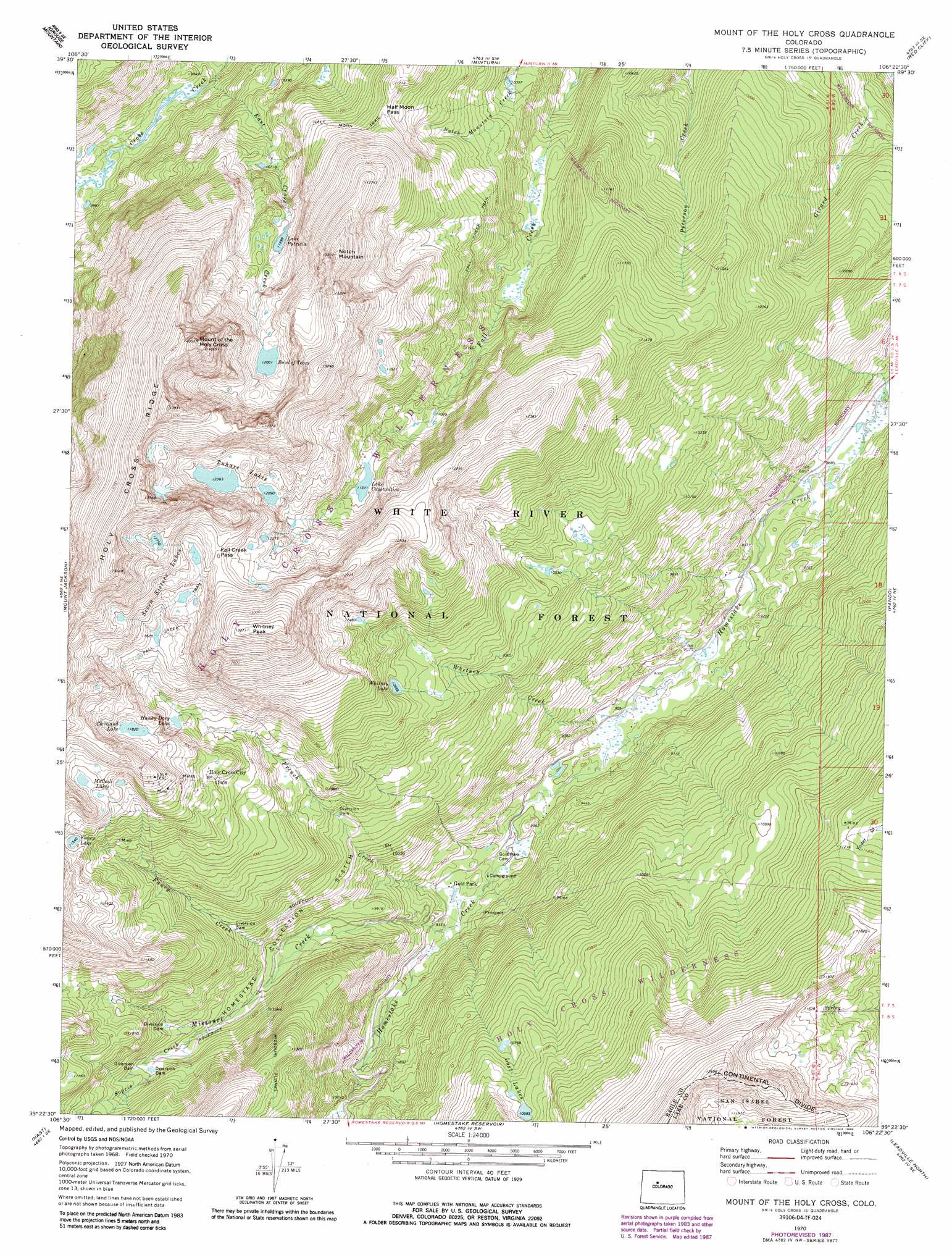
USGS Topo Quad 39106d4 - 1:24,000 scale
| Topo Map Name: | Mount Of The Holy Cross |
| USGS Topo Quad ID: | 39106d4 |
| Print Size: | ca. 21 1/4" wide x 27" high |
| Southeast Coordinates: | 39.375° N latitude / 106.375° W longitude |
| Map Center Coordinates: | 39.4375° N latitude / 106.4375° W longitude |
| U.S. State: | CO |
| Filename: | o39106d4.jpg |
| Download Map JPG Image: | Mount Of The Holy Cross topo map 1:24,000 scale |
| Map Type: | Topographic |
| Topo Series: | 7.5´ |
| Map Scale: | 1:24,000 |
| Source of Map Images: | United States Geological Survey (USGS) |
| Alternate Map Versions: |
Mount Of The Holy Cross CO 1970, updated 1973 Download PDF Buy paper map Mount Of The Holy Cross CO 1970, updated 1973 Download PDF Buy paper map Mount Of The Holy Cross CO 1970, updated 1980 Download PDF Buy paper map Mount Of The Holy Cross CO 1970, updated 1988 Download PDF Buy paper map Mount Of The Holy Cross CO 1970, updated 1988 Download PDF Buy paper map Mount of the Holy Cross CO 2011 Download PDF Buy paper map Mount of the Holy Cross CO 2013 Download PDF Buy paper map Mount of the Holy Cross CO 2016 Download PDF Buy paper map |
| FStopo: | US Forest Service topo Mount of the Holy Cross is available: Download FStopo PDF Download FStopo TIF |
1:24,000 Topo Quads surrounding Mount Of The Holy Cross
Wolcott |
Edwards |
Vail West |
Vail East |
Willow Lakes |
Fulford |
Grouse Mountain |
Minturn |
Red Cliff |
Vail Pass |
Crooked Creek Pass |
Mount Jackson |
Mount Of The Holy Cross |
Pando |
Copper Mountain |
Meredith |
Nast |
Homestake Reservoir |
Leadville North |
Climax |
Thimble Rock |
Mount Champion |
Mount Massive |
Leadville South |
Mount Sherman |
> Back to 39106a1 at 1:100,000 scale
> Back to 39106a1 at 1:250,000 scale
> Back to U.S. Topo Maps home
Mount Of The Holy Cross topo map: Gazetteer
Mount Of The Holy Cross: Gaps
Fall Creek Pass elevation 3916m 12847′Half Moon Pass elevation 3547m 11637′
Mount Of The Holy Cross: Lakes
Bowl of Tears elevation 3660m 12007′Cleveland Lake elevation 3605m 11827′
Fancy Lake elevation 3522m 11555′
Hunky Dory Lake elevation 3449m 11315′
Lake Constantine elevation 3468m 11377′
Lost Lakes elevation 3331m 10928′
Mulhall Lakes elevation 3621m 11879′
Seven Sisters Lakes elevation 3721m 12208′
Tuhare Lakes elevation 3771m 12372′
Whitney Lake elevation 3340m 10958′
Mount Of The Holy Cross: Mines
Glengarry Mine elevation 3479m 11414′Morning Mine elevation 2832m 9291′
Newman Mine elevation 3434m 11266′
Mount Of The Holy Cross: Populated Places
Holy Cross City (historical) elevation 3483m 11427′Mount Of The Holy Cross: Ridges
Holy Cross Ridge elevation 4204m 13792′Mount Of The Holy Cross: Streams
East Cross Creek elevation 2973m 9753′Fancy Creek elevation 3002m 9849′
French Creek elevation 2825m 9268′
Missouri Creek elevation 2838m 9311′
Sopris Creek elevation 3098m 10164′
Whitney Creek elevation 2796m 9173′
Mount Of The Holy Cross: Summits
Mount of the Holy Cross elevation 4268m 14002′Notch Mountain elevation 4030m 13221′
Whitney Peak elevation 4041m 13257′
Mount Of The Holy Cross: Trails
Fall Creek Trail elevation 3377m 11079′Half Moon Trail elevation 3426m 11240′
Mount Of The Holy Cross: Tunnels
Missouri Tunnel elevation 3437m 11276′Mount Of The Holy Cross digital topo map on disk
Buy this Mount Of The Holy Cross topo map showing relief, roads, GPS coordinates and other geographical features, as a high-resolution digital map file on DVD: