Dog Valley Topo Map California
To zoom in, hover over the map of Dog Valley
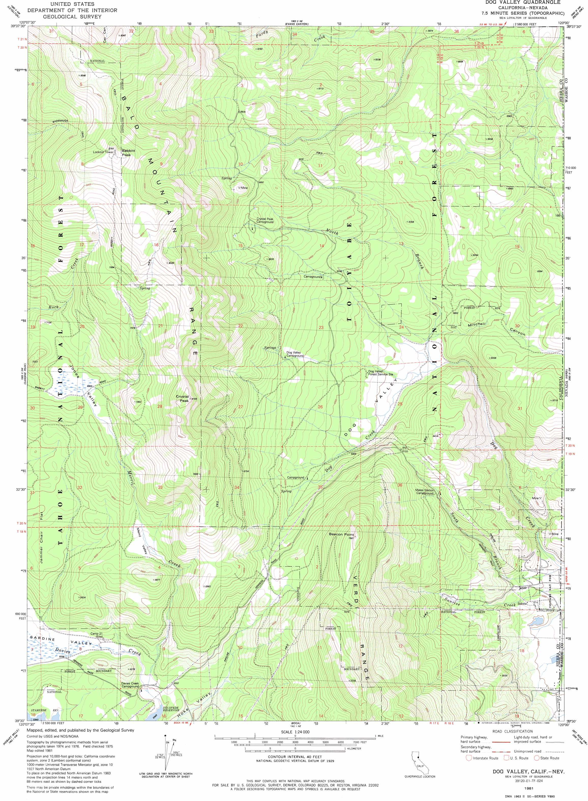
USGS Topo Quad 39120e1 - 1:24,000 scale
| Topo Map Name: | Dog Valley |
| USGS Topo Quad ID: | 39120e1 |
| Print Size: | ca. 21 1/4" wide x 27" high |
| Southeast Coordinates: | 39.5° N latitude / 120° W longitude |
| Map Center Coordinates: | 39.5625° N latitude / 120.0625° W longitude |
| U.S. States: | CA, NV |
| Filename: | o39120e1.jpg |
| Download Map JPG Image: | Dog Valley topo map 1:24,000 scale |
| Map Type: | Topographic |
| Topo Series: | 7.5´ |
| Map Scale: | 1:24,000 |
| Source of Map Images: | United States Geological Survey (USGS) |
| Alternate Map Versions: |
Dog Valley CA 1981, updated 1981 Download PDF Buy paper map Dog Valley CA 1981, updated 1981 Download PDF Buy paper map Dog Valley CA 1981, updated 1986 Download PDF Buy paper map Dog Valley CA 2000, updated 2003 Download PDF Buy paper map Dog Valley CA 2012 Download PDF Buy paper map Dog Valley CA 2015 Download PDF Buy paper map |
| FStopo: | US Forest Service topo Dog Valley is available: Download FStopo PDF Download FStopo TIF |
1:24,000 Topo Quads surrounding Dog Valley
Reconnaissance Peak |
Chilcoot |
Beckwourth Pass |
Granite Peak |
Bedell Flat |
Antelope Valley |
Loyalton |
Evans Canyon |
Reno Nw |
Reno Ne |
Sierraville |
Sardine Peak |
Dog Valley |
Verdi |
Reno |
Independence Lake |
Hobart Mills |
Boca |
Mount Rose Nw |
Mount Rose Ne |
Norden |
Truckee |
Martis Peak |
Mount Rose |
Washoe City |
> Back to 39120e1 at 1:100,000 scale
> Back to 39120a1 at 1:250,000 scale
> Back to U.S. Topo Maps home
Dog Valley topo map: Gazetteer
Dog Valley: Basins
Jones Valley elevation 2131m 6991′Merrill Valley elevation 2017m 6617′
Dog Valley: Canals
Coldron Ditch elevation 1497m 4911′Dog Valley: Dams
Sunrise 1290 Dam elevation 1524m 5000′Dog Valley: Flats
Jammer Chair Flat elevation 1972m 6469′Dog Valley: Parks
Babbit Peak Research Natural Area elevation 2542m 8339′Dog Valley: Populated Places
Verdi-Sierra Pines elevation 1565m 5134′Dog Valley: Ranges
Bald Mountain Range elevation 2601m 8533′Verdi Range elevation 2337m 7667′
Dog Valley: Streams
Merrill Creek elevation 1826m 5990′North Branch Dog Creek elevation 1735m 5692′
South Branch Dog Creek elevation 1500m 4921′
Dog Valley: Summits
Babbitt Peak elevation 2664m 8740′Beacon Point elevation 2284m 7493′
Crystal Peak elevation 2461m 8074′
Dog Valley: Trails
Donner Trail elevation 1805m 5921′Dog Valley: Valleys
Dog Valley elevation 1744m 5721′Mitchell Canyon elevation 1755m 5757′
Sardine Valley elevation 1844m 6049′
Dog Valley digital topo map on disk
Buy this Dog Valley topo map showing relief, roads, GPS coordinates and other geographical features, as a high-resolution digital map file on DVD: