Onion Valley Topo Map California
To zoom in, hover over the map of Onion Valley
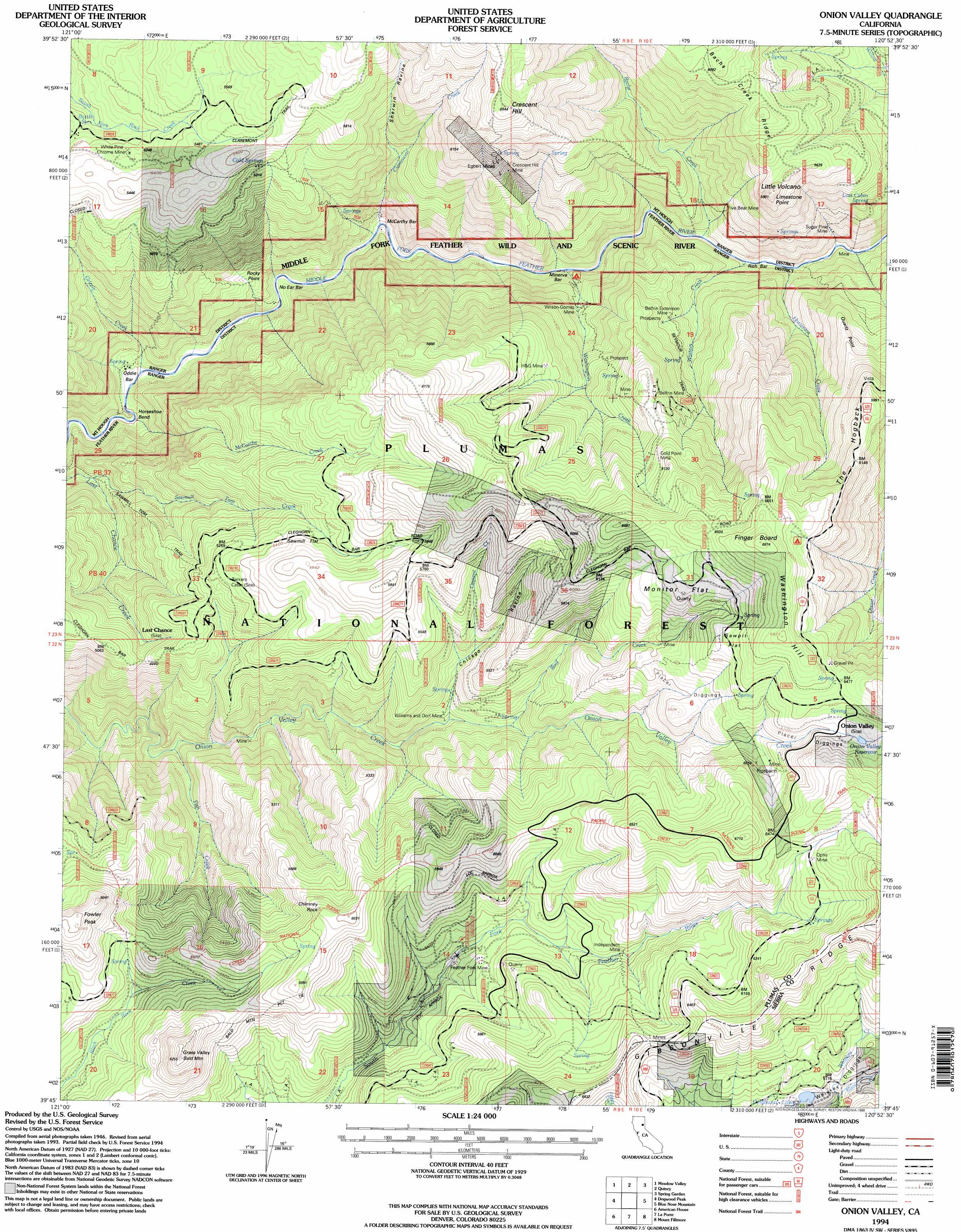
USGS Topo Quad 39120g8 - 1:24,000 scale
| Topo Map Name: | Onion Valley |
| USGS Topo Quad ID: | 39120g8 |
| Print Size: | ca. 21 1/4" wide x 27" high |
| Southeast Coordinates: | 39.75° N latitude / 120.875° W longitude |
| Map Center Coordinates: | 39.8125° N latitude / 120.9375° W longitude |
| U.S. State: | CA |
| Filename: | o39120g8.jpg |
| Download Map JPG Image: | Onion Valley topo map 1:24,000 scale |
| Map Type: | Topographic |
| Topo Series: | 7.5´ |
| Map Scale: | 1:24,000 |
| Source of Map Images: | United States Geological Survey (USGS) |
| Alternate Map Versions: |
Onion Valley CA 1950, updated 1958 Download PDF Buy paper map Onion Valley CA 1950, updated 1966 Download PDF Buy paper map Onion Valley CA 1950, updated 1978 Download PDF Buy paper map Onion Valley CA 1951 Download PDF Buy paper map Onion Valley CA 1994, updated 1998 Download PDF Buy paper map Onion Valley CA 2012 Download PDF Buy paper map Onion Valley CA 2015 Download PDF Buy paper map |
| FStopo: | US Forest Service topo Onion Valley is available: Download FStopo PDF Download FStopo TIF |
1:24,000 Topo Quads surrounding Onion Valley
Caribou |
Twain |
Crescent Mills |
Taylorsville |
Genesee Valley |
Bucks Lake |
Meadow Valley |
Quincy |
Spring Garden |
Mount Ingalls |
Haskins Valley |
Dogwood Peak |
Onion Valley |
Blue Nose Mountain |
Johnsville |
Cascade |
American House |
La Porte |
Mount Fillmore |
Gold Lake |
Clipper Mills |
Strawberry Valley |
Goodyears Bar |
Downieville |
Sierra City |
> Back to 39120e1 at 1:100,000 scale
> Back to 39120a1 at 1:250,000 scale
> Back to U.S. Topo Maps home
Onion Valley topo map: Gazetteer
Onion Valley: Bars
Minerva Bar elevation 1124m 3687′Rich Bar elevation 1143m 3750′
Onion Valley: Bends
Horseshoe Bend elevation 979m 3211′McCarthy Bar elevation 1079m 3540′
No Ear Bar elevation 1062m 3484′
Oddie Bar elevation 987m 3238′
Onion Valley: Capes
Quartz Point elevation 1625m 5331′Onion Valley: Cliffs
Limestone Point elevation 1687m 5534′Rocky Point elevation 1112m 3648′
Onion Valley: Flats
Monitor Flat elevation 1905m 6250′Sawmill Flat elevation 1676m 5498′
Sawpit Flat elevation 1942m 6371′
Onion Valley: Lakes
Delahunty Lake elevation 1749m 5738′Onion Valley: Mines
Belfrin Extension Mine elevation 1396m 4580′Belfrin Mine elevation 1520m 4986′
Crescent Hill Mine elevation 1637m 5370′
Egbert Mines elevation 1724m 5656′
Feather Fork Mine elevation 1614m 5295′
Five Bear Mine elevation 1330m 4363′
Gold Point Mine elevation 1763m 5784′
H and G Mine elevation 1596m 5236′
Independent Mine elevation 1687m 5534′
Sugar Pine Mine elevation 1243m 4078′
Whiskey Diggings elevation 1752m 5748′
White Pine Chrome Mine elevation 1594m 5229′
Williams and Dorf Mine elevation 1388m 4553′
Wilson-Gomez Mine elevation 1267m 4156′
Onion Valley: Reservoirs
Onion Valley Reservoir elevation 1913m 6276′Onion Valley: Ridges
Gibsonville Ridge elevation 1992m 6535′The Hogback elevation 1869m 6131′
Onion Valley: Springs
Cold Springs elevation 1641m 5383′Lost Cabin Spring elevation 1430m 4691′
Onion Valley: Streams
Bachs Creek elevation 1137m 3730′Bird Creek elevation 1443m 4734′
Claremont Creek elevation 1070m 3510′
Fish Creek elevation 1126m 3694′
Grizzly Creek elevation 985m 3231′
Hottentot Creek elevation 1145m 3756′
McCarthy Creek elevation 972m 3188′
Sawmill Tom Creek elevation 1080m 3543′
Washington Creek elevation 1113m 3651′
Whiskey Creek elevation 1734m 5688′
Winters Creek elevation 1144m 3753′
Onion Valley: Summits
Chimney Rock elevation 1830m 6003′Crescent Hill elevation 1985m 6512′
Finger Board elevation 2093m 6866′
Fowler Peak elevation 1843m 6046′
Grass Valley Bald Mountain elevation 1908m 6259′
Little Volcano elevation 1765m 5790′
Washington Hill elevation 2079m 6820′
Onion Valley: Trails
Bear Wallow Trail elevation 1656m 5433′Butte Bar Trail elevation 1648m 5406′
Cleghorn Bar Trail elevation 1505m 4937′
Finger Board Trail elevation 1712m 5616′
Fowler Peak Trail elevation 1812m 5944′
Sawmill Tom Trail elevation 1417m 4648′
Onion Valley: Valleys
Chicago Ravine elevation 1418m 4652′Sherwin Ravine elevation 1420m 4658′
Onion Valley digital topo map on disk
Buy this Onion Valley topo map showing relief, roads, GPS coordinates and other geographical features, as a high-resolution digital map file on DVD: