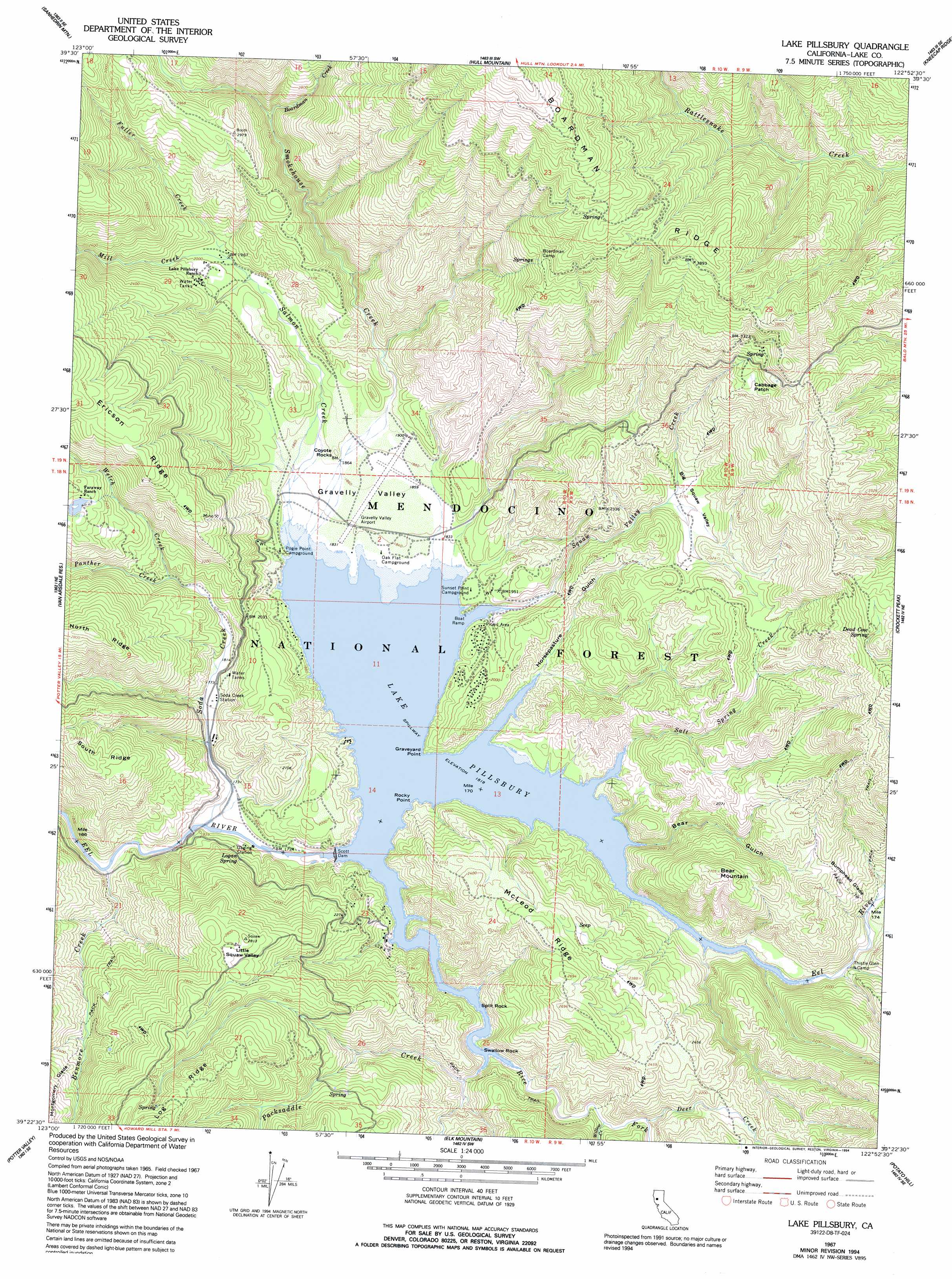
Lake Pillsbury Topo Map California
To zoom in, hover over the map of Lake Pillsbury
USGS Topo Quad 39122d8 - 1:24,000 scale
| Topo Map Name: | Lake Pillsbury |
| USGS Topo Quad ID: | 39122d8 |
| Print Size: | ca. 21 1/4" wide x 27" high |
| Southeast Coordinates: | 39.375° N latitude / 122.875° W longitude |
| Map Center Coordinates: | 39.4375° N latitude / 122.9375° W longitude |
| U.S. State: | CA |
| Filename: | o39122d8.jpg |
| Download Map JPG Image: | Lake Pillsbury topo map 1:24,000 scale |
| Map Type: | Topographic |
| Topo Series: | 7.5´ |
| Map Scale: | 1:24,000 |
| Source of Map Images: | United States Geological Survey (USGS) |
| Alternate Map Versions: |
Lake Pillsbury CA 1967, updated 1969 Download PDF Buy paper map Lake Pillsbury CA 1967, updated 1980 Download PDF Buy paper map Lake Pillsbury CA 1967, updated 1986 Download PDF Buy paper map Lake Pillsbury CA 1967, updated 1994 Download PDF Buy paper map Lake Pillsbury CA 1996, updated 2001 Download PDF Buy paper map Lake Pillsbury CA 2012 Download PDF Buy paper map Lake Pillsbury CA 2015 Download PDF Buy paper map |
| FStopo: | US Forest Service topo Lake Pillsbury is available: Download FStopo PDF Download FStopo TIF |
1:24,000 Topo Quads surrounding Lake Pillsbury
Jamison Ridge |
Thatcher Ridge |
Plaskett Ridge |
Plaskett Meadows |
Alder Springs |
Brushy Mountain |
Sanhedrin Mountain |
Hull Mountain |
Kneecap Ridge |
Felkner Hill |
Foster Mountain |
Van Arsdale Reservoir |
Lake Pillsbury |
Crockett Peak |
Saint John Mountain |
Redwood Valley |
Potter Valley |
Elk Mountain |
Potato Hill |
Fouts Springs |
Ukiah |
Cow Mountain |
Upper Lake |
Bartlett Mountain |
Bartlett Springs |
> Back to 39122a1 at 1:100,000 scale
> Back to 39122a1 at 1:250,000 scale
> Back to U.S. Topo Maps home
Lake Pillsbury topo map: Gazetteer
Lake Pillsbury: Airports
Gravelly Valley Airport elevation 567m 1860′Lake Pillsbury: Basins
Gravelly Valley elevation 568m 1863′Little Squaw Valley elevation 830m 2723′
Lake Pillsbury: Capes
Graveyard Point elevation 575m 1886′Rocky Point elevation 572m 1876′
Swallow Rock elevation 555m 1820′
Lake Pillsbury: Dams
Scott Dam elevation 555m 1820′Lake Pillsbury: Flats
Bumphead Glade elevation 648m 2125′Cabbage Patch elevation 939m 3080′
Montgomery Glade elevation 793m 2601′
Lake Pillsbury: Islands
Split Rock elevation 555m 1820′Lake Pillsbury: Populated Places
Rice Fork Summer Homes elevation 581m 1906′Lake Pillsbury: Reservoirs
Lake Pillsbury elevation 555m 1820′Lake Pillsbury: Ridges
Boardman Ridge elevation 1298m 4258′Log Ridge elevation 957m 3139′
McLeod Ridge elevation 784m 2572′
North Ridge elevation 881m 2890′
South Ridge elevation 830m 2723′
Lake Pillsbury: Springs
Dead Cow Spring elevation 987m 3238′Logan Spring elevation 586m 1922′
Lake Pillsbury: Streams
Benmore Creek elevation 516m 1692′Boardman Creek elevation 721m 2365′
Deer Creek elevation 570m 1870′
Fuller Creek elevation 604m 1981′
Mill Creek elevation 601m 1971′
Packsaddle Creek elevation 562m 1843′
Panther Creek elevation 563m 1847′
Rice Fork elevation 556m 1824′
Salmon Creek elevation 560m 1837′
Salt Spring Creek elevation 565m 1853′
Smokehouse Creek elevation 559m 1833′
Soda Creek elevation 519m 1702′
Squaw Valley Creek elevation 556m 1824′
Thistle Glade Creek elevation 560m 1837′
Welch Creek elevation 563m 1847′
Willow Creek elevation 566m 1856′
Lake Pillsbury: Summits
Bear Mountain elevation 822m 2696′Coyote Rocks elevation 581m 1906′
Lake Pillsbury: Valleys
Bear Gulch elevation 556m 1824′Big Squaw Valley elevation 683m 2240′
Horsepasture Gulch elevation 561m 1840′
Lake Pillsbury digital topo map on disk
Buy this Lake Pillsbury topo map showing relief, roads, GPS coordinates and other geographical features, as a high-resolution digital map file on DVD: