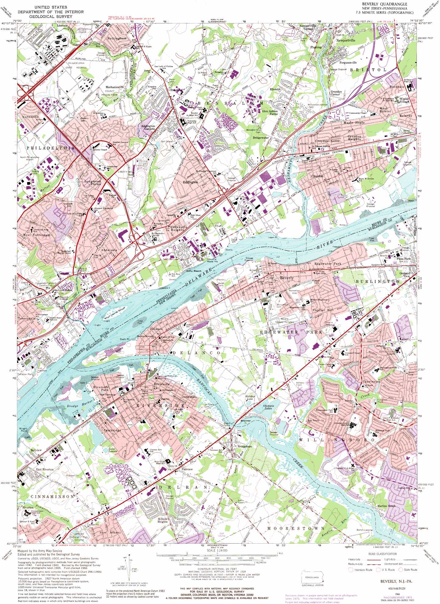
Beverly Topo Map Pennsylvania
To zoom in, hover over the map of Beverly
USGS Topo Quad 40074a8 - 1:24,000 scale
| Topo Map Name: | Beverly |
| USGS Topo Quad ID: | 40074a8 |
| Print Size: | ca. 21 1/4" wide x 27" high |
| Southeast Coordinates: | 40° N latitude / 74.875° W longitude |
| Map Center Coordinates: | 40.0625° N latitude / 74.9375° W longitude |
| U.S. States: | PA, NJ |
| Filename: | o40074a8.jpg |
| Download Map JPG Image: | Beverly topo map 1:24,000 scale |
| Map Type: | Topographic |
| Topo Series: | 7.5´ |
| Map Scale: | 1:24,000 |
| Source of Map Images: | United States Geological Survey (USGS) |
| Alternate Map Versions: |
Beverly NJ 1947 Download PDF Buy paper map Beverly NJ 1955, updated 1957 Download PDF Buy paper map Beverly NJ 1955, updated 1957 Download PDF Buy paper map Beverly NJ 1955, updated 1964 Download PDF Buy paper map Beverly NJ 1966, updated 1969 Download PDF Buy paper map Beverly NJ 1966, updated 1974 Download PDF Buy paper map Beverly NJ 1966, updated 1977 Download PDF Buy paper map Beverly NJ 1966, updated 1990 Download PDF Buy paper map Beverly NJ 1966, updated 1990 Download PDF Buy paper map Beverly NJ 1995, updated 2000 Download PDF Buy paper map Beverly NJ 2011 Download PDF Buy paper map Beverly NJ 2014 Download PDF Buy paper map Beverly NJ 2016 Download PDF Buy paper map |
1:24,000 Topo Quads surrounding Beverly
Doylestown |
Buckingham |
Lambertville |
Pennington |
Princeton |
Ambler |
Hatboro |
Langhorne |
Trenton West |
Trenton East |
Germantown |
Frankford |
Beverly |
Bristol |
Columbus |
Philadelphia |
Camden |
Moorestown |
Mount Holly |
Pemberton |
Woodbury |
Runnemede |
Clementon |
Medford Lakes |
Indian Mills |
> Back to 40074a1 at 1:100,000 scale
> Back to 40074a1 at 1:250,000 scale
> Back to U.S. Topo Maps home
Beverly topo map: Gazetteer
Beverly: Airports
Copter-Liberty Bell Airport elevation 14m 45′Lactona Corporation Airport elevation 30m 98′
MacMillan Helistop elevation 11m 36′
Rancocas Hospital Heliport elevation 13m 42′
Ronson-Delanco Helistop elevation 0m 0′
Sons Heliport elevation 12m 39′
Wes-Port Equipment Park Airport elevation 5m 16′
Beverly: Bars
Mud Island Shoal elevation 2m 6′Beverly: Bays
Dredge Harbor elevation 0m 0′Riverton Cove elevation 5m 16′
Wright Cove elevation 4m 13′
Beverly: Capes
Diehl Point elevation 1m 3′Logan Point elevation 1m 3′
Plum Point elevation 0m 0′
Wright Point elevation 4m 13′
Beverly: Channels
Beverly Channel elevation 0m 0′Beverly Channel elevation 0m 0′
Edgewater Channel elevation 1m 3′
Edgewater Channel elevation 1m 3′
Enterprise Range elevation 0m 0′
Enterprise Range elevation 0m 0′
Mud Island Range elevation 0m 0′
Mud Island Range elevation 0m 0′
Torresdale Range elevation 0m 0′
Torresdale Range elevation 0m 0′
Beverly: Crossings
Interchange 35 elevation 17m 55′Interchange 36 elevation 14m 45′
Interchange 37 elevation 11m 36′
Interchange 40 elevation 18m 59′
Beverly: Islands
Fenton Island elevation 1m 3′Hawk Island elevation 6m 19′
Beverly: Lakes
Olympia Lakes elevation 4m 13′Swedes Lake elevation 1m 3′
Beverly: Parks
Benjamin Rush State Park elevation 36m 118′Delaware River Access Area elevation 0m 0′
Liberty Bell Park elevation 26m 85′
Neshaminy State Park elevation 8m 26′
Pleasant Hill Park elevation 6m 19′
Beverly: Populated Places
Academy Garden elevation 10m 32′Andalusia elevation 19m 62′
Belardy elevation 11m 36′
Bellview elevation 4m 13′
Bensalem elevation 30m 98′
Beverly elevation 7m 22′
Borton Landing elevation 4m 13′
Bridgeboro elevation 14m 45′
Bridgewater elevation 19m 62′
Brookwood elevation 25m 82′
Buckingham Park elevation 12m 39′
Byberry elevation 27m 88′
Byberry elevation 38m 124′
Cambridge elevation 6m 19′
Capitol Hill elevation 12m 39′
Carriage Stop elevation 25m 82′
Centre Plaza Shopping Center elevation 30m 98′
Charleston elevation 8m 26′
Chestnut Wood Village elevation 9m 29′
Cooperstown elevation 12m 39′
Cornwell elevation 18m 59′
Cornwells Heights elevation 24m 78′
Cornwells Manor elevation 12m 39′
Country Club Ridge elevation 15m 49′
Crestmont Farms elevation 26m 85′
Croydon elevation 6m 19′
Croydon Acres elevation 7m 22′
Croydon Heights elevation 8m 26′
Delaire Landing elevation 7m 22′
Delanco elevation 6m 19′
Devon Close elevation 6m 19′
East Riverton elevation 4m 13′
Echo Beach elevation 6m 19′
Echo Reach elevation 6m 19′
Eddington elevation 19m 62′
Eddington Gardens elevation 29m 95′
Eddington Park elevation 30m 98′
Edgewater Park elevation 7m 22′
Ellerslie elevation 23m 75′
Fairview elevation 22m 72′
Fergusonville elevation 11m 36′
Flushing elevation 12m 39′
Franklin Park elevation 12m 39′
Garfield Park elevation 13m 42′
Glen Ashton Farms elevation 24m 78′
Grundys Corner elevation 5m 16′
Kearney elevation 17m 55′
Longmead Farms elevation 30m 98′
Maple Shade elevation 8m 26′
Martins Beach elevation 5m 16′
Mechanicsville elevation 23m 75′
Milbrook elevation 19m 62′
Millbrook Park elevation 10m 32′
Millside Heights elevation 13m 42′
Modena Park elevation 32m 104′
Morrell Park elevation 20m 65′
New Albany elevation 13m 42′
Newportville elevation 18m 59′
Newportville Terrace elevation 15m 49′
Normandy elevation 40m 131′
Nottingham elevation 35m 114′
Parkwood Manor elevation 30m 98′
Pennypacker Park elevation 14m 45′
Plaza Park elevation 4m 13′
Riverside elevation 8m 26′
Riverside Park elevation 4m 13′
Riverton elevation 10m 32′
Rockdale elevation 11m 36′
Sharper elevation 1m 3′
Skin Corner elevation 14m 45′
Somerset Park elevation 10m 32′
Stanwood elevation 30m 98′
Torresdale Manor elevation 6m 19′
Twin Hill Park elevation 11m 36′
Union Landing elevation 5m 16′
West Bristol elevation 9m 29′
West Torresdale elevation 20m 65′
Beverly: Post Offices
Andalusia Post Office (historical) elevation 19m 62′Bridgewater Post Office (historical) elevation 19m 62′
Cornwell Heights Post Office elevation 18m 59′
Cornwells Heights Post Office (historical) elevation 24m 78′
Croydon Post Office (historical) elevation 6m 19′
Holmesburg Post Office elevation 19m 62′
Maud Post Office (historical) elevation 20m 65′
Torresdale Post Office elevation 30m 98′
Willingboro Post Office elevation 23m 75′
Beverly: Reservoirs
Holiday Lake elevation 6m 19′Lake Lonnie elevation 3m 9′
Lake Louis elevation 4m 13′
Beverly: Streams
Black Lake Run elevation 22m 72′Boundary Creek elevation 0m 0′
Byberry Creek elevation 6m 19′
Kendles Run elevation 0m 0′
Laurel Run elevation 0m 0′
Mill Creek elevation 2m 6′
Neshaminy Creek elevation 1m 3′
Poquessing Creek elevation 5m 16′
Rancocas Creek elevation 0m 0′
South Branch Mill Creek elevation 6m 19′
Swede Run elevation 3m 9′
Walton Run elevation 22m 72′
Beverly digital topo map on disk
Buy this Beverly topo map showing relief, roads, GPS coordinates and other geographical features, as a high-resolution digital map file on DVD:
Atlantic Coast (NY, NJ, PA, DE, MD, VA, NC)
Buy digital topo maps: Atlantic Coast (NY, NJ, PA, DE, MD, VA, NC)
 map DVD")