Indian Peaks Topo Map Utah
To zoom in, hover over the map of Indian Peaks
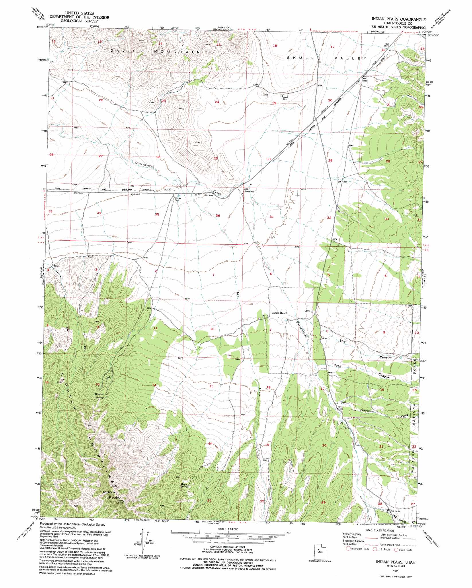
USGS Topo Quad 40112a6 - 1:24,000 scale
| Topo Map Name: | Indian Peaks |
| USGS Topo Quad ID: | 40112a6 |
| Print Size: | ca. 21 1/4" wide x 27" high |
| Southeast Coordinates: | 40° N latitude / 112.625° W longitude |
| Map Center Coordinates: | 40.0625° N latitude / 112.6875° W longitude |
| U.S. State: | UT |
| Filename: | o40112a6.jpg |
| Download Map JPG Image: | Indian Peaks topo map 1:24,000 scale |
| Map Type: | Topographic |
| Topo Series: | 7.5´ |
| Map Scale: | 1:24,000 |
| Source of Map Images: | United States Geological Survey (USGS) |
| Alternate Map Versions: |
Indian Peaks UT 1955, updated 1956 Download PDF Buy paper map Indian Peaks UT 1955, updated 1977 Download PDF Buy paper map Indian Peaks UT 1993, updated 1993 Download PDF Buy paper map Indian Peaks UT 1998, updated 2002 Download PDF Buy paper map Indian Peaks UT 2011 Download PDF Buy paper map Indian Peaks UT 2014 Download PDF Buy paper map |
| FStopo: | US Forest Service topo Indian Peaks is available: Download FStopo PDF Download FStopo TIF |
1:24,000 Topo Quads surrounding Indian Peaks
Tabbys Peak Sw |
Tabbys Peak Se |
Terra |
Johnson Pass |
Saint John |
Camels Back Ridge Nw |
Camels Back Ridge Ne |
Davis Knolls |
Onaqui Mountains South |
Faust |
Camels Back Ridge Sw |
Simpson Springs |
Indian Peaks |
Lookout Pass |
Vernon |
Table Mountain |
Coyote Springs |
Indian Springs |
Erickson Knoll |
Dutch Peak |
Keg Pass |
Keg Mountain Ranch |
Erickson Wash Sw |
Desert Mountain Pass |
Cherry Creek |
> Back to 40112a1 at 1:100,000 scale
> Back to 40112a1 at 1:250,000 scale
> Back to U.S. Topo Maps home
Indian Peaks topo map: Gazetteer
Indian Peaks: Springs
Toms Spring elevation 1952m 6404′Winter Springs elevation 1843m 6046′
Indian Peaks: Streams
Lee Creek elevation 1525m 5003′West Government Creek elevation 1682m 5518′
West Oak Brush Creek elevation 1744m 5721′
Indian Peaks: Summits
Davis Mountain elevation 1886m 6187′Indian Peaks elevation 2556m 8385′
Indian Peaks: Valleys
Dry Canyon elevation 1746m 5728′Lee Canyon elevation 1732m 5682′
Rock Canyon elevation 1764m 5787′
Indian Peaks digital topo map on disk
Buy this Indian Peaks topo map showing relief, roads, GPS coordinates and other geographical features, as a high-resolution digital map file on DVD: