Dinsmore Topo Map California
To zoom in, hover over the map of Dinsmore
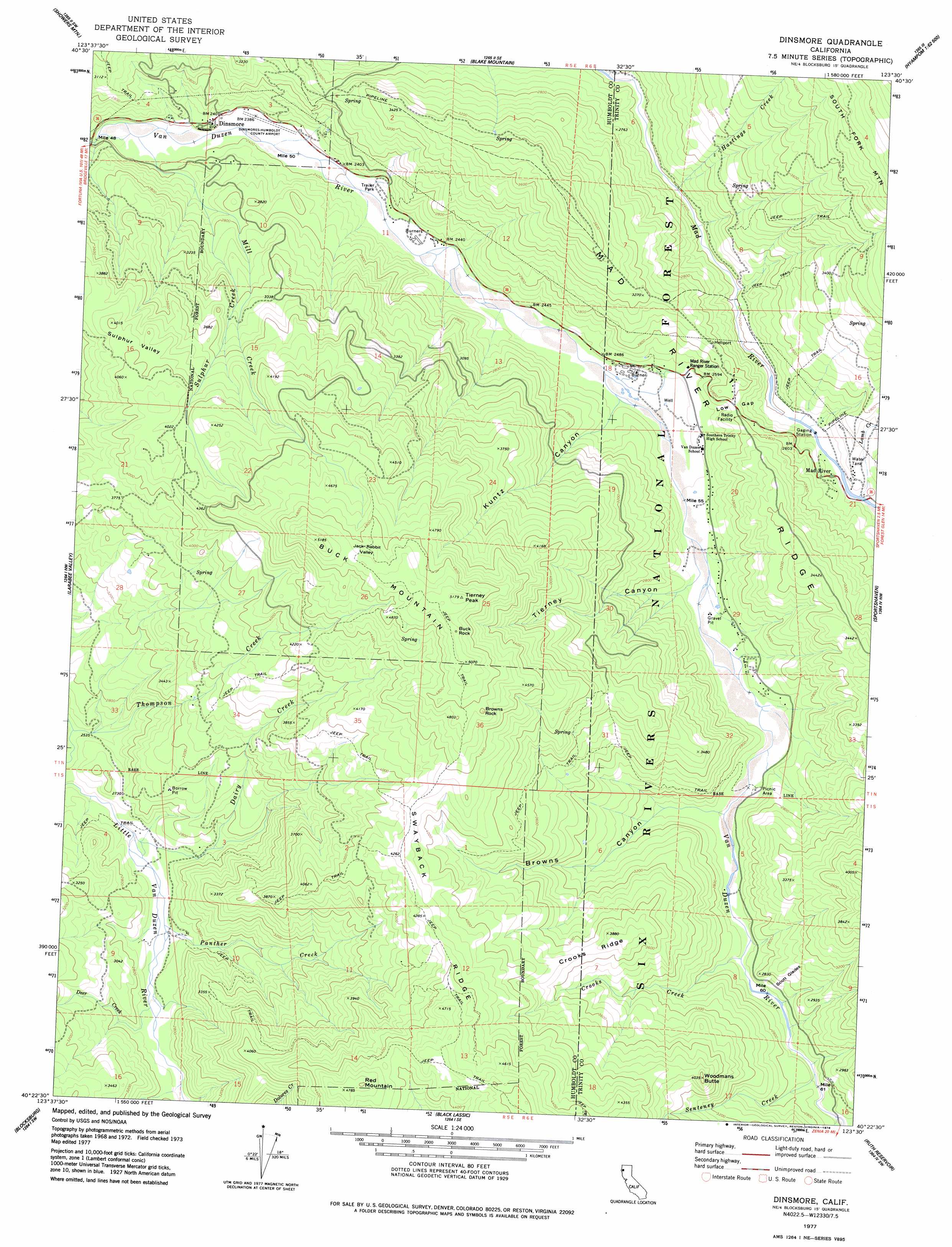
USGS Topo Quad 40123d5 - 1:24,000 scale
| Topo Map Name: | Dinsmore |
| USGS Topo Quad ID: | 40123d5 |
| Print Size: | ca. 21 1/4" wide x 27" high |
| Southeast Coordinates: | 40.375° N latitude / 123.5° W longitude |
| Map Center Coordinates: | 40.4375° N latitude / 123.5625° W longitude |
| U.S. State: | CA |
| Filename: | o40123d5.jpg |
| Download Map JPG Image: | Dinsmore topo map 1:24,000 scale |
| Map Type: | Topographic |
| Topo Series: | 7.5´ |
| Map Scale: | 1:24,000 |
| Source of Map Images: | United States Geological Survey (USGS) |
| Alternate Map Versions: |
Dinsmore CA 1977, updated 1978 Download PDF Buy paper map Dinsmore CA 1977, updated 1978 Download PDF Buy paper map Dinsmore CA 1997, updated 2001 Download PDF Buy paper map Dinsmore CA 2012 Download PDF Buy paper map Dinsmore CA 2015 Download PDF Buy paper map |
| FStopo: | US Forest Service topo Dinsmore is available: Download FStopo PDF Download FStopo TIF |
1:24,000 Topo Quads surrounding Dinsmore
Mad River Buttes |
Board Camp Mountain |
Sims Mountain |
Hyampom Mountain |
Big Bar |
Yager Junction |
Showers Mountain |
Blake Mountain |
Hyampom |
Halfway Ridge |
Bridgeville |
Larabee Valley |
Dinsmore |
Sportshaven |
Naufus Creek |
Myers Flat |
Blocksburg |
Black Lassic |
Ruth Lake |
Forest Glen |
Miranda |
Fort Seward |
Alderpoint |
Zenia |
Shannon Butte |
> Back to 40123a1 at 1:100,000 scale
> Back to 40122a1 at 1:250,000 scale
> Back to U.S. Topo Maps home
Dinsmore topo map: Gazetteer
Dinsmore: Airports
Dinsmore Airport elevation 729m 2391′Dinsmore: Basins
Sulphur Valley elevation 1207m 3959′Dinsmore: Flats
Scott Glades elevation 861m 2824′Dinsmore: Gaps
Jack Rabbit Valley elevation 1481m 4858′Low Gap elevation 838m 2749′
Dinsmore: Pillars
Browns Rock elevation 1452m 4763′Buck Rock elevation 1554m 5098′
Dinsmore: Populated Places
Dinsmore elevation 736m 2414′Dinsmore: Ridges
Crooks Ridge elevation 1131m 3710′Swayback Ridge elevation 1384m 4540′
Dinsmore: Streams
County Line Creek elevation 713m 2339′Crooks Creek elevation 803m 2634′
Dairy Creek elevation 783m 2568′
Deer Creek elevation 815m 2673′
Hastings Creek elevation 736m 2414′
Lamb Creek elevation 752m 2467′
Mill Creek elevation 721m 2365′
Panther Creek elevation 800m 2624′
Senteney Creek elevation 803m 2634′
Sulphur Creek elevation 793m 2601′
Dinsmore: Summits
Buck Mountain elevation 1567m 5141′Red Mountain elevation 1462m 4796′
Tierney Peak elevation 1568m 5144′
Woodmans Butte elevation 1215m 3986′
Dinsmore: Valleys
Browns Canyon elevation 782m 2565′Kuntz Canyon elevation 754m 2473′
Tierney Canyon elevation 769m 2522′
Dinsmore digital topo map on disk
Buy this Dinsmore topo map showing relief, roads, GPS coordinates and other geographical features, as a high-resolution digital map file on DVD: