Board Camp Mountain Topo Map California
To zoom in, hover over the map of Board Camp Mountain
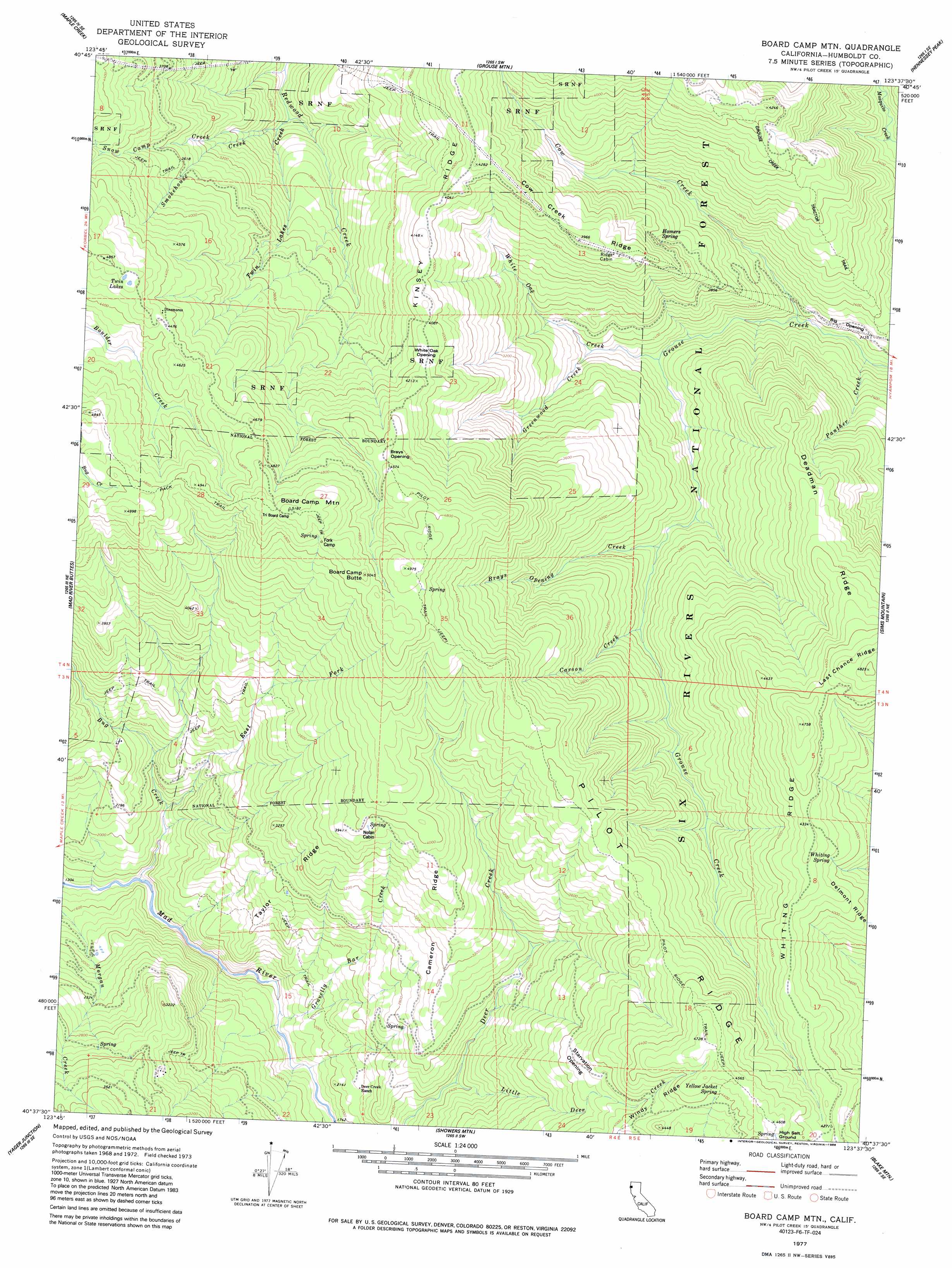
USGS Topo Quad 40123f6 - 1:24,000 scale
| Topo Map Name: | Board Camp Mountain |
| USGS Topo Quad ID: | 40123f6 |
| Print Size: | ca. 21 1/4" wide x 27" high |
| Southeast Coordinates: | 40.625° N latitude / 123.625° W longitude |
| Map Center Coordinates: | 40.6875° N latitude / 123.6875° W longitude |
| U.S. State: | CA |
| Filename: | o40123f6.jpg |
| Download Map JPG Image: | Board Camp Mountain topo map 1:24,000 scale |
| Map Type: | Topographic |
| Topo Series: | 7.5´ |
| Map Scale: | 1:24,000 |
| Source of Map Images: | United States Geological Survey (USGS) |
| Alternate Map Versions: |
Board Camp Mtn CA 1977, updated 1977 Download PDF Buy paper map Board Camp Mtn CA 1977, updated 1977 Download PDF Buy paper map Board Camp Mountain CA 1977, updated 1988 Download PDF Buy paper map Board Camp Mountain CA 1997, updated 2001 Download PDF Buy paper map Board Camp Mountain CA 2012 Download PDF Buy paper map Board Camp Mountain CA 2015 Download PDF Buy paper map |
| FStopo: | US Forest Service topo Board Camp Mountain is available: Download FStopo PDF Download FStopo TIF |
1:24,000 Topo Quads surrounding Board Camp Mountain
Blue Lake |
Lord-Ellis Summit |
Willow Creek |
Salyer |
Denny |
Korbel |
Maple Creek |
Grouse Mountain |
Hennessy Peak |
Ironside Mountain |
Iaqua Buttes |
Mad River Buttes |
Board Camp Mountain |
Sims Mountain |
Hyampom Mountain |
Owl Creek |
Yager Junction |
Showers Mountain |
Blake Mountain |
Hyampom |
Redcrest |
Bridgeville |
Larabee Valley |
Dinsmore |
Sportshaven |
> Back to 40123e1 at 1:100,000 scale
> Back to 40122a1 at 1:250,000 scale
> Back to U.S. Topo Maps home
Board Camp Mountain topo map: Gazetteer
Board Camp Mountain: Flats
Big Opening elevation 643m 2109′Brays Opening elevation 1373m 4504′
Starvation Opening elevation 1158m 3799′
White Oak Opening elevation 1250m 4101′
Board Camp Mountain: Lakes
Twin Lakes elevation 1434m 4704′Board Camp Mountain: Populated Places
Dinsmores elevation 1358m 4455′Board Camp Mountain: Ridges
Cameron Ridge elevation 1057m 3467′Cow Creek Ridge elevation 1177m 3861′
Deadman Ridge elevation 1196m 3923′
Delmont Ridge elevation 1242m 4074′
Kinsey Ridge elevation 1276m 4186′
Taylor Ridge elevation 857m 2811′
Whiting Ridge elevation 1306m 4284′
Board Camp Mountain: Springs
Homers Spring elevation 940m 3083′Whiting Spring elevation 1259m 4130′
Yellow Jacket Spring elevation 1336m 4383′
Board Camp Mountain: Streams
Brays Opening Creek elevation 776m 2545′Carson Creek elevation 823m 2700′
Cow Creek elevation 592m 1942′
East Fork Bug Creek elevation 529m 1735′
Gravelly Bar Creek elevation 504m 1653′
Greenwood Creek elevation 696m 2283′
Little Deer Creek elevation 706m 2316′
Panther Creek elevation 543m 1781′
Smokehouse Creek elevation 696m 2283′
Snow Camp Creek elevation 671m 2201′
Twin Lakes Creek elevation 654m 2145′
White Oak Creek elevation 645m 2116′
Board Camp Mountain: Summits
Board Camp Butte elevation 1541m 5055′Board Camp Mountain elevation 1567m 5141′
Board Camp Mountain: Trails
Grouse Creek Tractor Trail elevation 1041m 3415′Board Camp Mountain digital topo map on disk
Buy this Board Camp Mountain topo map showing relief, roads, GPS coordinates and other geographical features, as a high-resolution digital map file on DVD: