Bridgeville Topo Map California
To zoom in, hover over the map of Bridgeville
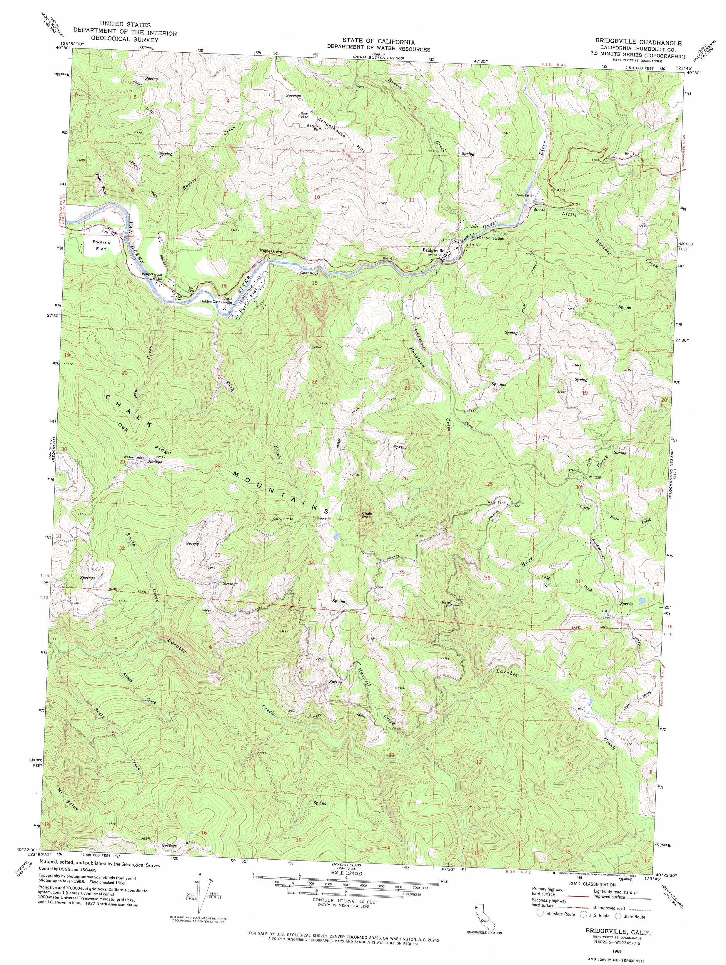
USGS Topo Quad 40123d7 - 1:24,000 scale
| Topo Map Name: | Bridgeville |
| USGS Topo Quad ID: | 40123d7 |
| Print Size: | ca. 21 1/4" wide x 27" high |
| Southeast Coordinates: | 40.375° N latitude / 123.75° W longitude |
| Map Center Coordinates: | 40.4375° N latitude / 123.8125° W longitude |
| U.S. State: | CA |
| Filename: | o40123d7.jpg |
| Download Map JPG Image: | Bridgeville topo map 1:24,000 scale |
| Map Type: | Topographic |
| Topo Series: | 7.5´ |
| Map Scale: | 1:24,000 |
| Source of Map Images: | United States Geological Survey (USGS) |
| Alternate Map Versions: |
Bridgeville CA 1969, updated 1974 Download PDF Buy paper map Bridgeville CA 1969, updated 1974 Download PDF Buy paper map Bridgeville CA 2012 Download PDF Buy paper map Bridgeville CA 2015 Download PDF Buy paper map |
1:24,000 Topo Quads surrounding Bridgeville
Mcwhinney Creek |
Iaqua Buttes |
Mad River Buttes |
Board Camp Mountain |
Sims Mountain |
Hydesville |
Owl Creek |
Yager Junction |
Showers Mountain |
Blake Mountain |
Scotia |
Redcrest |
Bridgeville |
Larabee Valley |
Dinsmore |
Bull Creek |
Weott |
Myers Flat |
Blocksburg |
Black Lassic |
Honeydew |
Ettersburg |
Miranda |
Fort Seward |
Alderpoint |
> Back to 40123a1 at 1:100,000 scale
> Back to 40122a1 at 1:250,000 scale
> Back to U.S. Topo Maps home
Bridgeville topo map: Gazetteer
Bridgeville: Bridges
Little Golden Gate Bridge elevation 136m 446′Bridgeville: Falls
Pepperwood Falls elevation 134m 439′Bridgeville: Flats
Petty Flat elevation 140m 459′Swains Flat elevation 154m 505′
Bridgeville: Pillars
Chalk Rock elevation 883m 2896′Goat Rock elevation 186m 610′
Bridgeville: Populated Places
Bridgeville elevation 194m 636′Maple Grove elevation 164m 538′
Bridgeville: Ranges
Chalk Mountains elevation 761m 2496′Bridgeville: Ridges
Oak Ridge elevation 788m 2585′Bridgeville: Slopes
Blue Slide elevation 288m 944′Bridgeville: Streams
Arnold Creek elevation 93m 305′Brown Creek elevation 211m 692′
Burr Creek elevation 240m 787′
Cold Creek elevation 278m 912′
Fish Creek elevation 141m 462′
Hoagland Creek elevation 176m 577′
Little Burr Creek elevation 317m 1040′
Little Larabee Creek elevation 196m 643′
Maxwell Creek elevation 217m 711′
Mill Creek elevation 264m 866′
Pip Creek elevation 133m 436′
Rogers Creek elevation 121m 396′
Scott Creek elevation 76m 249′
Smith Creek elevation 108m 354′
Bridgeville: Summits
Mount Baldy elevation 917m 3008′Schoolhouse Hill elevation 827m 2713′
Bridgeville digital topo map on disk
Buy this Bridgeville topo map showing relief, roads, GPS coordinates and other geographical features, as a high-resolution digital map file on DVD: