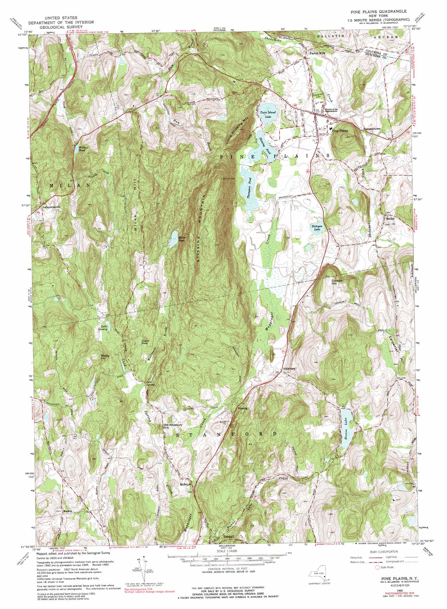
Pine Plains Topo Map New York
To zoom in, hover over the map of Pine Plains
USGS Topo Quad 41073h6 - 1:24,000 scale
| Topo Map Name: | Pine Plains |
| USGS Topo Quad ID: | 41073h6 |
| Print Size: | ca. 21 1/4" wide x 27" high |
| Southeast Coordinates: | 41.875° N latitude / 73.625° W longitude |
| Map Center Coordinates: | 41.9375° N latitude / 73.6875° W longitude |
| U.S. State: | NY |
| Filename: | o41073h6.jpg |
| Download Map JPG Image: | Pine Plains topo map 1:24,000 scale |
| Map Type: | Topographic |
| Topo Series: | 7.5´ |
| Map Scale: | 1:24,000 |
| Source of Map Images: | United States Geological Survey (USGS) |
| Alternate Map Versions: |
Pine Plains NY 1948 Download PDF Buy paper map Pine Plains NY 1960, updated 1963 Download PDF Buy paper map Pine Plains NY 1960, updated 1971 Download PDF Buy paper map Pine Plains NY 1960, updated 1989 Download PDF Buy paper map Pine Plains NY 1960, updated 1989 Download PDF Buy paper map Pine Plains NY 2010 Download PDF Buy paper map Pine Plains NY 2013 Download PDF Buy paper map Pine Plains NY 2016 Download PDF Buy paper map |
1:24,000 Topo Quads surrounding Pine Plains
Cementon |
Hudson South |
Claverack |
Hillsdale |
|
Saugerties |
Clermont |
Ancram |
Copake |
|
Kingston East |
Rock City |
Pine Plains |
Millerton |
Sharon |
Hyde Park |
Salt Point |
Millbrook |
Amenia |
Ellsworth |
Poughkeepsie |
Pleasant Valley |
Verbank |
Dover Plains |
Kent |
> Back to 41073e1 at 1:100,000 scale
> Back to 41072a1 at 1:250,000 scale
> Back to U.S. Topo Maps home
Pine Plains topo map: Gazetteer
Pine Plains: Lakes
Halcyon Lake elevation 142m 465′Hunns Lake elevation 234m 767′
Lake Geneva elevation 149m 488′
Miller Pond elevation 179m 587′
Stissing Pond elevation 137m 449′
Taylor Pond elevation 144m 472′
Thompson Pond elevation 137m 449′
Twin Island Lake elevation 138m 452′
Wilbur Pond elevation 157m 515′
Pine Plains: Parks
Lafayetteville State Multiple Use Area elevation 158m 518′Pine Plains: Populated Places
Attlebury elevation 146m 479′Bangall elevation 134m 439′
Bethel elevation 168m 551′
Hammertown elevation 135m 442′
Lafayetteville elevation 204m 669′
Market elevation 146m 479′
McIntyre elevation 116m 380′
Pachin Mills elevation 124m 406′
Pine Plains elevation 143m 469′
Stissing elevation 144m 472′
Pine Plains: Springs
Cold Spring elevation 139m 456′Pine Plains: Streams
Cold Spring Creek elevation 106m 347′Mountain Brook elevation 128m 419′
Pine Plains: Summits
Carpenter Hill elevation 309m 1013′Conklin Hill elevation 239m 784′
Hicks Hill elevation 299m 980′
Little Stissing Mountain elevation 321m 1053′
Old Attlebury Hill elevation 169m 554′
Shelly Hill elevation 207m 679′
Stissing Mountain elevation 425m 1394′
Pine Plains digital topo map on disk
Buy this Pine Plains topo map showing relief, roads, GPS coordinates and other geographical features, as a high-resolution digital map file on DVD:
New York, Vermont, Connecticut & Western Massachusetts
Buy digital topo maps: New York, Vermont, Connecticut & Western Massachusetts