Lansing North Topo Map Michigan
To zoom in, hover over the map of Lansing North
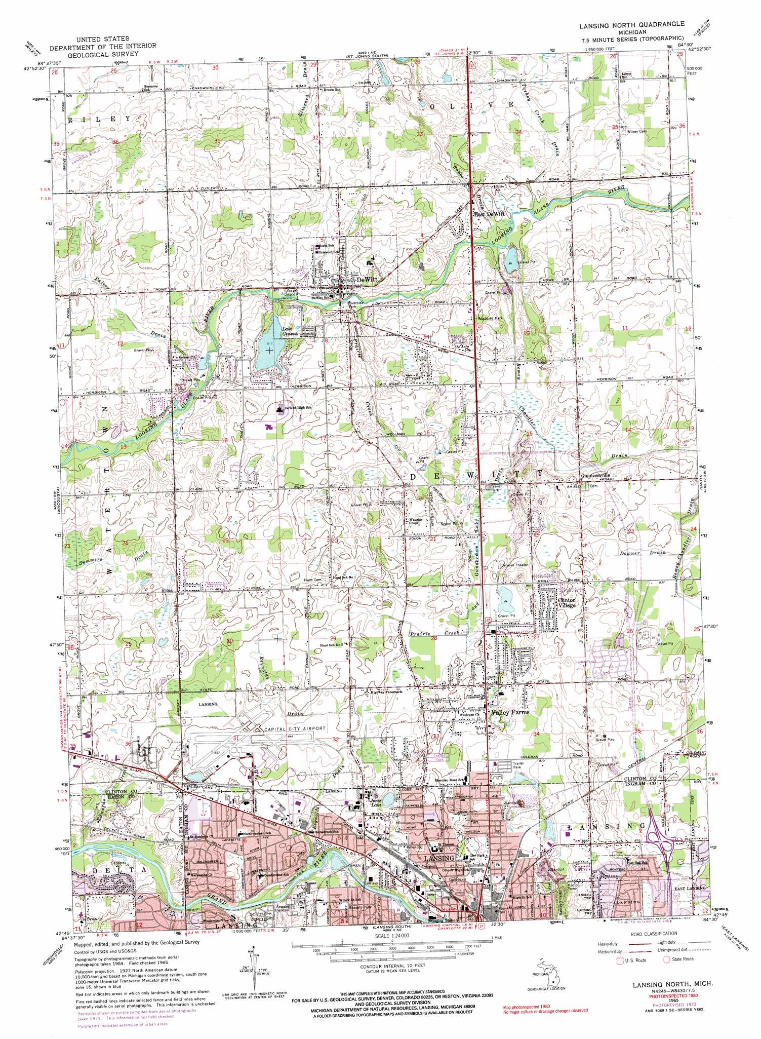
USGS Topo Quad 42084g5 - 1:24,000 scale
| Topo Map Name: | Lansing North |
| USGS Topo Quad ID: | 42084g5 |
| Print Size: | ca. 21 1/4" wide x 27" high |
| Southeast Coordinates: | 42.75° N latitude / 84.5° W longitude |
| Map Center Coordinates: | 42.8125° N latitude / 84.5625° W longitude |
| U.S. State: | MI |
| Filename: | o42084g5.jpg |
| Download Map JPG Image: | Lansing North topo map 1:24,000 scale |
| Map Type: | Topographic |
| Topo Series: | 7.5´ |
| Map Scale: | 1:24,000 |
| Source of Map Images: | United States Geological Survey (USGS) |
| Alternate Map Versions: |
Lansing North MI 1965, updated 1967 Download PDF Buy paper map Lansing North MI 1965, updated 1974 Download PDF Buy paper map Lansing North MI 2011 Download PDF Buy paper map Lansing North MI 2014 Download PDF Buy paper map Lansing North MI 2017 Download PDF Buy paper map |
1:24,000 Topo Quads surrounding Lansing North
Hubbardston |
Maple Rapids |
Saint Johns North |
Ovid West |
Ovid East |
Wasphalia |
Riley |
Saint Johns South |
Price |
Laingsburg |
Eagle |
Wacousta |
Lansing North |
Bath |
Shaftsburg |
Needmore |
Dimondale |
Lansing South |
East Lansing |
Williamston |
Charlotte |
Eaton Rapids |
Aurelius |
Mason |
Dansville |
> Back to 42084e1 at 1:100,000 scale
> Back to 42084a1 at 1:250,000 scale
> Back to U.S. Topo Maps home
Lansing North topo map: Gazetteer
Lansing North: Airports
Capital City Airport elevation 259m 849′Lansing North: Canals
Downer Drain elevation 255m 836′Edwards Drain elevation 249m 816′
Faiver Drain elevation 248m 813′
Prairie Creek and Gunderman Lake Drain elevation 252m 826′
Reynolds Drain elevation 253m 830′
Rouse Drain elevation 243m 797′
Summers Drain elevation 249m 816′
Turkey Creek Drain elevation 247m 810′
Lansing North: Lakes
Jones Lake elevation 256m 839′Lake Geneva elevation 248m 813′
Lansing North: Parks
Bancroft Park elevation 269m 882′Bassett Park elevation 257m 843′
Delta Mills Schools Historical Marker elevation 261m 856′
Filley Park elevation 260m 853′
Gunnisonville Historical Marker elevation 262m 859′
Gunnisonville United Methodist Church Historical Marker elevation 262m 859′
Orla McGuire Park elevation 244m 800′
Padgett Park elevation 252m 826′
Philip Orin Parmelee Historical Marker elevation 259m 849′
Riverside Park elevation 243m 797′
Tecumseh Park elevation 247m 810′
Lansing North: Populated Places
Cadgewith Farms Mobile Home Park elevation 262m 859′Clinton Village elevation 265m 869′
DeWitt elevation 253m 830′
East DeWitt elevation 248m 813′
Gunnisonville elevation 260m 853′
King Arthur Mobile Home Park elevation 263m 862′
Kristana Mobile Home Park elevation 265m 869′
Rotunda Mobile Home Park elevation 266m 872′
Valley Estates Mobile Home Park elevation 259m 849′
Valley Farms elevation 261m 856′
Lansing North: Post Offices
DeWitt Post Office elevation 256m 839′Gunnisonville Post Office (historical) elevation 260m 853′
Lansing North: Streams
Prairie Creek elevation 243m 797′Lansing North digital topo map on disk
Buy this Lansing North topo map showing relief, roads, GPS coordinates and other geographical features, as a high-resolution digital map file on DVD:
Northern Illinois, Northern Indiana & Southwestern Michigan
Buy digital topo maps: Northern Illinois, Northern Indiana & Southwestern Michigan