Barrington Topo Map Illinois
To zoom in, hover over the map of Barrington
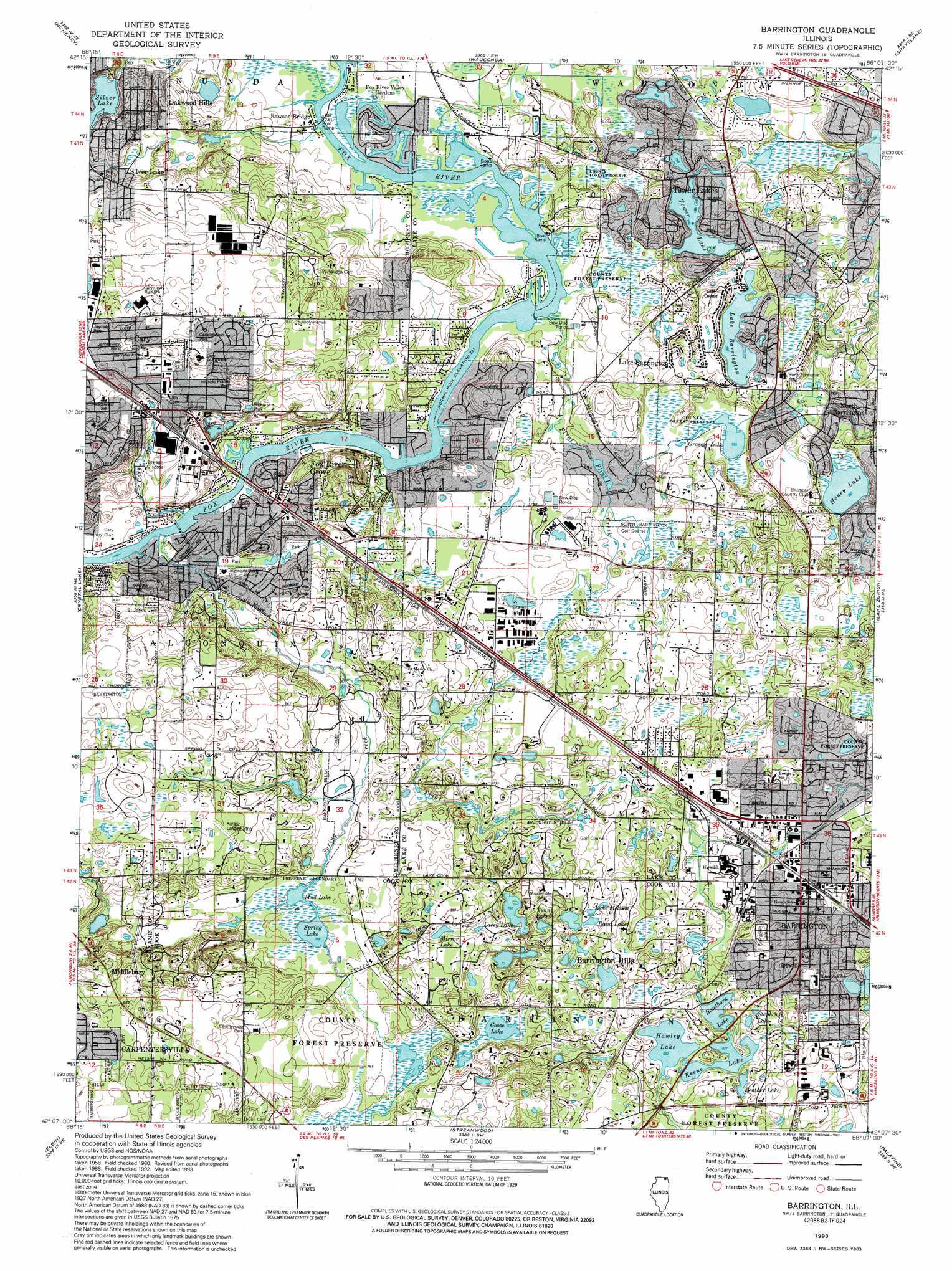
USGS Topo Quad 42088b2 - 1:24,000 scale
| Topo Map Name: | Barrington |
| USGS Topo Quad ID: | 42088b2 |
| Print Size: | ca. 21 1/4" wide x 27" high |
| Southeast Coordinates: | 42.125° N latitude / 88.125° W longitude |
| Map Center Coordinates: | 42.1875° N latitude / 88.1875° W longitude |
| U.S. State: | IL |
| Filename: | o42088b2.jpg |
| Download Map JPG Image: | Barrington topo map 1:24,000 scale |
| Map Type: | Topographic |
| Topo Series: | 7.5´ |
| Map Scale: | 1:24,000 |
| Source of Map Images: | United States Geological Survey (USGS) |
| Alternate Map Versions: |
Barrington IL 1960, updated 1962 Download PDF Buy paper map Barrington IL 1960, updated 1973 Download PDF Buy paper map Barrington IL 1960, updated 1981 Download PDF Buy paper map Barrington IL 1960, updated 1981 Download PDF Buy paper map Barrington IL 1993, updated 1993 Download PDF Buy paper map Barrington IL 2012 Download PDF Buy paper map Barrington IL 2015 Download PDF Buy paper map |
1:24,000 Topo Quads surrounding Barrington
Hebron |
Richmond |
Fox Lake |
Antioch |
Wadsworth |
Woodstock |
Mchenry |
Wauconda |
Grayslake |
Libertyville |
Huntley |
Crystal Lake |
Barrington |
Lake Zurich |
Wheeling |
Pingree Grove |
Elgin |
Streamwood |
Palatine |
Arlington Heights |
Elburn |
Geneva |
West Chicago |
Lombard |
Elmhurst |
> Back to 42088a1 at 1:100,000 scale
> Back to 42088a1 at 1:250,000 scale
> Back to U.S. Topo Maps home
Barrington topo map: Gazetteer
Barrington: Airports
Freier Airport elevation 228m 748′Good Shepherd Hospital Heliport elevation 239m 784′
Kuranz RLA Airport elevation 262m 859′
Barrington: Dams
Keene Lake Dam elevation 252m 826′North Tower Lake Dam elevation 233m 764′
Silver Lake Dam elevation 242m 793′
Timber Lake Dam elevation 236m 774′
Tower Lake Dam elevation 227m 744′
Barrington: Forests
Spring Creek Valley Forest Preserve elevation 238m 780′Barrington: Islands
Devils Island elevation 229m 751′Duck Island elevation 227m 744′
Play Island elevation 229m 751′
Rest Island elevation 229m 751′
Snake Island elevation 229m 751′
Barrington: Lakes
Dana Lake elevation 246m 807′Davlins Pond elevation 228m 748′
Goose Lake elevation 236m 774′
Grassy Lake elevation 230m 754′
Hawley Lake elevation 254m 833′
Hawthorn Lake elevation 249m 816′
Heather Lake elevation 255m 836′
Honey Lake elevation 240m 787′
Lacey Lake elevation 242m 793′
Lake Barrington elevation 239m 784′
Lake Melissa elevation 244m 800′
Mirror Lake elevation 255m 836′
Mud Lake elevation 234m 767′
North Tower Lake elevation 229m 751′
Spring Lake elevation 234m 767′
Stephanie Lake elevation 255m 836′
Twin Lakes elevation 255m 836′
Barrington: Parks
Aram Park elevation 245m 803′Barrington Bog Nature Preserve elevation 243m 797′
Barsumian Park elevation 243m 797′
Bates Fen Nature Preserve elevation 224m 734′
Bays Park elevation 231m 757′
Candlewood Park elevation 264m 866′
Cary Junior High Prairie Nature Preserve elevation 257m 843′
Countryside Park elevation 258m 846′
Eton Park elevation 234m 767′
Farm Trails North Nature Preserve elevation 225m 738′
Foxmoor Park elevation 230m 754′
Gorden Lewis Park elevation 230m 754′
Highlands Park elevation 227m 744′
Hillhurst Park elevation 240m 787′
Hillside Prairie Park elevation 265m 869′
Hussissian Park elevation 230m 754′
Jamesway Park elevation 257m 843′
Jaycee Park elevation 248m 813′
Langendorf Park elevation 248m 813′
Leonard Park elevation 246m 807′
Lions Park elevation 225m 738′
Murray Park elevation 230m 754′
North Side Park elevation 250m 820′
Roses Park elevation 229m 751′
South Beach Park elevation 247m 810′
Spring Lake Nature Preserve elevation 235m 770′
The Commons Recreation Park elevation 248m 813′
Tower Lakes Fen Nature Preserve elevation 224m 734′
Wagner Fen Nature Preserve elevation 224m 734′
Barrington: Populated Places
Barrington elevation 252m 826′Barrington Hills elevation 258m 846′
Cary elevation 251m 823′
Cuba elevation 245m 803′
Fox River Grove elevation 249m 816′
Lake Barrington elevation 245m 803′
Middlebury elevation 264m 866′
North Barrington elevation 241m 790′
Oakwood Hills elevation 252m 826′
Port Barrington elevation 225m 738′
Rawson Bridge elevation 225m 738′
Silver Lake elevation 253m 830′
Ski Hill elevation 266m 872′
Tower Lake elevation 238m 780′
Barrington: Reservoirs
Keene Lake elevation 252m 826′North Tower Lake elevation 233m 764′
Silver Lake elevation 242m 793′
Timber Lake elevation 236m 774′
Tower Lake elevation 227m 744′
Barrington: Streams
Cary Creek elevation 223m 731′Flint Creek elevation 224m 734′
North Flint Creek elevation 231m 757′
Spring Creek elevation 222m 728′
Barrington digital topo map on disk
Buy this Barrington topo map showing relief, roads, GPS coordinates and other geographical features, as a high-resolution digital map file on DVD:
Northern Illinois, Northern Indiana & Southwestern Michigan
Buy digital topo maps: Northern Illinois, Northern Indiana & Southwestern Michigan