Pico Peak Topo Map Vermont
To zoom in, hover over the map of Pico Peak
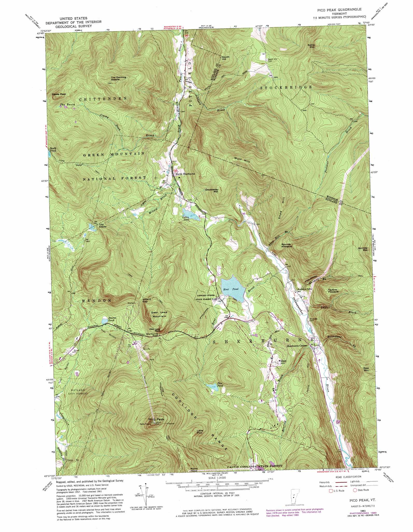
USGS Topo Quad 43072f7 - 1:24,000 scale
| Topo Map Name: | Pico Peak |
| USGS Topo Quad ID: | 43072f7 |
| Print Size: | ca. 21 1/4" wide x 27" high |
| Southeast Coordinates: | 43.625° N latitude / 72.75° W longitude |
| Map Center Coordinates: | 43.6875° N latitude / 72.8125° W longitude |
| U.S. State: | VT |
| Filename: | o43072f7.jpg |
| Download Map JPG Image: | Pico Peak topo map 1:24,000 scale |
| Map Type: | Topographic |
| Topo Series: | 7.5´ |
| Map Scale: | 1:24,000 |
| Source of Map Images: | United States Geological Survey (USGS) |
| Alternate Map Versions: |
Pico Peak VT 1961, updated 1964 Download PDF Buy paper map Pico Peak VT 1961, updated 1966 Download PDF Buy paper map Pico Peak VT 1961, updated 1973 Download PDF Buy paper map Pico Peak VT 1961, updated 1981 Download PDF Buy paper map Pico Peak VT 1961, updated 1981 Download PDF Buy paper map Pico Peak VT 1997, updated 2000 Download PDF Buy paper map Pico Peak VT 2012 Download PDF Buy paper map Pico Peak VT 2015 Download PDF Buy paper map |
| FStopo: | US Forest Service topo Pico Peak is available: Download FStopo PDF Download FStopo TIF |
1:24,000 Topo Quads surrounding Pico Peak
East Middlebury |
Bread Loaf |
Hancock |
Randolph |
Randolph Center |
Brandon |
Mount Carmel |
Rochester |
Bethel |
South Royalton |
Proctor |
Chittenden |
Pico Peak |
Delectable Mountain |
Woodstock North |
West Rutland |
Rutland |
Killington Peak |
Plymouth |
Woodstock South |
Middletown Springs |
Wallingford |
Mount Holly |
Ludlow |
Cavendish |
> Back to 43072e1 at 1:100,000 scale
> Back to 43072a1 at 1:250,000 scale
> Back to U.S. Topo Maps home
Pico Peak topo map: Gazetteer
Pico Peak: Basins
The Basin elevation 676m 2217′Pico Peak: Dams
Beaver Pond Dam elevation 564m 1850′Colton Pond Dam elevation 405m 1328′
Kent Pond Dam elevation 466m 1528′
Sherburne Corporation Site 1 Dam elevation 667m 2188′
Pico Peak: Gaps
Sherburne Pass elevation 657m 2155′The Elbow elevation 594m 1948′
Willard Gap elevation 685m 2247′
Pico Peak: Lakes
Beaver Pond elevation 564m 1850′Pico Pond elevation 658m 2158′
Pico Peak: Parks
Gifford Woods Natural Area elevation 466m 1528′Giffords Woods State Forest Park elevation 497m 1630′
Lew Newall Wildlife Management Area elevation 742m 2434′
Valley Park elevation 367m 1204′
Pico Peak: Populated Places
Killington elevation 392m 1286′Killington Village elevation 612m 2007′
North Sherburne elevation 372m 1220′
Sherburne Center elevation 379m 1243′
Telemark Village elevation 509m 1669′
The Woods elevation 532m 1745′
Pico Peak: Post Offices
Killington Post Office elevation 399m 1309′Sherburne Center Post Office elevation 371m 1217′
Pico Peak: Reservoirs
Colton Pond elevation 405m 1328′Kent Pond elevation 466m 1528′
Pico Peak: Streams
Brimstone Brook elevation 360m 1181′Jimmy Dean Brook elevation 318m 1043′
Johnson Brook elevation 304m 997′
Kent Brook elevation 365m 1197′
Middle Brook elevation 377m 1236′
Quimby Brook elevation 365m 1197′
Roaring Brook elevation 359m 1177′
Shaw Hill Brook elevation 372m 1220′
Taylor Brook elevation 364m 1194′
Pico Peak: Summits
Daves Peak elevation 819m 2687′Deer Leap Mountain elevation 847m 2778′
Deer Leap Rock elevation 770m 2526′
Doubleday Mountain elevation 627m 2057′
East Mountain elevation 847m 2778′
Little Pico elevation 948m 3110′
Pico Peak elevation 1203m 3946′
Quimby Mountain elevation 798m 2618′
Rams Head elevation 1098m 3602′
Round Pinnacle elevation 520m 1706′
Sable Mountain elevation 799m 2621′
Shaw Hill elevation 828m 2716′
South Hill elevation 668m 2191′
Taylors Pinnacle elevation 642m 2106′
The Darning Needle elevation 879m 2883′
West Hill elevation 574m 1883′
Wolf Hill elevation 772m 2532′
Pico Peak: Trails
Circle Trail elevation 730m 2395′Telefon Trail elevation 481m 1578′
Pico Peak digital topo map on disk
Buy this Pico Peak topo map showing relief, roads, GPS coordinates and other geographical features, as a high-resolution digital map file on DVD:
New York, Vermont, Connecticut & Western Massachusetts
Buy digital topo maps: New York, Vermont, Connecticut & Western Massachusetts