Chittenden Topo Map Vermont
To zoom in, hover over the map of Chittenden
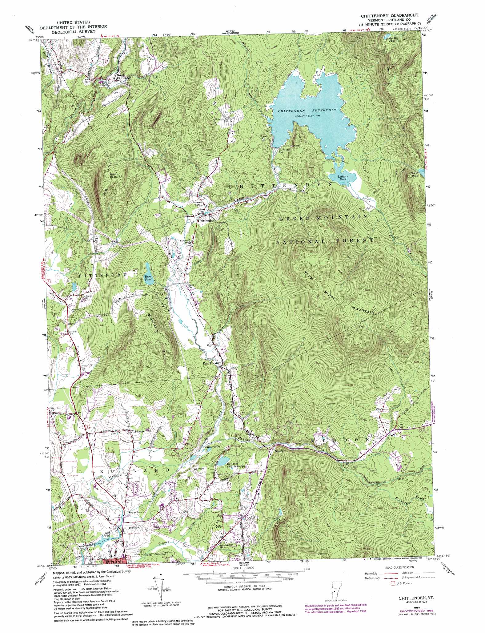
USGS Topo Quad 43072f8 - 1:24,000 scale
| Topo Map Name: | Chittenden |
| USGS Topo Quad ID: | 43072f8 |
| Print Size: | ca. 21 1/4" wide x 27" high |
| Southeast Coordinates: | 43.625° N latitude / 72.875° W longitude |
| Map Center Coordinates: | 43.6875° N latitude / 72.9375° W longitude |
| U.S. State: | VT |
| Filename: | o43072f8.jpg |
| Download Map JPG Image: | Chittenden topo map 1:24,000 scale |
| Map Type: | Topographic |
| Topo Series: | 7.5´ |
| Map Scale: | 1:24,000 |
| Source of Map Images: | United States Geological Survey (USGS) |
| Alternate Map Versions: |
Chittenden VT 1961, updated 1964 Download PDF Buy paper map Chittenden VT 1961, updated 1966 Download PDF Buy paper map Chittenden VT 1961, updated 1976 Download PDF Buy paper map Chittenden VT 1961, updated 1989 Download PDF Buy paper map Chittenden VT 1961, updated 1989 Download PDF Buy paper map Chittenden VT 1997, updated 2000 Download PDF Buy paper map Chittenden VT 2012 Download PDF Buy paper map Chittenden VT 2015 Download PDF Buy paper map |
| FStopo: | US Forest Service topo Chittenden is available: Download FStopo PDF Download FStopo TIF |
1:24,000 Topo Quads surrounding Chittenden
Cornwall |
East Middlebury |
Bread Loaf |
Hancock |
Randolph |
Sudbury |
Brandon |
Mount Carmel |
Rochester |
Bethel |
Bomoseen |
Proctor |
Chittenden |
Pico Peak |
Delectable Mountain |
Poultney |
West Rutland |
Rutland |
Killington Peak |
Plymouth |
Wells |
Middletown Springs |
Wallingford |
Mount Holly |
Ludlow |
> Back to 43072e1 at 1:100,000 scale
> Back to 43072a1 at 1:250,000 scale
> Back to U.S. Topo Maps home
Chittenden topo map: Gazetteer
Chittenden: Airports
Velco Heliport elevation 220m 721′Chittenden: Bridges
Twin Bridge (historical) elevation 207m 679′Chittenden: Dams
Chittenden Dam elevation 457m 1499′Glen Dam elevation 237m 777′
Lefferts Dam elevation 457m 1499′
Patch Dam elevation 186m 610′
Rutland City Reservoir Dam elevation 277m 908′
Chittenden: Forests
Rutland City Forest elevation 475m 1558′Rutland Municipal Forest elevation 222m 728′
Chittenden: Lakes
Burr Pond elevation 356m 1167′Lefferts Pond elevation 457m 1499′
North Pond elevation 759m 2490′
Patch Pond elevation 186m 610′
South Pond elevation 691m 2267′
Chittenden: Parks
Northwood Park elevation 270m 885′Chittenden: Populated Places
Blue Ridge Acres elevation 208m 682′Chasanna Acres elevation 225m 738′
Chittenden elevation 346m 1135′
Colonial Estates elevation 221m 725′
Countryside Estates elevation 223m 731′
East Pittsford elevation 305m 1000′
Mendon elevation 314m 1030′
Mountain View Estates elevation 206m 675′
North Chittenden elevation 305m 1000′
Pinecrest Acres elevation 262m 859′
Pinnacle Ridge elevation 214m 702′
Prospect Hill elevation 238m 780′
Sugarwood Hill elevation 261m 856′
Chittenden: Post Offices
Chittenden Post Office elevation 344m 1128′Chittenden: Reservoirs
Chittenden Reservoir elevation 457m 1499′Rutland City Reservoir elevation 277m 908′
Chittenden: Streams
Billings Brook elevation 456m 1496′Brewers Brook elevation 424m 1391′
Green Brook elevation 456m 1496′
Hewitt Brook elevation 456m 1496′
Mendon Brook elevation 246m 807′
Chittenden: Summits
Bald Peak elevation 532m 1745′Blue Ridge Mountain elevation 991m 3251′
Blueberry Hill elevation 501m 1643′
Long Hill elevation 532m 1745′
Chittenden: Trails
Canty Trail elevation 798m 2618′South Pond Trail elevation 542m 1778′
Chittenden digital topo map on disk
Buy this Chittenden topo map showing relief, roads, GPS coordinates and other geographical features, as a high-resolution digital map file on DVD:
New York, Vermont, Connecticut & Western Massachusetts
Buy digital topo maps: New York, Vermont, Connecticut & Western Massachusetts