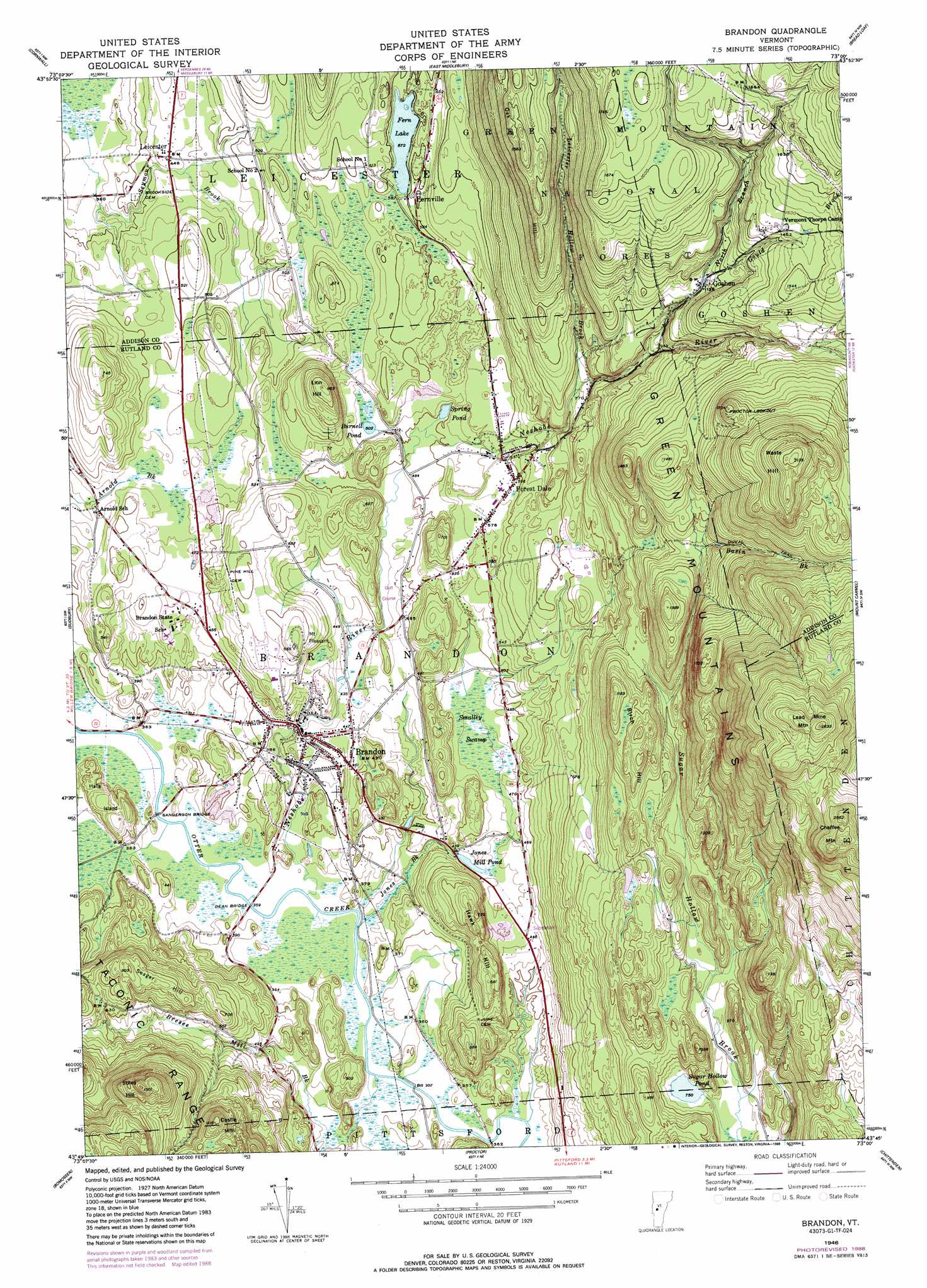
Brandon Topo Map Vermont
To zoom in, hover over the map of Brandon
USGS Topo Quad 43073g1 - 1:24,000 scale
| Topo Map Name: | Brandon |
| USGS Topo Quad ID: | 43073g1 |
| Print Size: | ca. 21 1/4" wide x 27" high |
| Southeast Coordinates: | 43.75° N latitude / 73° W longitude |
| Map Center Coordinates: | 43.8125° N latitude / 73.0625° W longitude |
| U.S. State: | VT |
| Filename: | o43073g1.jpg |
| Download Map JPG Image: | Brandon topo map 1:24,000 scale |
| Map Type: | Topographic |
| Topo Series: | 7.5´ |
| Map Scale: | 1:24,000 |
| Source of Map Images: | United States Geological Survey (USGS) |
| Alternate Map Versions: |
Brandon VT 1946, updated 1958 Download PDF Buy paper map Brandon VT 1946, updated 1965 Download PDF Buy paper map Brandon VT 1946, updated 1969 Download PDF Buy paper map Brandon VT 1946, updated 1988 Download PDF Buy paper map Brandon VT 1997, updated 2000 Download PDF Buy paper map Brandon VT 2012 Download PDF Buy paper map Brandon VT 2015 Download PDF Buy paper map |
| FStopo: | US Forest Service topo Brandon is available: Download FStopo PDF Download FStopo TIF |
1:24,000 Topo Quads surrounding Brandon
Snake Mountain |
Middlebury |
South Mountain |
Lincoln |
Warren |
Bridport |
Cornwall |
East Middlebury |
Bread Loaf |
Hancock |
Orwell |
Sudbury |
Brandon |
Mount Carmel |
Rochester |
Benson |
Bomoseen |
Proctor |
Chittenden |
Pico Peak |
Thorn Hill |
Poultney |
West Rutland |
Rutland |
Killington Peak |
> Back to 43073e1 at 1:100,000 scale
> Back to 43072a1 at 1:250,000 scale
> Back to U.S. Topo Maps home
Brandon topo map: Gazetteer
Brandon: Bridges
Dean Bridge elevation 107m 351′Sanderson Bridge elevation 110m 360′
Brandon: Forests
Brandon Municipal Forest elevation 651m 2135′Goshen Municipal Forest elevation 611m 2004′
Brandon: Islands
Halls Island elevation 143m 469′Brandon: Lakes
Burnell Pond elevation 153m 501′Fern Lake elevation 174m 570′
Jones Mill Pond elevation 131m 429′
Spring Pond elevation 151m 495′
Sugar Hollow Pond elevation 228m 748′
Brandon: Parks
Bradbury State Park elevation 171m 561′Brandon Village Historic District elevation 126m 413′
Brandon: Populated Places
Brandon elevation 130m 426′Fernville elevation 183m 600′
Forest Dale elevation 181m 593′
Goshen elevation 345m 1131′
Leicester elevation 135m 442′
Mount Pleasant elevation 201m 659′
Sugar Hollow elevation 227m 744′
Towtaid (historical) elevation 135m 442′
Brandon: Post Offices
Brandon Post Office elevation 118m 387′Brandon: Streams
Basin Brook elevation 342m 1122′Bresee Mill Brook elevation 108m 354′
Gould Brook elevation 347m 1138′
Jones Brook elevation 108m 354′
Leicester Hollow Brook elevation 223m 731′
Neshobe River elevation 106m 347′
North Branch Neshobe River elevation 283m 928′
Brandon: Summits
Birch Hill elevation 369m 1210′Castle Hill elevation 338m 1108′
Chaffee Mountain elevation 780m 2559′
Hawk Hill elevation 208m 682′
Lead Mine Mountain elevation 799m 2621′
Lion Hill elevation 258m 846′
Oak Hill elevation 470m 1541′
Seager Hill elevation 242m 793′
Stiles Hill elevation 397m 1302′
Waste Hill elevation 648m 2125′
Brandon: Swamps
Smalley Swamp elevation 139m 456′Brandon: Trails
Chandler Ridge Trail elevation 444m 1456′Duval Trail elevation 411m 1348′
Leicester Hollow Trail elevation 361m 1184′
Brandon digital topo map on disk
Buy this Brandon topo map showing relief, roads, GPS coordinates and other geographical features, as a high-resolution digital map file on DVD:
New York, Vermont, Connecticut & Western Massachusetts
Buy digital topo maps: New York, Vermont, Connecticut & Western Massachusetts