Cambridge Topo Map New York
To zoom in, hover over the map of Cambridge
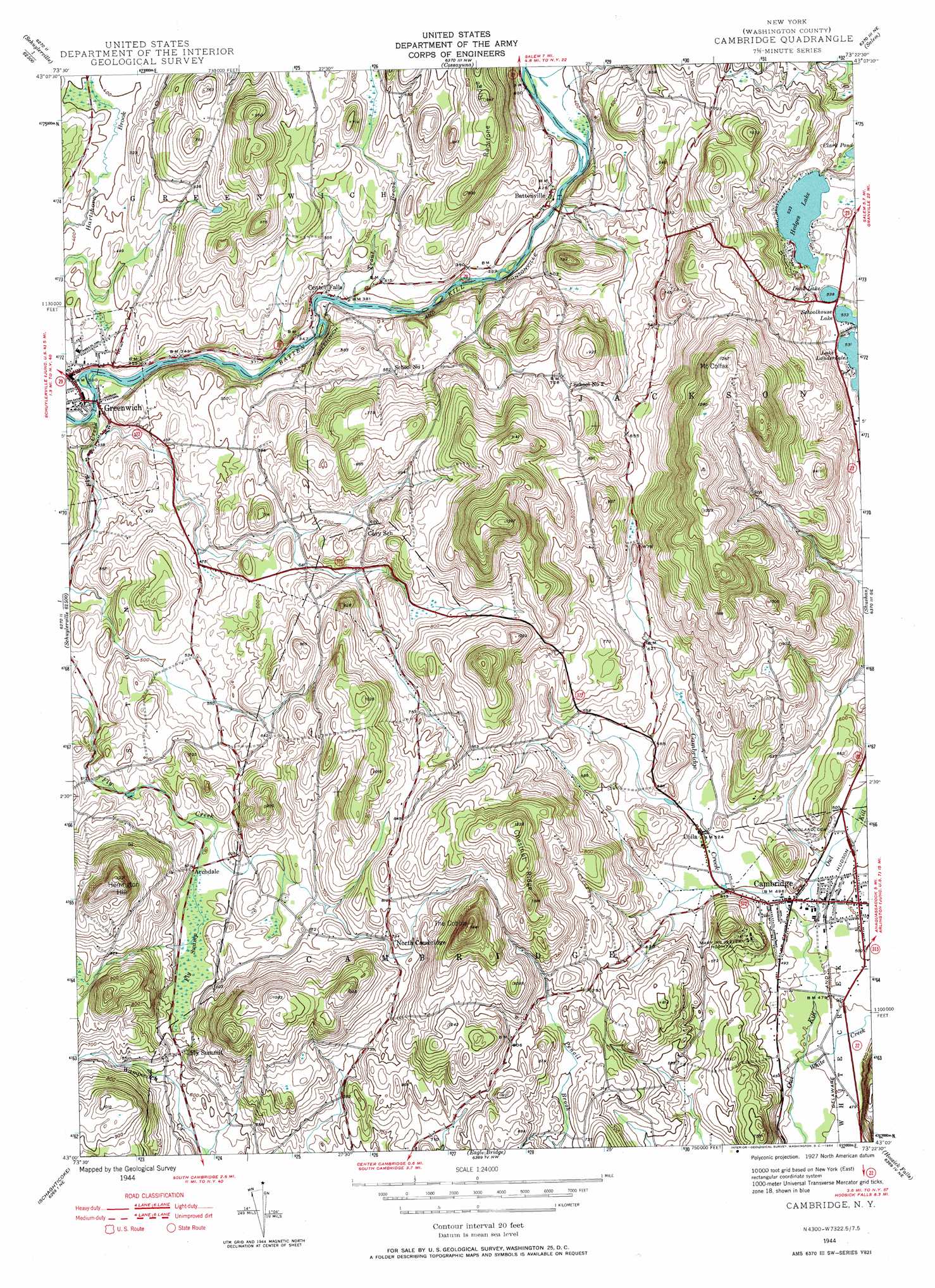
USGS Topo Quad 43073a4 - 1:24,000 scale
| Topo Map Name: | Cambridge |
| USGS Topo Quad ID: | 43073a4 |
| Print Size: | ca. 21 1/4" wide x 27" high |
| Southeast Coordinates: | 43° N latitude / 73.375° W longitude |
| Map Center Coordinates: | 43.0625° N latitude / 73.4375° W longitude |
| U.S. State: | NY |
| Filename: | o43073a4.jpg |
| Download Map JPG Image: | Cambridge topo map 1:24,000 scale |
| Map Type: | Topographic |
| Topo Series: | 7.5´ |
| Map Scale: | 1:24,000 |
| Source of Map Images: | United States Geological Survey (USGS) |
| Alternate Map Versions: |
Cambridge NY 1944, updated 1955 Download PDF Buy paper map Cambridge NY 1944, updated 1964 Download PDF Buy paper map Cambridge NY 1944, updated 1964 Download PDF Buy paper map Cambridge NY 2010 Download PDF Buy paper map Cambridge NY 2013 Download PDF Buy paper map Cambridge NY 2016 Download PDF Buy paper map |
1:24,000 Topo Quads surrounding Cambridge
Glens Falls |
Hudson Falls |
Hartford |
West Pawlet |
Pawlet |
Gansevoort |
Fort Miller |
Cossayuna |
Salem |
West Rupert |
Quaker Springs |
Schuylerville |
Cambridge |
Shushan |
Arlington |
Mechanicville |
Schaghticoke |
Eagle Bridge |
Hoosick Falls |
Bennington |
Troy North |
Tomhannock |
Grafton |
North Pownal |
Pownal |
> Back to 43073a1 at 1:100,000 scale
> Back to 43072a1 at 1:250,000 scale
> Back to U.S. Topo Maps home
Cambridge topo map: Gazetteer
Cambridge: Lakes
Dead Lake elevation 164m 538′Hedges Lake elevation 162m 531′
Schoolhouse Lake elevation 162m 531′
Cambridge: Parks
Cambridge Historic District elevation 149m 488′Village of Greenwich Historic District elevation 115m 377′
Cambridge: Populated Places
Archdale elevation 175m 574′Battenville elevation 128m 419′
Cambridge elevation 149m 488′
Center Falls elevation 112m 367′
Coila elevation 161m 528′
Fly Summit elevation 185m 606′
Greenwich elevation 114m 374′
North Cambridge elevation 243m 797′
Cambridge: Ridges
Chestnut Ridge elevation 372m 1220′Redstone Ridge elevation 257m 843′
Cambridge: Streams
Cambridge Creek elevation 146m 479′Fly Creek elevation 100m 328′
Trout Brook elevation 111m 364′
Cambridge: Summits
Herrington Hill elevation 369m 1210′Mount Colfax elevation 386m 1266′
The Cobble elevation 443m 1453′
Cambridge: Swamps
Fly Swamp elevation 175m 574′Cambridge digital topo map on disk
Buy this Cambridge topo map showing relief, roads, GPS coordinates and other geographical features, as a high-resolution digital map file on DVD:
New York, Vermont, Connecticut & Western Massachusetts
Buy digital topo maps: New York, Vermont, Connecticut & Western Massachusetts