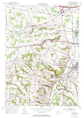
Clinton Topo Map New York
To zoom in, hover over the map of Clinton
USGS Topo Quad 43075a4 - 1:24,000 scale
| Topo Map Name: | Clinton |
| USGS Topo Quad ID: | 43075a4 |
| Print Size: | ca. 21 1/4" wide x 27" high |
| Southeast Coordinates: | 43° N latitude / 75.375° W longitude |
| Map Center Coordinates: | 43.0625° N latitude / 75.4375° W longitude |
| U.S. State: | NY |
| Filename: | o43075a4.jpg |
| Download Map JPG Image: | Clinton topo map 1:24,000 scale |
| Map Type: | Topographic |
| Topo Series: | 7.5´ |
| Map Scale: | 1:24,000 |
| Source of Map Images: | United States Geological Survey (USGS) |
| Alternate Map Versions: |
Clinton NY 1949 Download PDF Buy paper map Clinton NY 1955, updated 1957 Download PDF Buy paper map Clinton NY 1955, updated 1966 Download PDF Buy paper map Clinton NY 2010 Download PDF Buy paper map Clinton NY 2013 Download PDF Buy paper map Clinton NY 2016 Download PDF Buy paper map |
1:24,000 Topo Quads surrounding Clinton
> Back to 43075a1 at 1:100,000 scale
> Back to 43074a1 at 1:250,000 scale
> Back to U.S. Topo Maps home
Clinton topo map: Gazetteer
Clinton: Crossings
Interchange Number 32 elevation 179m 587′Clinton: Parks
Campus Road Athletic Field elevation 264m 866′Ferguson Intramural Fields elevation 278m 912′
Gray Tennis Courts elevation 269m 882′
Love Field elevation 277m 908′
Mason Field elevation 282m 925′
Royce Baseball Field elevation 271m 889′
Steuben Field elevation 273m 895′
William M Bristol Junior Swimming Pool elevation 272m 892′
Clinton: Populated Places
Clark Mills elevation 157m 515′Clinton elevation 184m 603′
Farmers Mills elevation 197m 646′
Franklin Springs elevation 192m 629′
Hecla elevation 181m 593′
Kirkland elevation 161m 528′
Lairdsville elevation 220m 721′
Wells Corner elevation 297m 974′
Westmoreland elevation 159m 521′
Clinton: Reservoirs
Clinton Reservoir elevation 251m 823′Hamilton College Reservoirs elevation 330m 1082′
Clinton: Streams
Turkey Creek elevation 201m 659′White Creek elevation 183m 600′
Clinton: Summits
Christmas Knob elevation 181m 593′College Hill elevation 273m 895′
Gibson Hill elevation 317m 1040′
Prospect Hill elevation 419m 1374′
Sunset Hill elevation 197m 646′
Clinton: Valleys
Kirkland Glen elevation 189m 620′Clinton digital topo map on disk
Buy this Clinton topo map showing relief, roads, GPS coordinates and other geographical features, as a high-resolution digital map file on DVD:
New York, Vermont, Connecticut & Western Massachusetts
Buy digital topo maps: New York, Vermont, Connecticut & Western Massachusetts


