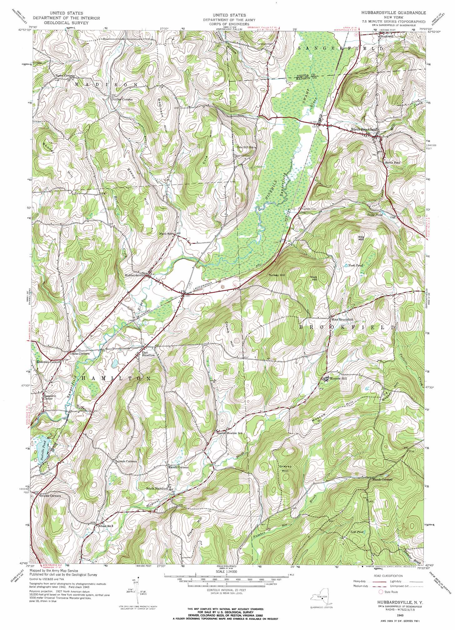
Hubbardsville Topo Map New York
To zoom in, hover over the map of Hubbardsville
USGS Topo Quad 42075g4 - 1:24,000 scale
| Topo Map Name: | Hubbardsville |
| USGS Topo Quad ID: | 42075g4 |
| Print Size: | ca. 21 1/4" wide x 27" high |
| Southeast Coordinates: | 42.75° N latitude / 75.375° W longitude |
| Map Center Coordinates: | 42.8125° N latitude / 75.4375° W longitude |
| U.S. State: | NY |
| Filename: | o42075g4.jpg |
| Download Map JPG Image: | Hubbardsville topo map 1:24,000 scale |
| Map Type: | Topographic |
| Topo Series: | 7.5´ |
| Map Scale: | 1:24,000 |
| Source of Map Images: | United States Geological Survey (USGS) |
| Alternate Map Versions: |
Hubbardsville NY 1943, updated 1960 Download PDF Buy paper map Hubbardsville NY 1943, updated 1974 Download PDF Buy paper map Hubbardsville NY 2010 Download PDF Buy paper map Hubbardsville NY 2013 Download PDF Buy paper map Hubbardsville NY 2016 Download PDF Buy paper map |
1:24,000 Topo Quads surrounding Hubbardsville
Oneida |
Vernon |
Clinton |
Utica West |
Utica East |
Morrisville |
Munnsville |
Oriskany Falls |
Cassville |
West Winfield |
West Eaton |
Hamilton |
Hubbardsville |
Brookfield |
Unadilla Forks |
Otselic |
Earlville |
Sherburne |
New Berlin North |
Edmeston |
East Pharsalia |
Norwich |
Holmesville |
New Berlin South |
Morris |
> Back to 42075e1 at 1:100,000 scale
> Back to 42074a1 at 1:250,000 scale
> Back to U.S. Topo Maps home
Hubbardsville topo map: Gazetteer
Hubbardsville: Lakes
Barns Pond elevation 432m 1417′Lost Pond elevation 524m 1719′
Poolville Pond elevation 334m 1095′
Snow Pond elevation 429m 1407′
York Pond elevation 528m 1732′
Hubbardsville: Populated Places
Brooks Corner elevation 382m 1253′East Hamilton elevation 374m 1227′
Hamilton Center elevation 374m 1227′
Hubbardsville elevation 370m 1213′
Moscow Hill elevation 443m 1453′
North Brookfield elevation 396m 1299′
Sigby Corners elevation 456m 1496′
South Hamilton elevation 410m 1345′
Stockwell elevation 386m 1266′
West Brookfield elevation 489m 1604′
Hubbardsville: Streams
Hunt Creek elevation 353m 1158′Mill Creek elevation 363m 1190′
Hubbardsville: Summits
Bacon Hill elevation 500m 1640′Bonney Hill elevation 538m 1765′
Clark Hill elevation 538m 1765′
Cole Hill elevation 509m 1669′
Crumb Hill elevation 558m 1830′
Grassy Hill elevation 555m 1820′
Moscow Hill elevation 536m 1758′
Quaker Hill elevation 568m 1863′
Ritz Hill elevation 576m 1889′
Robinson Hill elevation 555m 1820′
Turkey Hill elevation 557m 1827′
York Hill elevation 563m 1847′
Hubbardsville: Swamps
Ninemile Swamp elevation 362m 1187′Hubbardsville: Valleys
Tinker Hollow elevation 371m 1217′Hubbardsville digital topo map on disk
Buy this Hubbardsville topo map showing relief, roads, GPS coordinates and other geographical features, as a high-resolution digital map file on DVD:
New York, Vermont, Connecticut & Western Massachusetts
Buy digital topo maps: New York, Vermont, Connecticut & Western Massachusetts