Fortin Draw Topo Map Wyoming
To zoom in, hover over the map of Fortin Draw
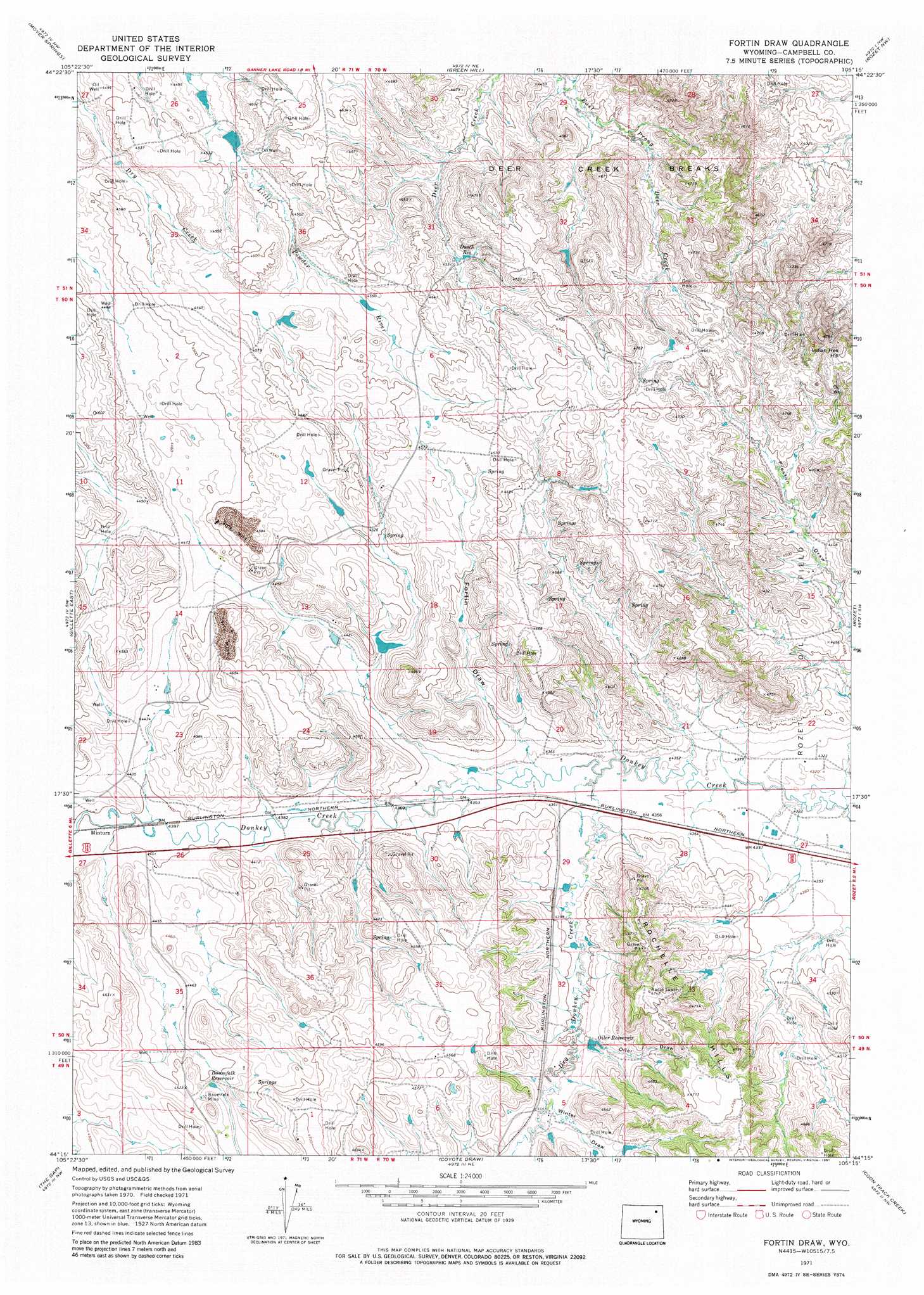
USGS Topo Quad 44105c3 - 1:24,000 scale
| Topo Map Name: | Fortin Draw |
| USGS Topo Quad ID: | 44105c3 |
| Print Size: | ca. 21 1/4" wide x 27" high |
| Southeast Coordinates: | 44.25° N latitude / 105.25° W longitude |
| Map Center Coordinates: | 44.3125° N latitude / 105.3125° W longitude |
| U.S. State: | WY |
| Filename: | o44105c3.jpg |
| Download Map JPG Image: | Fortin Draw topo map 1:24,000 scale |
| Map Type: | Topographic |
| Topo Series: | 7.5´ |
| Map Scale: | 1:24,000 |
| Source of Map Images: | United States Geological Survey (USGS) |
| Alternate Map Versions: |
Fortin Draw WY 1971, updated 1975 Download PDF Buy paper map Fortin Draw WY 1971, updated 1981 Download PDF Buy paper map Fortin Draw WY 2012 Download PDF Buy paper map Fortin Draw WY 2015 Download PDF Buy paper map |
1:24,000 Topo Quads surrounding Fortin Draw
Calf Creek |
Weston Sw |
Lone Tree Creek |
Adon |
Flag Butte |
Rawhide School |
Moyer Springs |
Green Hill |
Rozet Nw |
Rozet Ne |
Gillette West |
Gillette East |
Fortin Draw |
Rozet |
Rozet Se |
Appel Butte |
The Gap |
Coyote Draw |
Coon Track Creek |
Whitetail Creek Ne |
Scaper Reservoir |
The Gap Sw |
Saddle Horse Butte |
Whitetail Creek |
Whitetail Creek Se |
> Back to 44105a1 at 1:100,000 scale
> Back to 44104a1 at 1:250,000 scale
> Back to U.S. Topo Maps home
Fortin Draw topo map: Gazetteer
Fortin Draw: Airports
Madsen Airport elevation 1383m 4537′Fortin Draw: Dams
Tanner Number 1 Dam elevation 1397m 4583′Fortin Draw: Mines
Baumfalk Mine elevation 1376m 4514′Ditto Mine elevation 1375m 4511′
Fortin Draw: Ranges
Deer Creek Breaks elevation 1353m 4438′Fortin Draw: Reservoirs
Baumfalk Reservoir elevation 1377m 4517′Dutch Reservoir elevation 1378m 4520′
Oiler Reservoir elevation 1348m 4422′
Tanner Number 1 Reservoir elevation 1397m 4583′
Fortin Draw: Streams
Dry Donkey Creek elevation 1323m 4340′Fortin Draw: Summits
Rochelle Hills elevation 1437m 4714′Fortin Draw: Valleys
Fortin Draw elevation 1335m 4379′Oiler Draw elevation 1348m 4422′
Winter Draw elevation 1348m 4422′
Fortin Draw digital topo map on disk
Buy this Fortin Draw topo map showing relief, roads, GPS coordinates and other geographical features, as a high-resolution digital map file on DVD:
Eastern Wyoming & Western South Dakota
Buy digital topo maps: Eastern Wyoming & Western South Dakota