Digger Mountain Topo Map Oregon
To zoom in, hover over the map of Digger Mountain
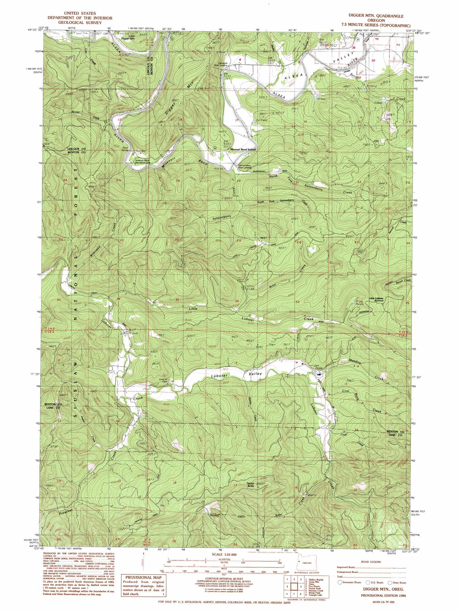
USGS Topo Quad 44123c6 - 1:24,000 scale
| Topo Map Name: | Digger Mountain |
| USGS Topo Quad ID: | 44123c6 |
| Print Size: | ca. 21 1/4" wide x 27" high |
| Southeast Coordinates: | 44.25° N latitude / 123.625° W longitude |
| Map Center Coordinates: | 44.3125° N latitude / 123.6875° W longitude |
| U.S. State: | OR |
| Filename: | o44123c6.jpg |
| Download Map JPG Image: | Digger Mountain topo map 1:24,000 scale |
| Map Type: | Topographic |
| Topo Series: | 7.5´ |
| Map Scale: | 1:24,000 |
| Source of Map Images: | United States Geological Survey (USGS) |
| Alternate Map Versions: |
Digger Mtn OR 1984, updated 1984 Download PDF Buy paper map Digger Mountain OR 2011 Download PDF Buy paper map Digger Mountain OR 2014 Download PDF Buy paper map |
| FStopo: | US Forest Service topo Digger Mountain is available: Download FStopo PDF Download FStopo TIF |
1:24,000 Topo Quads surrounding Digger Mountain
Toledo South |
Elk City |
Harlan |
Marys Peak |
Wren |
Tidewater |
Hellion Rapids |
Grass Mountain |
Alsea |
Flat Mountain |
Cannibal Mountain |
Five Rivers |
Digger Mountain |
Prairie Peak |
Glenbrook |
Cummins Peak |
Herman Creek |
Windy Peak |
Triangle Lake |
Horton |
Tiernan |
Mapleton |
Greenleaf |
Walton |
Noti |
> Back to 44123a1 at 1:100,000 scale
> Back to 44122a1 at 1:250,000 scale
> Back to U.S. Topo Maps home
Digger Mountain topo map: Gazetteer
Digger Mountain: Bends
Missouri Bend elevation 67m 219′Digger Mountain: Gaps
Little Lobster Summit elevation 288m 944′Digger Mountain: Parks
Campbell County Park elevation 67m 219′Missouri Bend Recreation Site elevation 98m 321′
Salmonberry County Park & Campground elevation 64m 209′
Digger Mountain: Post Offices
Box Post Office (historical) elevation 77m 252′Lobster Post Office (historical) elevation 117m 383′
Digger Mountain: Springs
Scoville Spring elevation 120m 393′Digger Mountain: Streams
Bear Creek elevation 146m 479′Benner Creek elevation 55m 180′
Bovine Creek elevation 44m 144′
Briar Creek elevation 92m 301′
Burch Creek elevation 75m 246′
Coal Bank Creek elevation 104m 341′
Cook Creek elevation 112m 367′
Jasper Creek elevation 85m 278′
Little Lobster Creek elevation 72m 236′
Maltby Creek elevation 73m 239′
Martha Creek elevation 87m 285′
Meadow Creek elevation 103m 337′
Narrow Creek elevation 138m 452′
North Fork Salmonberry Creek elevation 71m 232′
Preacher Creek elevation 72m 236′
Salmonberry Creek elevation 66m 216′
Schoolhouse Creek elevation 74m 242′
South Fork Salmonberry Creek elevation 81m 265′
Wilkinson Creek elevation 62m 203′
Digger Mountain: Summits
Digger Mountain elevation 372m 1220′Taylor Butte elevation 655m 2148′
Digger Mountain: Valleys
Alsea Valley elevation 128m 419′Lobster Valley elevation 64m 209′
Digger Mountain digital topo map on disk
Buy this Digger Mountain topo map showing relief, roads, GPS coordinates and other geographical features, as a high-resolution digital map file on DVD: