Tumbledown Mountain Topo Map Maine
To zoom in, hover over the map of Tumbledown Mountain
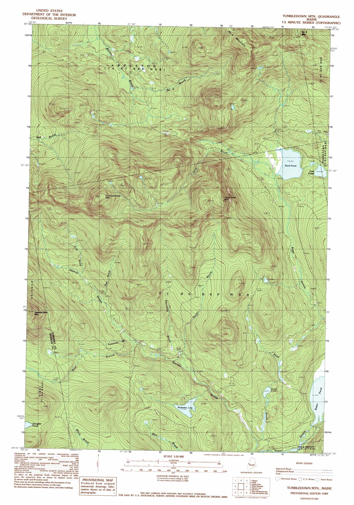
USGS Topo Quad 45070d4 - 1:24,000 scale
| Topo Map Name: | Tumbledown Mountain |
| USGS Topo Quad ID: | 45070d4 |
| Print Size: | ca. 21 1/4" wide x 27" high |
| Southeast Coordinates: | 45.375° N latitude / 70.375° W longitude |
| Map Center Coordinates: | 45.4375° N latitude / 70.4375° W longitude |
| U.S. State: | ME |
| Filename: | o45070d4.jpg |
| Download Map JPG Image: | Tumbledown Mountain topo map 1:24,000 scale |
| Map Type: | Topographic |
| Topo Series: | 7.5´ |
| Map Scale: | 1:24,000 |
| Source of Map Images: | United States Geological Survey (USGS) |
| Alternate Map Versions: |
Tumbledown Mountain ME 1977, updated 1983 Download PDF Buy paper map Tumbledown Mtn ME 1989, updated 1989 Download PDF Buy paper map Tumbledown Mountain ME 2011 Download PDF Buy paper map Tumbledown Mountain ME 2014 Download PDF Buy paper map |
1:24,000 Topo Quads surrounding Tumbledown Mountain
Skinner Ne |
Stony Brook |
Jackman |
Heald Pond |
|
Boundary Pond |
Skinner |
Holeb |
Attean Pond |
Catheart Mountain |
Merrill Mountain |
Kibby Mountain |
Tumbledown Mountain |
Spencer Lake |
Enchanted Pond |
Chain Of Ponds |
Jim Pond |
King And Bartlett Mountain |
King And Bartlett Lake |
Basin Mountain |
Black Mountain |
Tim Mountain |
Stratton |
The Horns |
Little Bigelow Mountain |
> Back to 45070a1 at 1:100,000 scale
> Back to 45070a1 at 1:250,000 scale
> Back to U.S. Topo Maps home
Tumbledown Mountain topo map: Gazetteer
Tumbledown Mountain: Lakes
Blakeslee Lake elevation 529m 1735′Davis Pond elevation 464m 1522′
Iron Pond elevation 510m 1673′
Rock Pond elevation 497m 1630′
Tumbledown Mountain: Streams
Baker Stream elevation 431m 1414′Cold Brook elevation 560m 1837′
Davis Brook elevation 444m 1456′
Dud Brook elevation 516m 1692′
Durgin Brook elevation 489m 1604′
Gold Brook elevation 498m 1633′
Number Six Brook elevation 486m 1594′
Spaulding Brook elevation 484m 1587′
Sweetster Brook elevation 520m 1706′
West Branch Spencer Stream elevation 518m 1699′
Tumbledown Mountain: Summits
Greenlaw Mountain elevation 888m 2913′Number Six Mountain elevation 1007m 3303′
Spencer Bale Mountain elevation 996m 3267′
Three Slide Mountain elevation 891m 2923′
Tumbledown Mountain elevation 1091m 3579′
Tumbledown Mountain digital topo map on disk
Buy this Tumbledown Mountain topo map showing relief, roads, GPS coordinates and other geographical features, as a high-resolution digital map file on DVD:
Maine, New Hampshire, Rhode Island & Eastern Massachusetts
Buy digital topo maps: Maine, New Hampshire, Rhode Island & Eastern Massachusetts