Clubfoot Creek Topo Map Montana
To zoom in, hover over the map of Clubfoot Creek
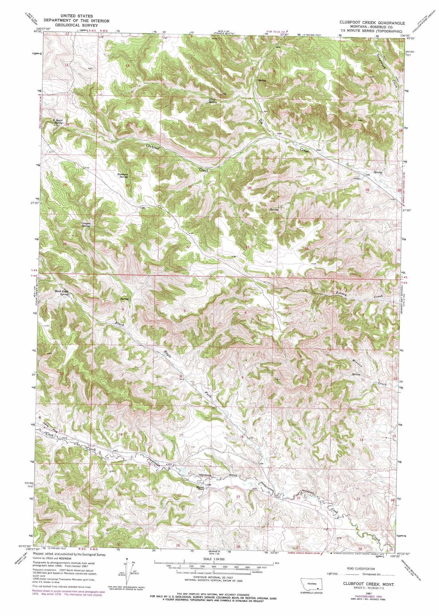
USGS Topo Quad 45106d5 - 1:24,000 scale
| Topo Map Name: | Clubfoot Creek |
| USGS Topo Quad ID: | 45106d5 |
| Print Size: | ca. 21 1/4" wide x 27" high |
| Southeast Coordinates: | 45.375° N latitude / 106.5° W longitude |
| Map Center Coordinates: | 45.4375° N latitude / 106.5625° W longitude |
| U.S. State: | MT |
| Filename: | o45106d5.jpg |
| Download Map JPG Image: | Clubfoot Creek topo map 1:24,000 scale |
| Map Type: | Topographic |
| Topo Series: | 7.5´ |
| Map Scale: | 1:24,000 |
| Source of Map Images: | United States Geological Survey (USGS) |
| Alternate Map Versions: |
Clubfoot Creek MT 1967, updated 1970 Download PDF Buy paper map Clubfoot Creek MT 1967, updated 1978 Download PDF Buy paper map Clubfoot Creek MT 2011 Download PDF Buy paper map Clubfoot Creek MT 2014 Download PDF Buy paper map |
1:24,000 Topo Quads surrounding Clubfoot Creek
Black Spring |
Jimtown |
Badger Peak |
Garfield Peak |
Ashland Ne |
Painted Hill |
Lame Deer |
Fisher Butte |
Hollowwood Creek |
Ashland |
Bull Creek Lookout |
Cook Creek Butte |
Clubfoot Creek |
Birney Day School |
Green Creek |
Taintor Desert |
Birney Sw |
Birney |
Browns Mountain |
Poker Jim Butte |
Tongue River Dam |
Spring Gulch |
Lacey Gulch |
Stroud Creek |
Hamilton Draw |
> Back to 45106a1 at 1:100,000 scale
> Back to 45106a1 at 1:250,000 scale
> Back to U.S. Topo Maps home
Clubfoot Creek topo map: Gazetteer
Clubfoot Creek: Dams
Cheyenne Number 4 Dam elevation 1009m 3310′Clubfoot Creek: Springs
05S41E01ABCA01 Spring elevation 1128m 3700′05S42E21ABDC01 Spring elevation 987m 3238′
05S42E21DBAB01 Spring elevation 997m 3270′
B Heart Spring elevation 1234m 4048′
Black Eagle Spring elevation 1140m 3740′
Canyon Spring elevation 1190m 3904′
Elliot Spring elevation 1140m 3740′
Rondeau Spring elevation 1248m 4094′
Clubfoot Creek: Streams
Black Eagle Fork elevation 976m 3202′Clubfoot Creek elevation 1075m 3526′
Saint Johns Fork elevation 1044m 3425′
Clubfoot Creek: Wells
04S42E26BDA_01 Well elevation 1031m 3382′05S41E13BCDA01 Well elevation 1050m 3444′
05S42E02AADD01 Well elevation 1023m 3356′
05S42E14ADDC01 Well elevation 980m 3215′
05S42E16DDBD01 Well elevation 994m 3261′
05S42E17CDCC01 Well elevation 1014m 3326′
05S42E18DCDB01 Well elevation 1024m 3359′
05S42E19BABD01 Well elevation 1043m 3421′
05S42E20ADAC01 Well elevation 1005m 3297′
05S42E20ADDB01 Well elevation 1005m 3297′
05S42E22BCBD01 Well elevation 987m 3238′
05S42E22DBBC01 Well elevation 979m 3211′
Clubfoot Creek digital topo map on disk
Buy this Clubfoot Creek topo map showing relief, roads, GPS coordinates and other geographical features, as a high-resolution digital map file on DVD:
Eastern Montana & Western North Dakota
Buy digital topo maps: Eastern Montana & Western North Dakota