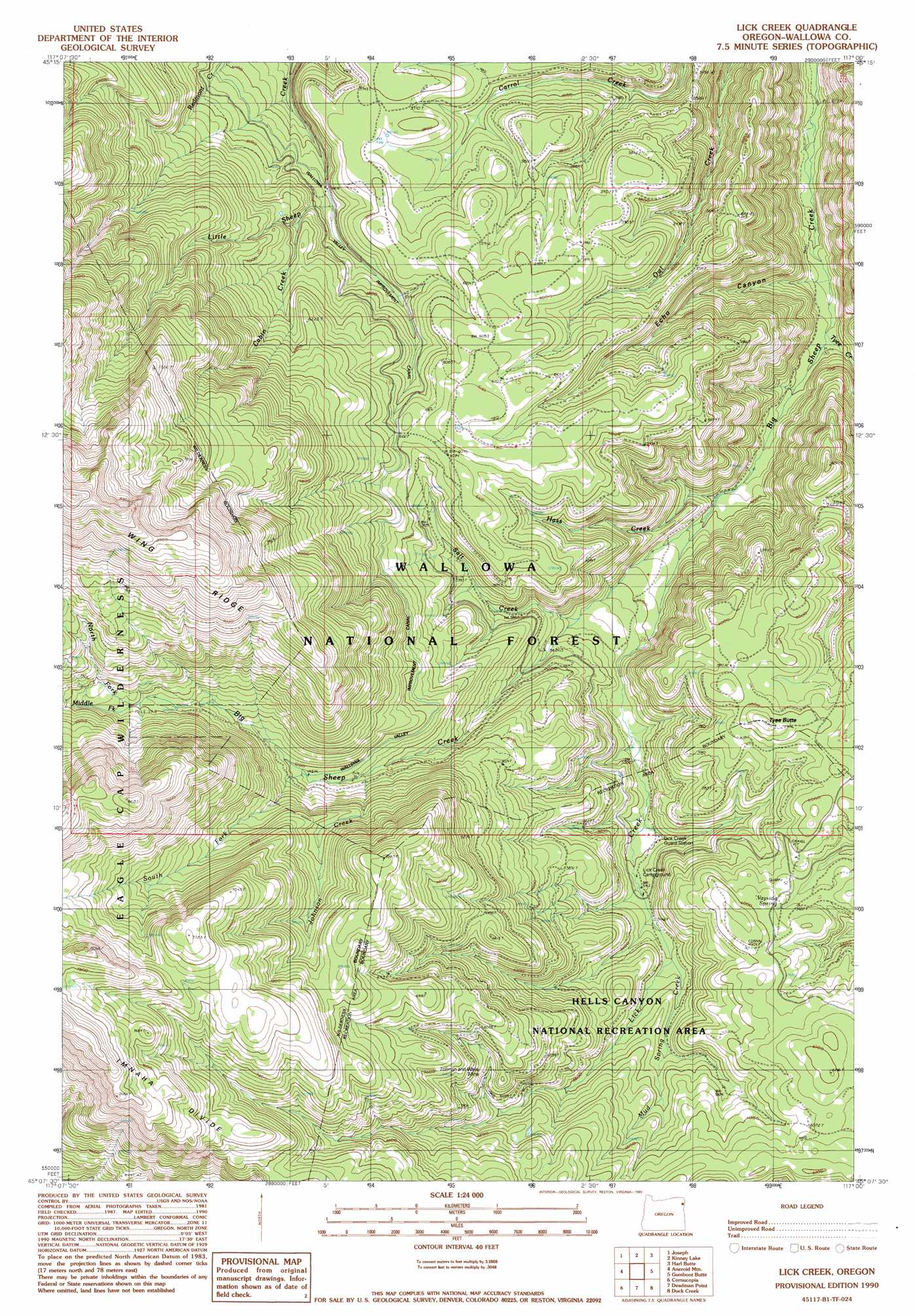
Lick Creek Topo Map Oregon
To zoom in, hover over the map of Lick Creek
USGS Topo Quad 45117b1 - 1:24,000 scale
| Topo Map Name: | Lick Creek |
| USGS Topo Quad ID: | 45117b1 |
| Print Size: | ca. 21 1/4" wide x 27" high |
| Southeast Coordinates: | 45.125° N latitude / 117° W longitude |
| Map Center Coordinates: | 45.1875° N latitude / 117.0625° W longitude |
| U.S. State: | OR |
| Filename: | o45117b1.jpg |
| Download Map JPG Image: | Lick Creek topo map 1:24,000 scale |
| Map Type: | Topographic |
| Topo Series: | 7.5´ |
| Map Scale: | 1:24,000 |
| Source of Map Images: | United States Geological Survey (USGS) |
| Alternate Map Versions: |
Lick Creek OR 1990, updated 1990 Download PDF Buy paper map Lick Creek OR 1990, updated 1990 Download PDF Buy paper map Lick Creek OR 2011 Download PDF Buy paper map Lick Creek OR 2014 Download PDF Buy paper map |
| FStopo: | US Forest Service topo Lick Creek is available: Download FStopo PDF Download FStopo TIF |
1:24,000 Topo Quads surrounding Lick Creek
Enterprise |
Joseph Nw |
Three Lakes Country |
Clear Lake Ridge |
Sheep Creek Divide |
Chief Joseph Mountain |
Joseph |
Kinney Lake |
Harl Butte |
Jaynes Ridge |
Eagle Cap |
Aneroid Mountain |
Lick Creek |
Gumboot Butte |
Puderbaugh Ridge |
Krag Peak |
Cornucopia |
Deadman Point |
Duck Creek |
Homestead |
Sparta Butte |
Jimtown |
Halfway |
Mclain Gulch |
Oxbow |
> Back to 45117a1 at 1:100,000 scale
> Back to 45116a1 at 1:250,000 scale
> Back to U.S. Topo Maps home
Lick Creek topo map: Gazetteer
Lick Creek: Lakes
Lost Lake elevation 1959m 6427′Lick Creek: Mines
Copper Mountain Mine elevation 1909m 6263′Zellman and Wells Mine elevation 1917m 6289′
Lick Creek: Parks
Wayside Springs Forest Camp elevation 1794m 5885′Lick Creek: Ridges
Blue Jay Ridge elevation 1792m 5879′Imnaha Divide elevation 2287m 7503′
Lick Creek: Springs
Target Spring elevation 1758m 5767′Wayside Spring elevation 1815m 5954′
Lick Creek: Streams
Cabin Creek elevation 1761m 5777′Hass Creek elevation 1514m 4967′
Johnson Creek elevation 1846m 6056′
Lick Creek elevation 1525m 5003′
Middle Fork Big Sheep Creek elevation 2034m 6673′
Mud Spring Creek elevation 1687m 5534′
North Fork Big Sheep Creek elevation 2034m 6673′
Salt Creek elevation 1623m 5324′
South Fork Big Sheep Creek elevation 1873m 6145′
Tyee Creek elevation 1441m 4727′
Lick Creek: Summits
Tyee Butte elevation 1860m 6102′Lick Creek: Valleys
Echo Canyon elevation 1424m 4671′Lick Creek digital topo map on disk
Buy this Lick Creek topo map showing relief, roads, GPS coordinates and other geographical features, as a high-resolution digital map file on DVD: