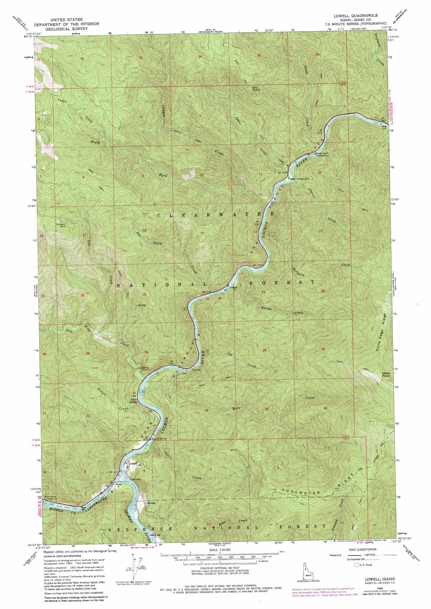
Lowell Topo Map Idaho
To zoom in, hover over the map of Lowell
USGS Topo Quad 46115b5 - 1:24,000 scale
| Topo Map Name: | Lowell |
| USGS Topo Quad ID: | 46115b5 |
| Print Size: | ca. 21 1/4" wide x 27" high |
| Southeast Coordinates: | 46.125° N latitude / 115.5° W longitude |
| Map Center Coordinates: | 46.1875° N latitude / 115.5625° W longitude |
| U.S. State: | ID |
| Filename: | o46115b5.jpg |
| Download Map JPG Image: | Lowell topo map 1:24,000 scale |
| Map Type: | Topographic |
| Topo Series: | 7.5´ |
| Map Scale: | 1:24,000 |
| Source of Map Images: | United States Geological Survey (USGS) |
| Alternate Map Versions: |
Lowell ID 1966, updated 1968 Download PDF Buy paper map Lowell ID 1966, updated 1984 Download PDF Buy paper map Lowell ID 1994, updated 1997 Download PDF Buy paper map Lowell ID 2011 Download PDF Buy paper map Lowell ID 2013 Download PDF Buy paper map |
| FStopo: | US Forest Service topo Lowell is available: Download FStopo PDF Download FStopo TIF |
1:24,000 Topo Quads surrounding Lowell
Pierce |
Hemlock Butte |
Snowy Summit |
Weitas Butte |
Liz Butte |
Brown Creek Ridge |
Musselshell |
Boundary Peak |
Mclendon Butte |
Huckleberry Butte |
Glenwood |
Syringa |
Lowell |
Coolwater Mountain |
Chimney Peak |
Big Cedar |
Lodge Point |
Goddard Point |
Stillman Point |
Selway Falls |
Corral Hill |
Pilot Knob |
Iron Mountain |
Lick Point |
Anderson Butte |
> Back to 46115a1 at 1:100,000 scale
> Back to 46114a1 at 1:250,000 scale
> Back to U.S. Topo Maps home
Lowell topo map: Gazetteer
Lowell: Cliffs
Dry Point elevation 1226m 4022′Idaho Point elevation 1831m 6007′
Lowell: Mines
Chitwood Mine elevation 1291m 4235′Lowell: Populated Places
Lowell elevation 453m 1486′Lowell: Ridges
Coolwater Ridge elevation 1590m 5216′Lowell: Springs
Icicle Spring elevation 461m 1512′Lowell: Streams
Apgar Creek elevation 491m 1610′Cabin Creek elevation 1136m 3727′
Canyon Creek elevation 478m 1568′
Cat Creek elevation 457m 1499′
Chance Creek elevation 481m 1578′
Deadman Creek elevation 495m 1624′
Glade Creek elevation 491m 1610′
Handy Creek elevation 468m 1535′
Hellgate Creek elevation 473m 1551′
Kerr Creek elevation 457m 1499′
Lochsa River elevation 443m 1453′
Lottie Creek elevation 450m 1476′
Lowell Creek elevation 457m 1499′
Nut Creek elevation 505m 1656′
Pete King Creek elevation 452m 1482′
Rye Patch Creek elevation 466m 1528′
Selway River elevation 443m 1453′
South Fork Canyon Creek elevation 536m 1758′
Lowell digital topo map on disk
Buy this Lowell topo map showing relief, roads, GPS coordinates and other geographical features, as a high-resolution digital map file on DVD: