Huckleberry Butte Topo Map Idaho
To zoom in, hover over the map of Huckleberry Butte
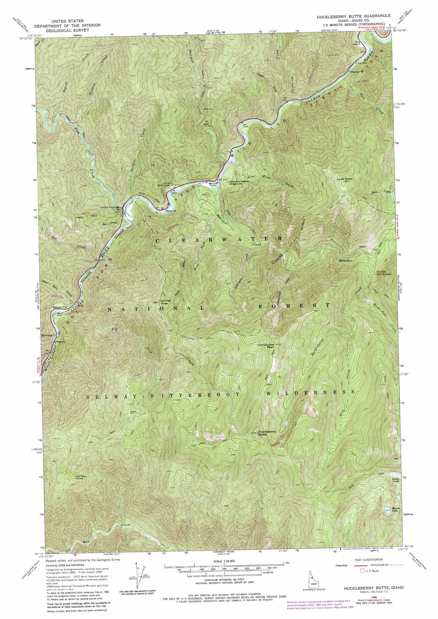
USGS Topo Quad 46115c3 - 1:24,000 scale
| Topo Map Name: | Huckleberry Butte |
| USGS Topo Quad ID: | 46115c3 |
| Print Size: | ca. 21 1/4" wide x 27" high |
| Southeast Coordinates: | 46.25° N latitude / 115.25° W longitude |
| Map Center Coordinates: | 46.3125° N latitude / 115.3125° W longitude |
| U.S. State: | ID |
| Filename: | o46115c3.jpg |
| Download Map JPG Image: | Huckleberry Butte topo map 1:24,000 scale |
| Map Type: | Topographic |
| Topo Series: | 7.5´ |
| Map Scale: | 1:24,000 |
| Source of Map Images: | United States Geological Survey (USGS) |
| Alternate Map Versions: |
Huckleberry Butte ID 1966, updated 1969 Download PDF Buy paper map Huckleberry Butte ID 1966, updated 1980 Download PDF Buy paper map Huckleberry Butte ID 1966, updated 1984 Download PDF Buy paper map Huckleberry Butte ID 1994, updated 1997 Download PDF Buy paper map Huckleberry Butte ID 2011 Download PDF Buy paper map Huckleberry Butte ID 2014 Download PDF Buy paper map |
| FStopo: | US Forest Service topo Huckleberry Butte is available: Download FStopo PDF Download FStopo TIF |
1:24,000 Topo Quads surrounding Huckleberry Butte
Larch Butte |
Lean-To Point |
Cook Mountain |
Lookout Peak |
Horseshoe Lake |
Snowy Summit |
Weitas Butte |
Liz Butte |
Holly Creek |
Greystone Butte |
Boundary Peak |
Mclendon Butte |
Huckleberry Butte |
Greenside Butte |
Fish Lake |
Lowell |
Coolwater Mountain |
Chimney Peak |
Fenn Mountain |
Big Rock Mountain |
Goddard Point |
Stillman Point |
Selway Falls |
Fog Mountain |
Mink Peak |
> Back to 46115a1 at 1:100,000 scale
> Back to 46114a1 at 1:250,000 scale
> Back to U.S. Topo Maps home
Huckleberry Butte topo map: Gazetteer
Huckleberry Butte: Cliffs
Old Man Point elevation 1514m 4967′Huckleberry Butte: Flats
Beaver Flat elevation 585m 1919′Boulder Flat elevation 627m 2057′
Huckleberry Butte: Lakes
Lottie Lake elevation 1872m 6141′Maude Lake elevation 1849m 6066′
Huckleberry Butte: Springs
Stanley Hot Springs elevation 1092m 3582′Huckleberry Butte: Streams
Bee Creek elevation 615m 2017′Big Stew Creek elevation 582m 1909′
Boulder Creek elevation 670m 2198′
Cantaloupe Creek elevation 890m 2919′
Dipper Creek elevation 671m 2201′
Eel Creek elevation 607m 1991′
Fish Creek elevation 614m 2014′
Grit Creek elevation 1337m 4386′
Huckleberry Creek elevation 1046m 3431′
Lone Knob Creek elevation 634m 2080′
No-see-um Creek elevation 660m 2165′
Otter Slide Creek elevation 594m 1948′
Pagoda Creek elevation 774m 2539′
Pass Creek elevation 669m 2194′
Pondosa Creek elevation 746m 2447′
Rock Lake Creek elevation 1154m 3786′
Sardine Creek elevation 610m 2001′
Sherman Creek elevation 637m 2089′
Snowshoe Creek elevation 585m 1919′
West Fork Boulder Creek elevation 669m 2194′
Huckleberry Butte: Summits
Huckleberry Butte elevation 2038m 6686′Lochsa Peak elevation 1488m 4881′
Lone Knob elevation 1653m 5423′
Huckleberry Butte digital topo map on disk
Buy this Huckleberry Butte topo map showing relief, roads, GPS coordinates and other geographical features, as a high-resolution digital map file on DVD: