Diamond Peak Topo Map Washington
To zoom in, hover over the map of Diamond Peak
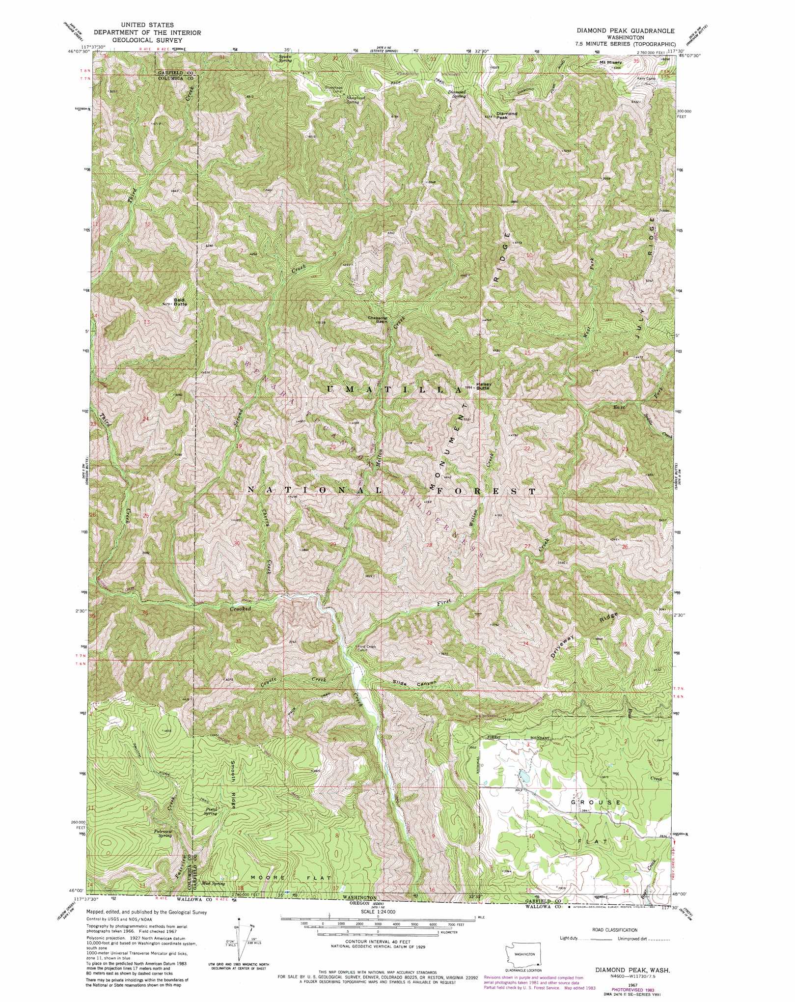
USGS Topo Quad 46117a5 - 1:24,000 scale
| Topo Map Name: | Diamond Peak |
| USGS Topo Quad ID: | 46117a5 |
| Print Size: | ca. 21 1/4" wide x 27" high |
| Southeast Coordinates: | 46° N latitude / 117.5° W longitude |
| Map Center Coordinates: | 46.0625° N latitude / 117.5625° W longitude |
| U.S. State: | WA |
| Filename: | o46117a5.jpg |
| Download Map JPG Image: | Diamond Peak topo map 1:24,000 scale |
| Map Type: | Topographic |
| Topo Series: | 7.5´ |
| Map Scale: | 1:24,000 |
| Source of Map Images: | United States Geological Survey (USGS) |
| Alternate Map Versions: |
Diamond Peak WA 1967, updated 1971 Download PDF Buy paper map Diamond Peak WA 1967, updated 1980 Download PDF Buy paper map Diamond Peak WA 1967, updated 1983 Download PDF Buy paper map Diamond Peak WA 1995, updated 1998 Download PDF Buy paper map Diamond Peak WA 2011 Download PDF Buy paper map Diamond Peak WA 2013 Download PDF Buy paper map |
| FStopo: | US Forest Service topo Diamond Peak is available: Download FStopo PDF Download FStopo TIF |
1:24,000 Topo Quads surrounding Diamond Peak
Cahill Mountain |
Hopkins Ridge |
Rose Springs |
Peola |
Potter Hill |
Eckler Mountain |
Panjab Creek |
Stentz Spring |
Pinkham Butte |
Harlow Ridge |
Godman Spring |
Oregon Butte |
Diamond Peak |
Saddle Butte |
Mountain View |
Wenaha Forks |
Elbow Creek |
Eden |
Troy |
Flora |
Fry Meadow |
Deep Creek |
Promise |
Wood Butte |
Shamrock Creek |
> Back to 46117a1 at 1:100,000 scale
> Back to 46116a1 at 1:250,000 scale
> Back to U.S. Topo Maps home
Diamond Peak topo map: Gazetteer
Diamond Peak: Basins
Chaparral Basin elevation 1089m 3572′Diamond Peak: Ridges
July Ridge elevation 1585m 5200′Monument Ridge elevation 1623m 5324′
Smooth Ridge elevation 1223m 4012′
Diamond Peak: Springs
Diamond Spring elevation 1863m 6112′Fairview Spring elevation 1093m 3585′
Mud Spring elevation 1095m 3592′
Pistol Spring elevation 1207m 3959′
Sheephead Spring elevation 1806m 5925′
Squaw Spring elevation 1828m 5997′
Diamond Peak: Streams
Cherry Creek elevation 740m 2427′Coyote Creek elevation 691m 2267′
East Fork First Creek elevation 968m 3175′
First Creek elevation 692m 2270′
Melton Creek elevation 725m 2378′
Saddle Creek elevation 1019m 3343′
Second Creek elevation 767m 2516′
Third Creek elevation 822m 2696′
West Fork First Creek elevation 968m 3175′
Willow Creek elevation 770m 2526′
Diamond Peak: Summits
Bald Butte elevation 1664m 5459′Diamond Peak elevation 1935m 6348′
Halsey Butte elevation 1623m 5324′
Mount Misery elevation 1941m 6368′
Diamond Peak: Trails
Crooked Creek Trail elevation 741m 2431′July Ridge Trail elevation 1686m 5531′
Melton Creek Trail elevation 1247m 4091′
Packer Trail elevation 1301m 4268′
Diamond Peak: Valleys
Slide Canyon elevation 695m 2280′Diamond Peak digital topo map on disk
Buy this Diamond Peak topo map showing relief, roads, GPS coordinates and other geographical features, as a high-resolution digital map file on DVD: