Knife River Mine Topo Map Montana
To zoom in, hover over the map of Knife River Mine
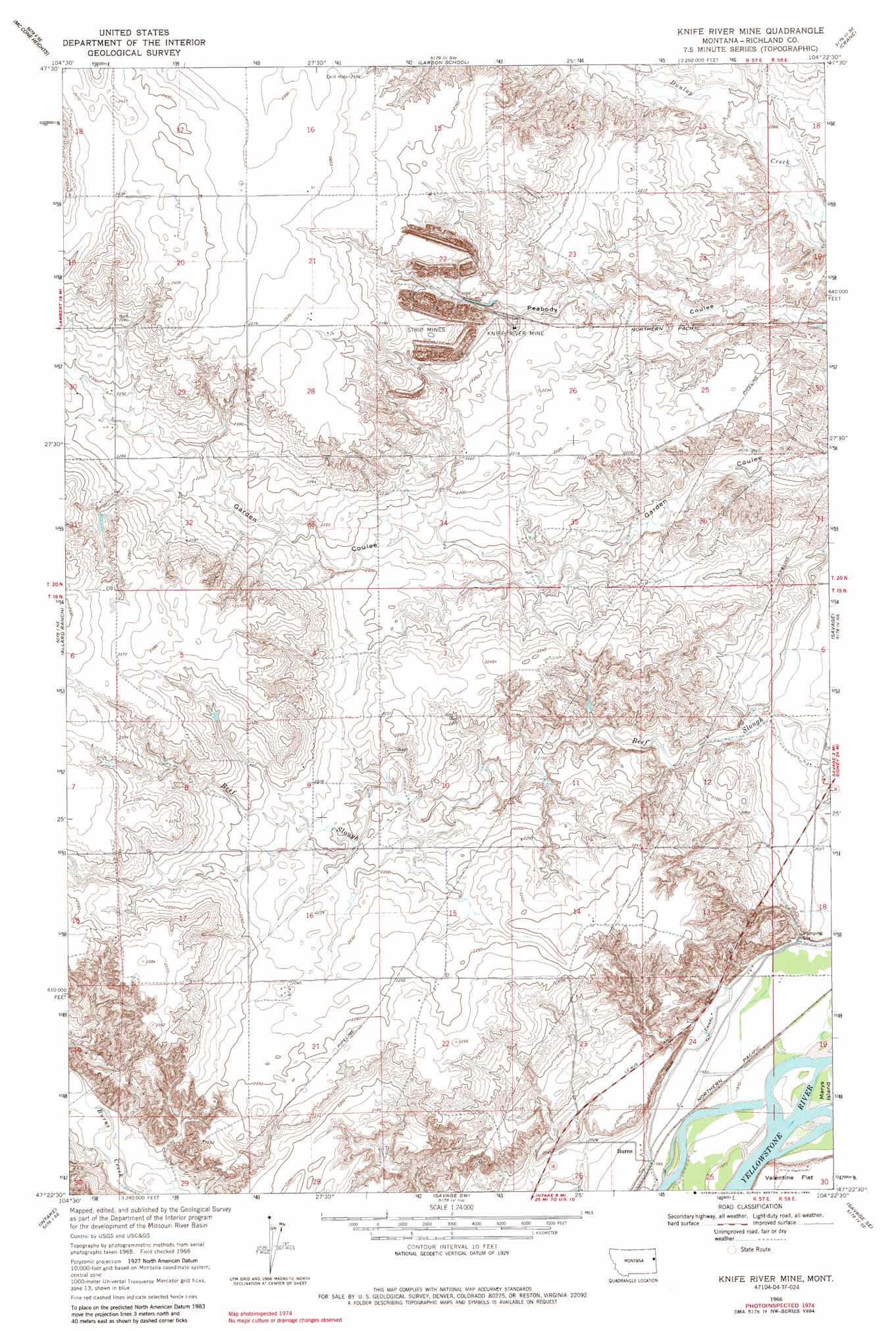
USGS Topo Quad 47104d4 - 1:24,000 scale
| Topo Map Name: | Knife River Mine |
| USGS Topo Quad ID: | 47104d4 |
| Print Size: | ca. 21 1/4" wide x 27" high |
| Southeast Coordinates: | 47.375° N latitude / 104.375° W longitude |
| Map Center Coordinates: | 47.4375° N latitude / 104.4375° W longitude |
| U.S. State: | MT |
| Filename: | o47104d4.jpg |
| Download Map JPG Image: | Knife River Mine topo map 1:24,000 scale |
| Map Type: | Topographic |
| Topo Series: | 7.5´ |
| Map Scale: | 1:24,000 |
| Source of Map Images: | United States Geological Survey (USGS) |
| Alternate Map Versions: |
Knife River Mine MT 1966, updated 1970 Download PDF Buy paper map Knife River Mine MT 1966, updated 1984 Download PDF Buy paper map Knife River Mine MT 2011 Download PDF Buy paper map Knife River Mine MT 2014 Download PDF Buy paper map |
1:24,000 Topo Quads surrounding Knife River Mine
Fox Lake |
Lambert |
Crane Nw |
Crane Ne |
Sidney |
Butler Table |
Mccone Heights |
Larson School |
Crane |
Piche |
Intake Nw |
Allard Ranch |
Knife River Mine |
Savage |
Skaar Nw |
Kolberg Ranch |
Intake |
Savage Sw |
Savage Se |
Parson Creek |
Stipek |
Belle Prairie |
Cluster Buttes Nw |
Cluster Buttes |
Odland Dam Nw |
> Back to 47104a1 at 1:100,000 scale
> Back to 47104a1 at 1:250,000 scale
> Back to U.S. Topo Maps home
Knife River Mine topo map: Gazetteer
Knife River Mine: Islands
Gros Ventre Island elevation 596m 1955′Knife River Mine: Mines
Knife River Mine elevation 690m 2263′Knife River Mine: Populated Places
Burns elevation 601m 1971′Knife River Mine: Post Offices
Burns Post Office (historical) elevation 601m 1971′Knife River Mine: Wells
19N57E08ACCC01 Well elevation 697m 2286′19N57E13AB__01 Well elevation 655m 2148′
19N57E14BD__01 Well elevation 685m 2247′
19N57E21BABB01 Well elevation 684m 2244′
19N57E24AC__01 Well elevation 603m 1978′
19N57E25BB__01 Well elevation 605m 1984′
19N57E26AD__01 Well elevation 610m 2001′
19N58E06BA__01 Well elevation 621m 2037′
19N58E07BD__01 Well elevation 612m 2007′
19N58E07BD__02 Well elevation 612m 2007′
19N58E18BA__01 Well elevation 617m 2024′
19N58E18CC__01 Well elevation 598m 1961′
19N58E18CD__01 Well elevation 597m 1958′
20N57E13BD__01 Well elevation 645m 2116′
20N57E16CDDD01 Well elevation 726m 2381′
20N57E21CDDA01 Well elevation 726m 2381′
20N57E22DD__01 Well elevation 696m 2283′
20N57E27DC__01 Well elevation 679m 2227′
20N57E27DCDC01 Well elevation 683m 2240′
20N57E30DDAB01 Well elevation 693m 2273′
Knife River Mine digital topo map on disk
Buy this Knife River Mine topo map showing relief, roads, GPS coordinates and other geographical features, as a high-resolution digital map file on DVD:
Eastern Montana & Western North Dakota
Buy digital topo maps: Eastern Montana & Western North Dakota