Elwood Topo Map Texas
To zoom in, hover over the map of Elwood
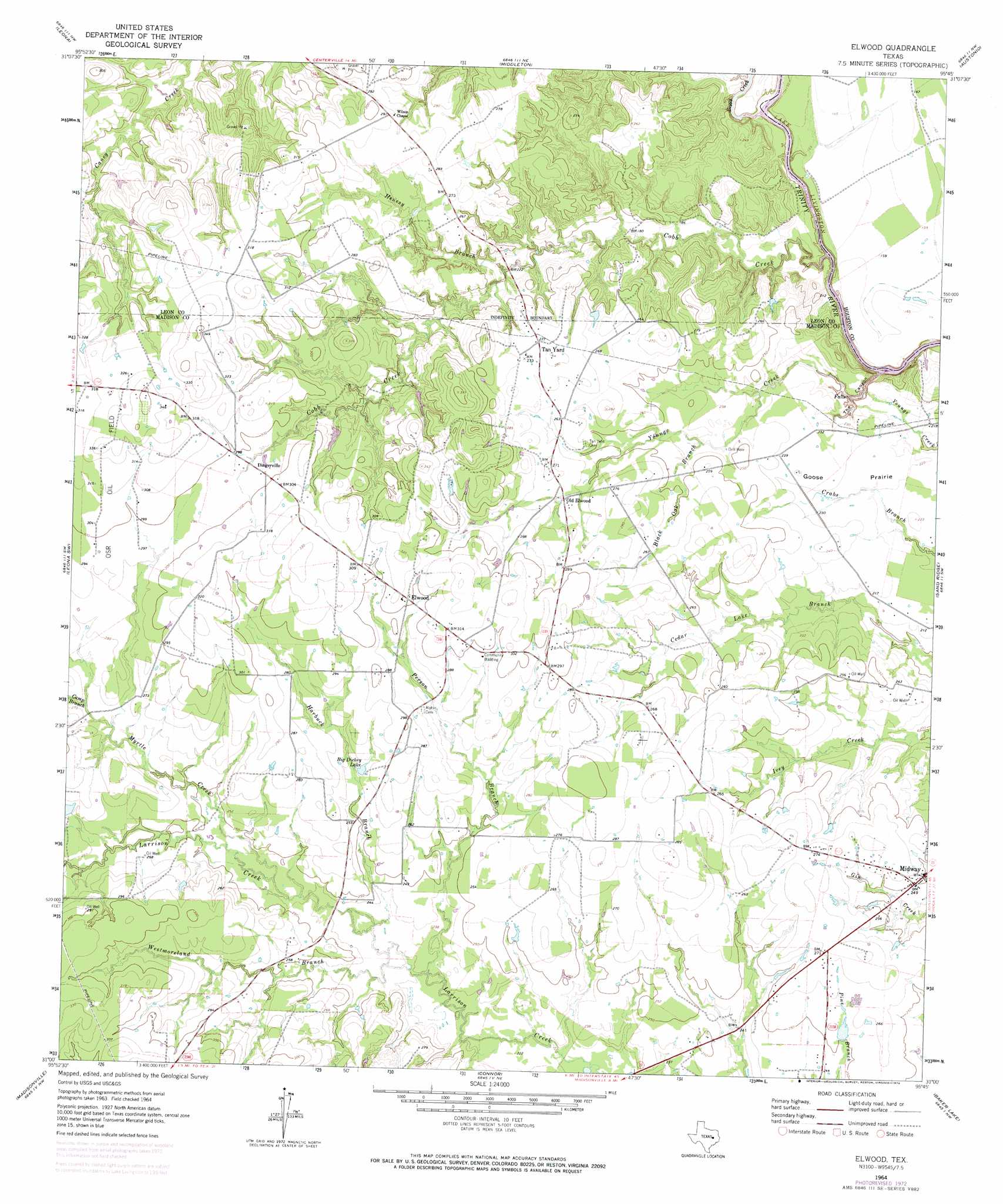
USGS Topo Quad 31095a7 - 1:24,000 scale
| Topo Map Name: | Elwood |
| USGS Topo Quad ID: | 31095a7 |
| Print Size: | ca. 21 1/4" wide x 27" high |
| Southeast Coordinates: | 31° N latitude / 95.75° W longitude |
| Map Center Coordinates: | 31.0625° N latitude / 95.8125° W longitude |
| U.S. State: | TX |
| Filename: | o31095a7.jpg |
| Download Map JPG Image: | Elwood topo map 1:24,000 scale |
| Map Type: | Topographic |
| Topo Series: | 7.5´ |
| Map Scale: | 1:24,000 |
| Source of Map Images: | United States Geological Survey (USGS) |
| Alternate Map Versions: |
Elwood TX 1964, updated 1967 Download PDF Buy paper map Elwood TX 1964, updated 1974 Download PDF Buy paper map Elwood TX 2010 Download PDF Buy paper map Elwood TX 2013 Download PDF Buy paper map Elwood TX 2016 Download PDF Buy paper map |
1:24,000 Topo Quads surrounding Elwood
Robbins |
Centerville |
Eunice |
Halls Bluff |
Porter Springs |
Spring Seat |
Leona |
Middleton |
Austonio |
Pearsons Chapel |
Normangee |
Leona Sw |
Elwood |
Sand Ridge |
Weldon |
North Zulch |
Madisonville |
Connor |
Baker Lake |
Wyser Bottom |
Iola |
Bedias |
Steep Branch |
Crabbs Prairie |
Pine Prairie |
> Back to 31095a1 at 1:100,000 scale
> Back to 31094a1 at 1:250,000 scale
> Back to U.S. Topo Maps home
Elwood topo map: Gazetteer
Elwood: Dams
Slaughter Lake Dam elevation 78m 255′Elwood: Flats
Goose Prairie elevation 69m 226′Elwood: Lakes
Big Dickey Lake elevation 81m 265′Elwood: Populated Places
Dingerville elevation 91m 298′Elwood elevation 91m 298′
Midway elevation 76m 249′
Old Elwood elevation 80m 262′
Elwood: Reservoirs
Slaughter Lake elevation 78m 255′Elwood: Streams
Black Oak Branch elevation 69m 226′Boggy Creek elevation 40m 131′
Camp Branch elevation 80m 262′
Cobb Creek elevation 40m 131′
Convict Branch elevation 76m 249′
Harbuck Branch elevation 70m 229′
Henesy Branch elevation 66m 216′
Little Spring Branch elevation 73m 239′
Myrtle Creek elevation 73m 239′
Person Branch elevation 67m 219′
Westmoreland Branch elevation 70m 229′
Elwood: Valleys
The Canyon elevation 40m 131′Elwood digital topo map on disk
Buy this Elwood topo map showing relief, roads, GPS coordinates and other geographical features, as a high-resolution digital map file on DVD: