Rincon Topo Map Georgia
To zoom in, hover over the map of Rincon
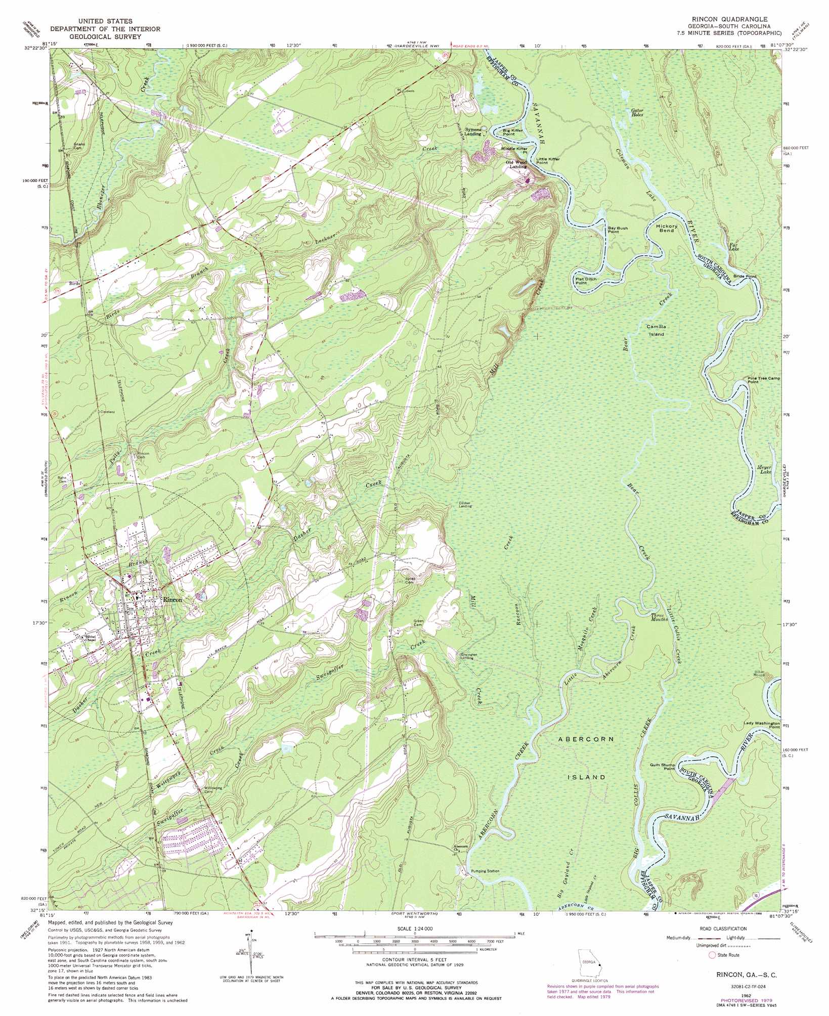
USGS Topo Quad 32081c2 - 1:24,000 scale
| Topo Map Name: | Rincon |
| USGS Topo Quad ID: | 32081c2 |
| Print Size: | ca. 21 1/4" wide x 27" high |
| Southeast Coordinates: | 32.25° N latitude / 81.125° W longitude |
| Map Center Coordinates: | 32.3125° N latitude / 81.1875° W longitude |
| U.S. States: | GA, SC |
| Filename: | o32081c2.jpg |
| Download Map JPG Image: | Rincon topo map 1:24,000 scale |
| Map Type: | Topographic |
| Topo Series: | 7.5´ |
| Map Scale: | 1:24,000 |
| Source of Map Images: | United States Geological Survey (USGS) |
| Alternate Map Versions: |
Rincon GA 1962, updated 1964 Download PDF Buy paper map Rincon GA 1962, updated 1988 Download PDF Buy paper map Rincon GA 2011 Download PDF Buy paper map Rincon GA 2014 Download PDF Buy paper map |
1:24,000 Topo Quads surrounding Rincon
Kildare |
Brighton |
Pineland |
Calfpen Bay |
Coosawhatchie |
Egypt |
Springfield North |
Hardeeville Nw |
Tillman |
Ridgeland |
Guyton |
Springfield South |
Rincon |
Hardeeville |
Jasper |
Eden |
Meldrim |
Port Wentworth |
Limehouse |
Pritchardville |
Meldrim Sw |
Meldrim Se |
Garden City |
Savannah |
Fort Pulaski |
> Back to 32081a1 at 1:100,000 scale
> Back to 32080a1 at 1:250,000 scale
> Back to U.S. Topo Maps home
Rincon topo map: Gazetteer
Rincon: Bays
Coleman Lake elevation 2m 6′Rincon: Capes
Bay Bush Point elevation 3m 9′Big Kiffer Point elevation 4m 13′
Flat Ditch Point elevation 2m 6′
Flat Dutch Point elevation 4m 13′
Glovers Point elevation 2m 6′
Gum Stump Point elevation 1m 3′
Lady Washington Point elevation 2m 6′
Little Kiffer Point elevation 3m 9′
Middle Kiffer Point elevation 3m 9′
Pine Tree Camp Point elevation 2m 6′
Rincon: Crossings
Becks Ferry (historical) elevation 3m 9′Becks Ferry (historical) elevation 3m 9′
Rincon: Lakes
Forks Lake elevation 2m 6′Fox Lake elevation 2m 6′
Gator Holes elevation 2m 6′
Meyer Lake elevation 1m 3′
Rincon: Populated Places
Birds elevation 20m 65′Goshen Villa elevation 17m 55′
Rincon elevation 22m 72′
Silverwood Plantation elevation 17m 55′
Willowpeg elevation 19m 62′
Rincon: Streams
Bear Creek elevation 1m 3′Big Collis Creek elevation 0m 0′
Big Gayland Creek elevation 0m 0′
Birds Branch elevation 9m 29′
Coleman Run elevation 2m 6′
Dasher Creek elevation 2m 6′
Little Abercorn Creek elevation 0m 0′
Little Collis Creek elevation 0m 0′
Little Gayland Creek elevation 0m 0′
Lockner Creek elevation 2m 6′
Mill Creek elevation 1m 3′
Mosquito Creek elevation 1m 3′
Polly Creek elevation 9m 29′
Raccoon Creek elevation 1m 3′
Rincon Branch elevation 10m 32′
Sweigoffer Creek elevation 1m 3′
Willowpeg Creek elevation 6m 19′
Rincon digital topo map on disk
Buy this Rincon topo map showing relief, roads, GPS coordinates and other geographical features, as a high-resolution digital map file on DVD:
South Carolina, Western North Carolina & Northeastern Georgia
Buy digital topo maps: South Carolina, Western North Carolina & Northeastern Georgia