Pearl River Topo Map Mississippi
To zoom in, hover over the map of Pearl River
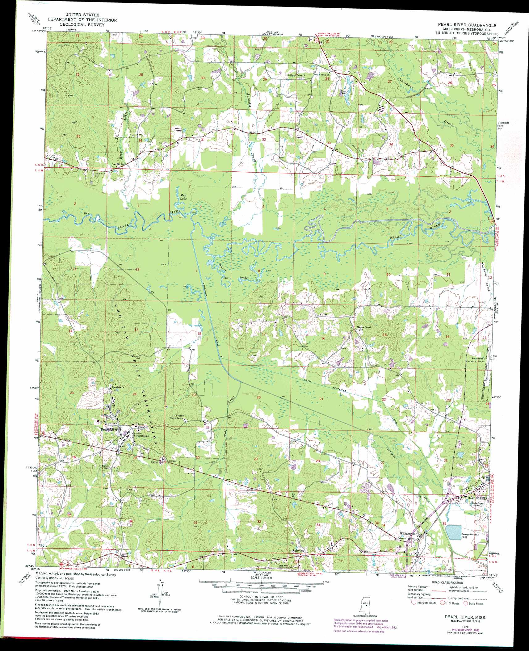
USGS Topo Quad 32089g2 - 1:24,000 scale
| Topo Map Name: | Pearl River |
| USGS Topo Quad ID: | 32089g2 |
| Print Size: | ca. 21 1/4" wide x 27" high |
| Southeast Coordinates: | 32.75° N latitude / 89.125° W longitude |
| Map Center Coordinates: | 32.8125° N latitude / 89.1875° W longitude |
| U.S. State: | MS |
| Filename: | o32089g2.jpg |
| Download Map JPG Image: | Pearl River topo map 1:24,000 scale |
| Map Type: | Topographic |
| Topo Series: | 7.5´ |
| Map Scale: | 1:24,000 |
| Source of Map Images: | United States Geological Survey (USGS) |
| Alternate Map Versions: |
Pearl River MS 1972, updated 1973 Download PDF Buy paper map Pearl River MS 1972, updated 1982 Download PDF Buy paper map Pearl River MS 2012 Download PDF Buy paper map Pearl River MS 2015 Download PDF Buy paper map |
1:24,000 Topo Quads surrounding Pearl River
Ethel South |
Ethel Se |
Louisville Sw |
Louisville South |
Boon |
Zama |
Four Corners |
Plattsburg |
Noxapater |
Vernon |
Renfroe |
Edinburg |
Pearl River |
Philadelphia |
Owl Creek |
Mcafee |
Madden |
Mcdonald |
Deemer |
House |
Walnut Grove |
Sebastopol |
Union West |
Union East |
Post |
> Back to 32089e1 at 1:100,000 scale
> Back to 32088a1 at 1:250,000 scale
> Back to U.S. Topo Maps home
Pearl River topo map: Gazetteer
Pearl River: Airports
Philadelphia Municipal Airport elevation 136m 446′Pearl River: Canals
Kentawka Canal elevation 116m 380′Little Kentawka Canal elevation 118m 387′
Pearl River: Dams
Grover Willis Lake Dam elevation 134m 439′Philadelphia Sewage Lagoon Dam elevation 122m 400′
Pearl River: Lakes
Mud Lake elevation 113m 370′Myers Lake elevation 112m 367′
Pearl River: Populated Places
Fairview elevation 170m 557′Pearl River elevation 159m 521′
Williamsville elevation 122m 400′
Zaphyr Hill elevation 159m 521′
Pearl River: Streams
Bear Creek elevation 113m 370′Bogue Kentawka elevation 113m 370′
Funny Yockana Creek elevation 119m 390′
Jofuska Creek elevation 113m 370′
Wolf Creek elevation 115m 377′
Woodard Creek elevation 115m 377′
Pearl River digital topo map on disk
Buy this Pearl River topo map showing relief, roads, GPS coordinates and other geographical features, as a high-resolution digital map file on DVD:
Gulf Coast (LA, MS, AL, FL) & Southwestern Georgia
Buy digital topo maps: Gulf Coast (LA, MS, AL, FL) & Southwestern Georgia
 & Southwestern Georgia map DVD")