Italy Topo Map Texas
To zoom in, hover over the map of Italy
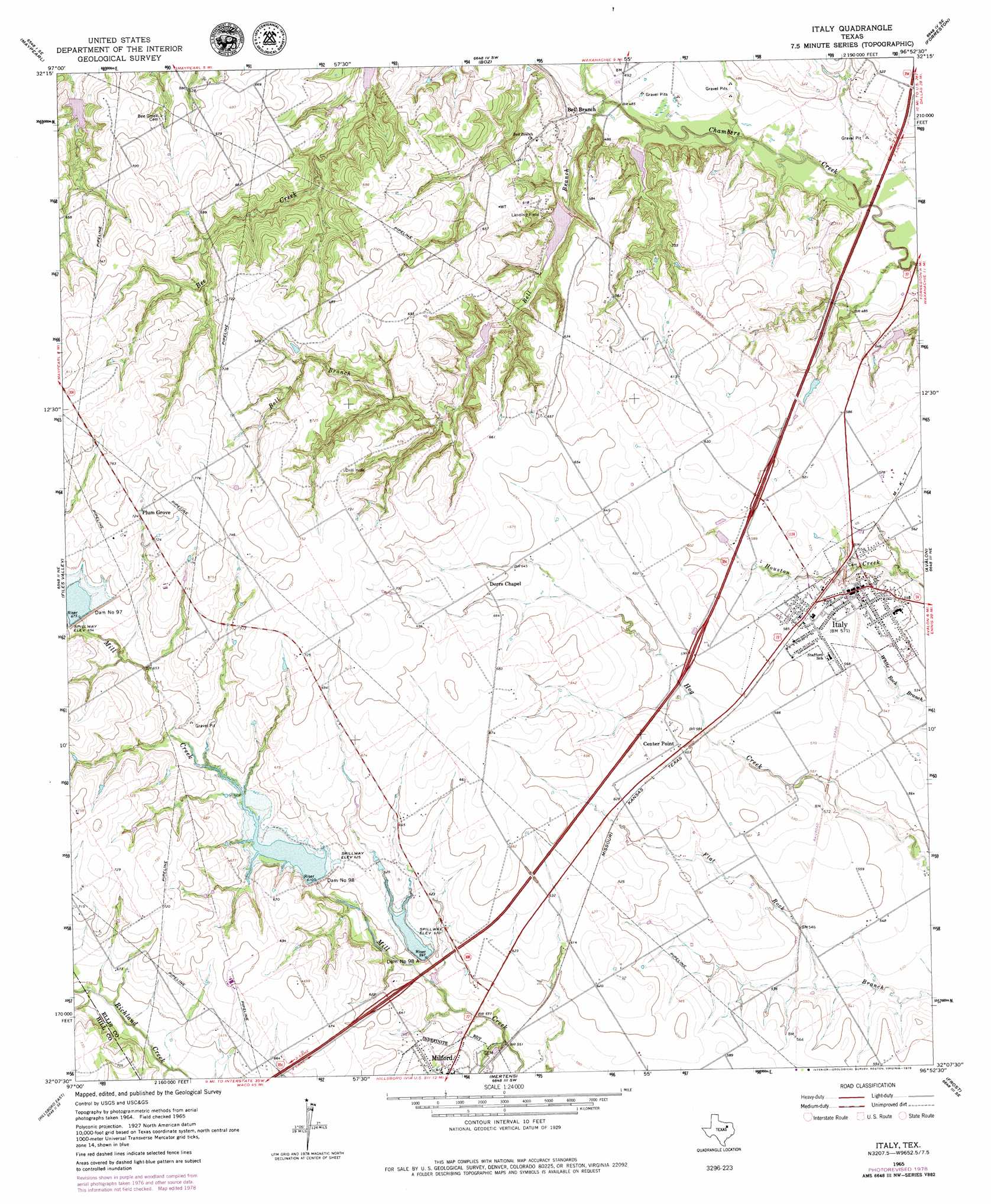
USGS Topo Quad 32096b8 - 1:24,000 scale
| Topo Map Name: | Italy |
| USGS Topo Quad ID: | 32096b8 |
| Print Size: | ca. 21 1/4" wide x 27" high |
| Southeast Coordinates: | 32.125° N latitude / 96.875° W longitude |
| Map Center Coordinates: | 32.1875° N latitude / 96.9375° W longitude |
| U.S. State: | TX |
| Filename: | o32096b8.jpg |
| Download Map JPG Image: | Italy topo map 1:24,000 scale |
| Map Type: | Topographic |
| Topo Series: | 7.5´ |
| Map Scale: | 1:24,000 |
| Source of Map Images: | United States Geological Survey (USGS) |
| Alternate Map Versions: |
Italy TX 1965, updated 1967 Download PDF Buy paper map Italy TX 1965, updated 1979 Download PDF Buy paper map Italy TX 1965, updated 1979 Download PDF Buy paper map Italy TX 2010 Download PDF Buy paper map Italy TX 2012 Download PDF Buy paper map Italy TX 2016 Download PDF Buy paper map |
1:24,000 Topo Quads surrounding Italy
Alvarado |
Venus |
Midlothian |
Waxahachie |
Palmer |
Grandview |
Maypearl |
Boz |
Forreston |
Ennis West |
Itasca |
Files Valley |
Italy |
Avalon |
Cryer Creek |
Hillsboro West |
Hillsboro East |
Mertens |
Frost |
Blooming Grove |
Peoria |
Abbott |
Malone |
Irene |
Dawson |
> Back to 32096a1 at 1:100,000 scale
> Back to 32096a1 at 1:250,000 scale
> Back to U.S. Topo Maps home
Italy topo map: Gazetteer
Italy: Airports
Dale Acres Airport elevation 203m 666′Hirok Airport elevation 216m 708′
Italy: Dams
Bell Branch Ranch Dam elevation 163m 534′Dam Number 97 elevation 211m 692′
Dam Number 98 elevation 194m 636′
Dam Number 98A elevation 184m 603′
Soil Conservation Service Site 79a Dam elevation 180m 590′
Soil Conservation Service Site 83 Dam elevation 153m 501′
Soil Conservation Service Site 85b Dam elevation 173m 567′
Soil Conservation Service Site 86 Dam elevation 153m 501′
Soil Conservation Service Site 97 Dam elevation 206m 675′
Soil Conservation Service Site 98 Dam elevation 186m 610′
Soil Conservation Service Site 98a Dam elevation 182m 597′
Italy: Populated Places
Bell Branch elevation 157m 515′Italy elevation 174m 570′
Plum Grove elevation 220m 721′
Italy: Reservoirs
Bell Branch Ranch Lake elevation 163m 534′Soil Conservation Service Site 79a Reservoir elevation 180m 590′
Soil Conservation Service Site 83 Reservoir elevation 153m 501′
Soil Conservation Service Site 85b Reservoir elevation 173m 567′
Soil Conservation Service Site 86 Reservoir elevation 153m 501′
Soil Conservation Service Site 97 Reservoir elevation 206m 675′
Soil Conservation Service Site 98 Reservoir elevation 186m 610′
Soil Conservation Service Site 98a Reservoir elevation 182m 597′
Italy: Streams
Bell Branch elevation 140m 459′Italy digital topo map on disk
Buy this Italy topo map showing relief, roads, GPS coordinates and other geographical features, as a high-resolution digital map file on DVD: