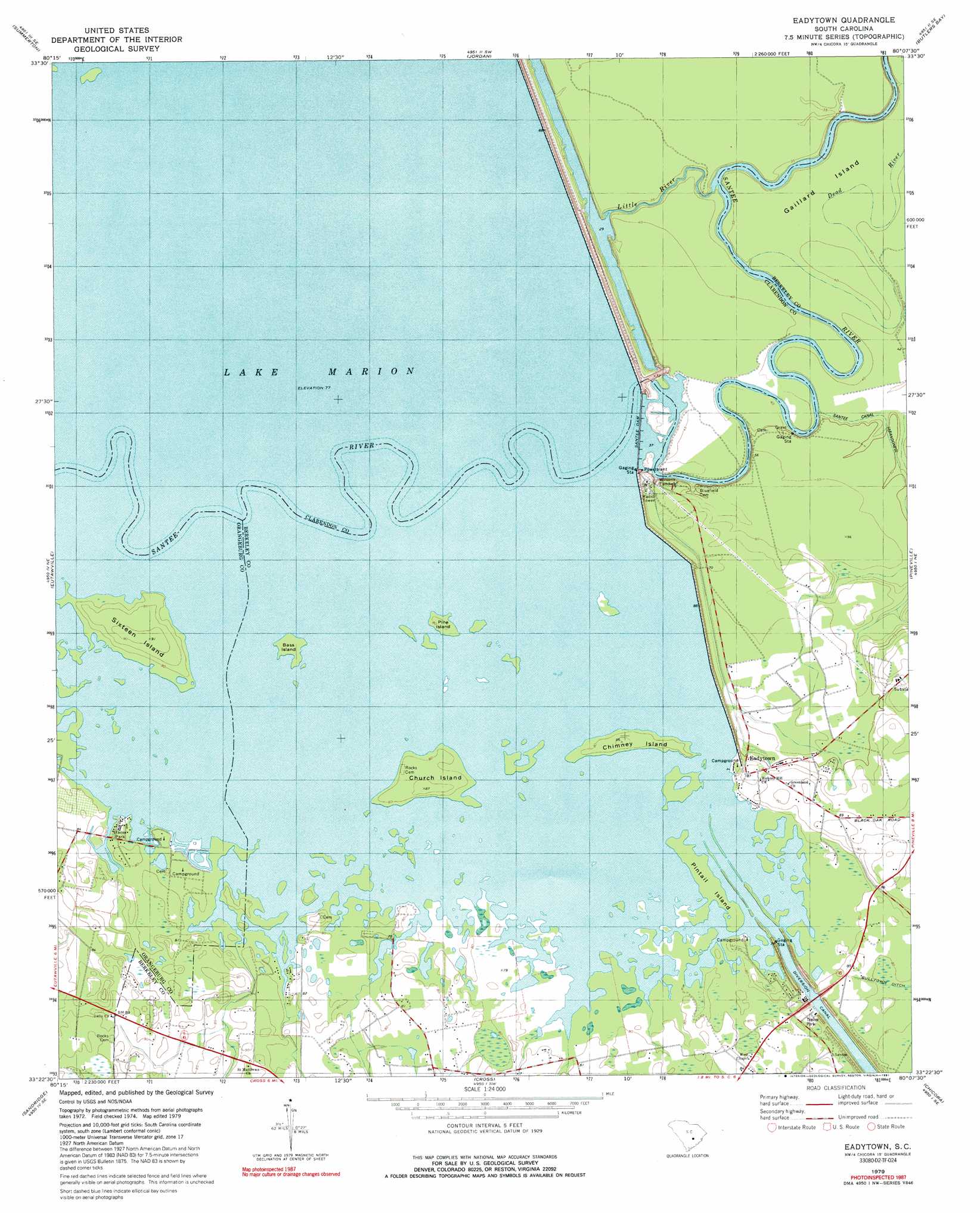
Eadytown Topo Map South Carolina
To zoom in, hover over the map of Eadytown
USGS Topo Quad 33080d2 - 1:24,000 scale
| Topo Map Name: | Eadytown |
| USGS Topo Quad ID: | 33080d2 |
| Print Size: | ca. 21 1/4" wide x 27" high |
| Southeast Coordinates: | 33.375° N latitude / 80.125° W longitude |
| Map Center Coordinates: | 33.4375° N latitude / 80.1875° W longitude |
| U.S. State: | SC |
| Filename: | o33080d2.jpg |
| Download Map JPG Image: | Eadytown topo map 1:24,000 scale |
| Map Type: | Topographic |
| Topo Series: | 7.5´ |
| Map Scale: | 1:24,000 |
| Source of Map Images: | United States Geological Survey (USGS) |
| Alternate Map Versions: |
Eadytown SC 1979, updated 1980 Download PDF Buy paper map Eadytown SC 1979, updated 1981 Download PDF Buy paper map Eadytown SC 2011 Download PDF Buy paper map Eadytown SC 2014 Download PDF Buy paper map |
1:24,000 Topo Quads surrounding Eadytown
Pinewood |
Paxville |
Manning |
Foreston |
Workman |
Saint Paul |
Summerton |
Jordan |
Butlers Bay |
Greeleyville |
Vance |
Eutawville |
Eadytown |
Pineville |
Saint Stephens |
Holly Hill |
Sandridge |
Cross |
Chicora |
Bonneau |
Harleyville |
Pringletown |
Summerville Nw |
Moncks Corner |
Cordesville |
> Back to 33080a1 at 1:100,000 scale
> Back to 33080a1 at 1:250,000 scale
> Back to U.S. Topo Maps home
Eadytown topo map: Gazetteer
Eadytown: Dams
Santee Dam elevation 13m 42′South Carolina Noname 14016 Dam elevation 23m 75′
Eadytown: Islands
Bass Island elevation 24m 78′Blackoak Island (historical) elevation 23m 75′
Chimney Island elevation 26m 85′
Church Island elevation 25m 82′
Gaillard Island elevation 11m 36′
Pine Island elevation 24m 78′
Pintail Island elevation 24m 78′
Sixteen Island elevation 27m 88′
Eadytown: Lakes
Irvin Lake (historical) elevation 23m 75′Pine Grove Lake (historical) elevation 23m 75′
Eadytown: Populated Places
Corsada (historical) elevation 24m 78′Eadytown elevation 26m 85′
Moss Pond (historical) elevation 24m 78′
Spring Plain (historical) elevation 24m 78′
Wilsons Landing elevation 13m 42′
Eadytown: Reservoirs
Lake Marion elevation 13m 42′Eadytown: Streams
Little River elevation 8m 26′Rocks Creek (historical) elevation 23m 75′
Eadytown: Swamps
Cherry Grove Swamp (historical) elevation 23m 75′Greenland Swamp (historical) elevation 23m 75′
Springwood Swamp (historical) elevation 24m 78′
Eadytown digital topo map on disk
Buy this Eadytown topo map showing relief, roads, GPS coordinates and other geographical features, as a high-resolution digital map file on DVD:
South Carolina, Western North Carolina & Northeastern Georgia
Buy digital topo maps: South Carolina, Western North Carolina & Northeastern Georgia