Montpelier Topo Map Mississippi
To zoom in, hover over the map of Montpelier
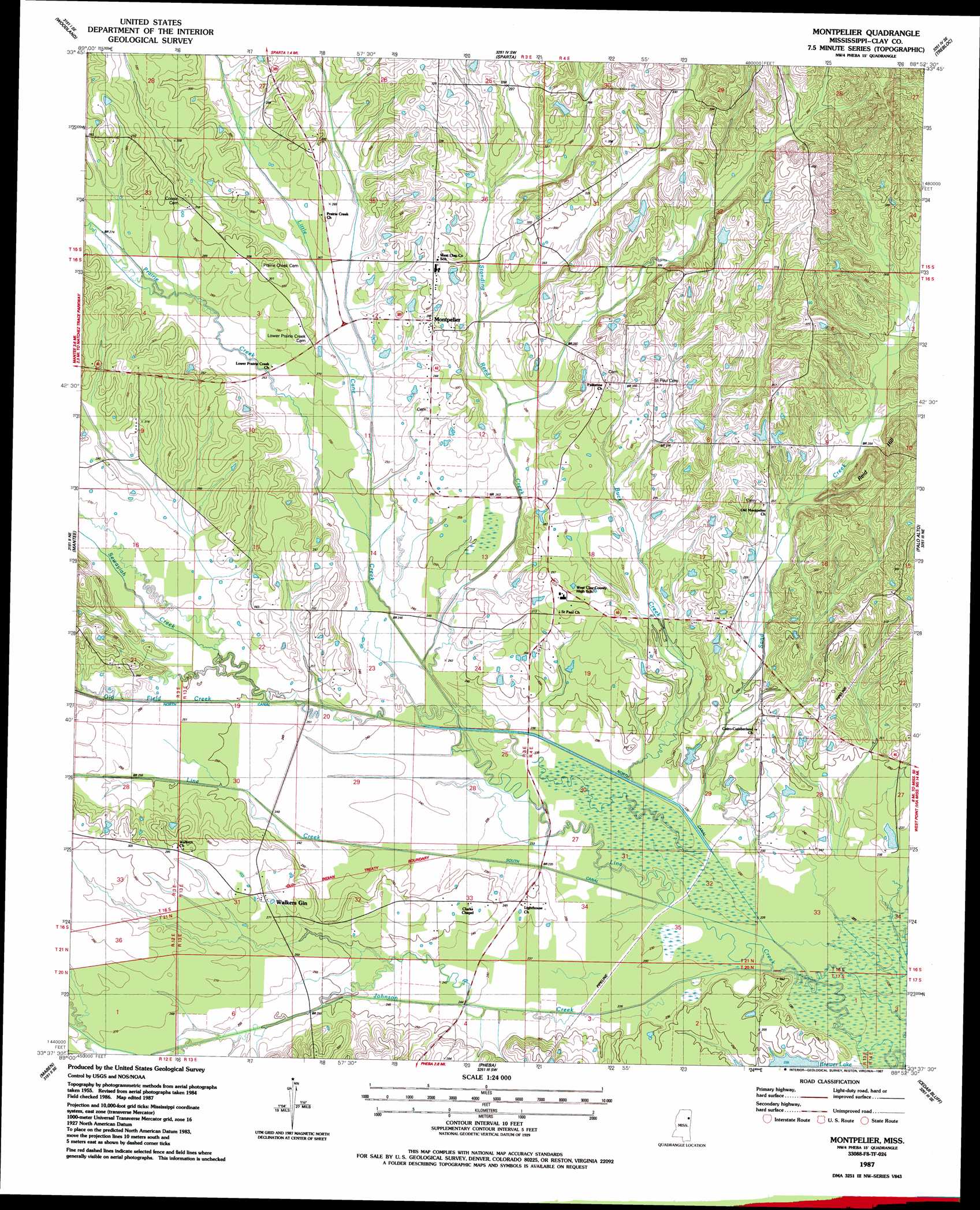
USGS Topo Quad 33088f8 - 1:24,000 scale
| Topo Map Name: | Montpelier |
| USGS Topo Quad ID: | 33088f8 |
| Print Size: | ca. 21 1/4" wide x 27" high |
| Southeast Coordinates: | 33.625° N latitude / 88.875° W longitude |
| Map Center Coordinates: | 33.6875° N latitude / 88.9375° W longitude |
| U.S. State: | MS |
| Filename: | o33088f8.jpg |
| Download Map JPG Image: | Montpelier topo map 1:24,000 scale |
| Map Type: | Topographic |
| Topo Series: | 7.5´ |
| Map Scale: | 1:24,000 |
| Source of Map Images: | United States Geological Survey (USGS) |
| Alternate Map Versions: |
Montpelier MS 1987, updated 1987 Download PDF Buy paper map Montpelier MS 2012 Download PDF Buy paper map Montpelier MS 2015 Download PDF Buy paper map |
1:24,000 Topo Quads surrounding Montpelier
Vardaman |
Houston West |
Houston East |
Buena Vista |
Egypt |
Atlanta |
Woodland |
Sparta |
Trebloc |
Prairie |
Hohenlinden |
Mantee |
Montpelier |
Palo Alto |
Muldon |
Sapa |
Maben |
Pheba |
Cedar Bluff |
West Point |
Reform |
Double Springs |
Longview |
Starkville |
Artesia |
> Back to 33088e1 at 1:100,000 scale
> Back to 33088a1 at 1:250,000 scale
> Back to U.S. Topo Maps home
Montpelier topo map: Gazetteer
Montpelier: Canals
North Canal elevation 72m 236′South Canal elevation 72m 236′
Montpelier: Dams
Brewer Lake Dam elevation 70m 229′Walkers Lake Dam elevation 79m 259′
Montpelier: Populated Places
Beasley elevation 90m 295′Cairo elevation 78m 255′
Montpelier elevation 90m 295′
Palestine elevation 98m 321′
Walkers Gin elevation 83m 272′
Montpelier: Post Offices
Montpelier Post Office elevation 90m 295′Montpelier: Streams
Buck Creek elevation 69m 226′Johnson Creek elevation 70m 229′
Little Cane Creek elevation 69m 226′
Old Field Creek elevation 68m 223′
Prairie Creek elevation 73m 239′
Sand Creek elevation 68m 223′
Sewayiah Creek elevation 76m 249′
Standing Reed Creek elevation 73m 239′
Montpelier digital topo map on disk
Buy this Montpelier topo map showing relief, roads, GPS coordinates and other geographical features, as a high-resolution digital map file on DVD: