Annona Topo Map Texas
To zoom in, hover over the map of Annona
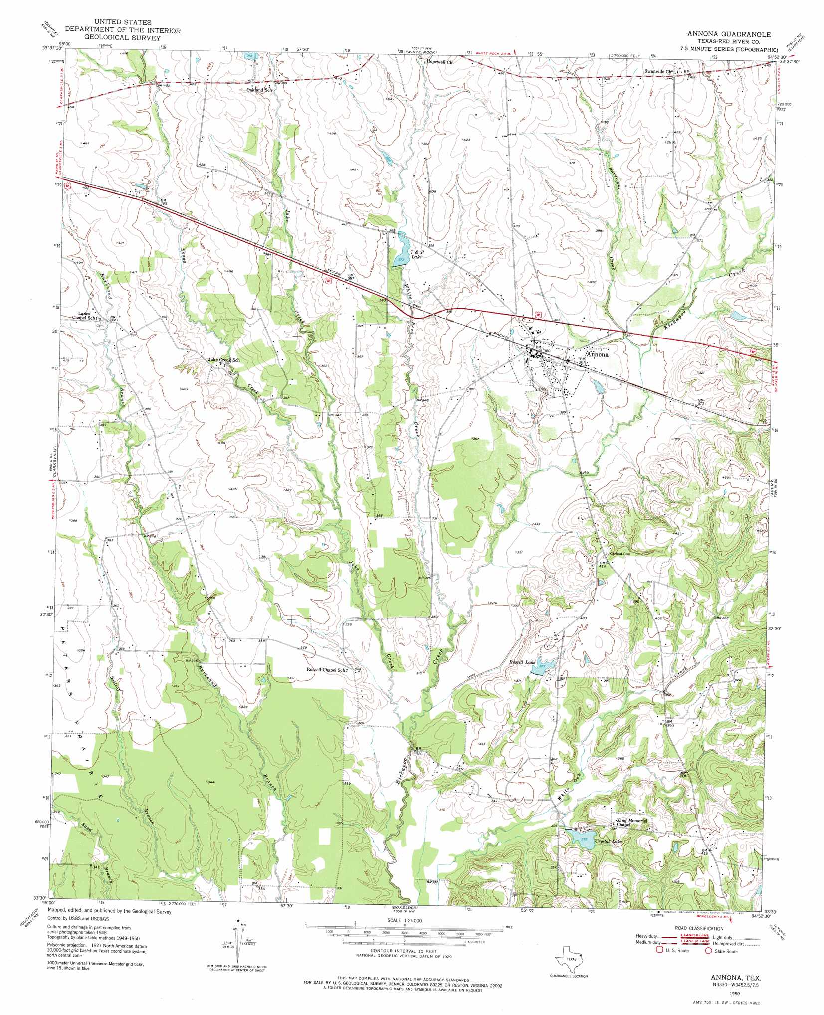
USGS Topo Quad 33094e8 - 1:24,000 scale
| Topo Map Name: | Annona |
| USGS Topo Quad ID: | 33094e8 |
| Print Size: | ca. 21 1/4" wide x 27" high |
| Southeast Coordinates: | 33.5° N latitude / 94.875° W longitude |
| Map Center Coordinates: | 33.5625° N latitude / 94.9375° W longitude |
| U.S. State: | TX |
| Filename: | o33094e8.jpg |
| Download Map JPG Image: | Annona topo map 1:24,000 scale |
| Map Type: | Topographic |
| Topo Series: | 7.5´ |
| Map Scale: | 1:24,000 |
| Source of Map Images: | United States Geological Survey (USGS) |
| Alternate Map Versions: |
Annona TX 1950, updated 1977 Download PDF Buy paper map Annona TX 1951 Download PDF Buy paper map Annona TX 2010 Download PDF Buy paper map Annona TX 2012 Download PDF Buy paper map Annona TX 2016 Download PDF Buy paper map |
1:24,000 Topo Quads surrounding Annona
Manchester |
Negley |
Acworth |
Idabel Se |
Haworth |
Bagwell |
Dimple |
White Rock |
English |
De Kalb Nw |
Line Branch |
Clarksville |
Annona |
Avery |
Oak Grove |
Bogata |
Cuthand |
Boxelder |
Lydia |
Hodgson |
Hagansport |
Talco |
Wilkinson |
Coopers Chapel |
Dalby Springs |
> Back to 33094e1 at 1:100,000 scale
> Back to 33094a1 at 1:250,000 scale
> Back to U.S. Topo Maps home
Annona topo map: Gazetteer
Annona: Airports
Russells Ranch Airport elevation 121m 396′Annona: Dams
Bentsen Lake Dam elevation 128m 419′Crystal Lake Dam elevation 101m 331′
Harvey Lake Dam elevation 103m 337′
Russell Lake 2 Dam elevation 104m 341′
Annona: Flats
Peters Prairie elevation 111m 364′Annona: Populated Places
Annona elevation 114m 374′Mena (historical) elevation 118m 387′
Annona: Reservoirs
Bentsen Lake elevation 128m 419′Crystal Lake elevation 101m 331′
Harvey Lake elevation 103m 337′
Russell Lake elevation 114m 374′
Russell Lake 2 elevation 104m 341′
T and P Lake elevation 113m 370′
Annona: Streams
Hurricane Creek elevation 105m 344′Jake Creek elevation 91m 298′
White Rock Creek elevation 94m 308′
Annona digital topo map on disk
Buy this Annona topo map showing relief, roads, GPS coordinates and other geographical features, as a high-resolution digital map file on DVD: