Melena Topo Map New Mexico
To zoom in, hover over the map of Melena
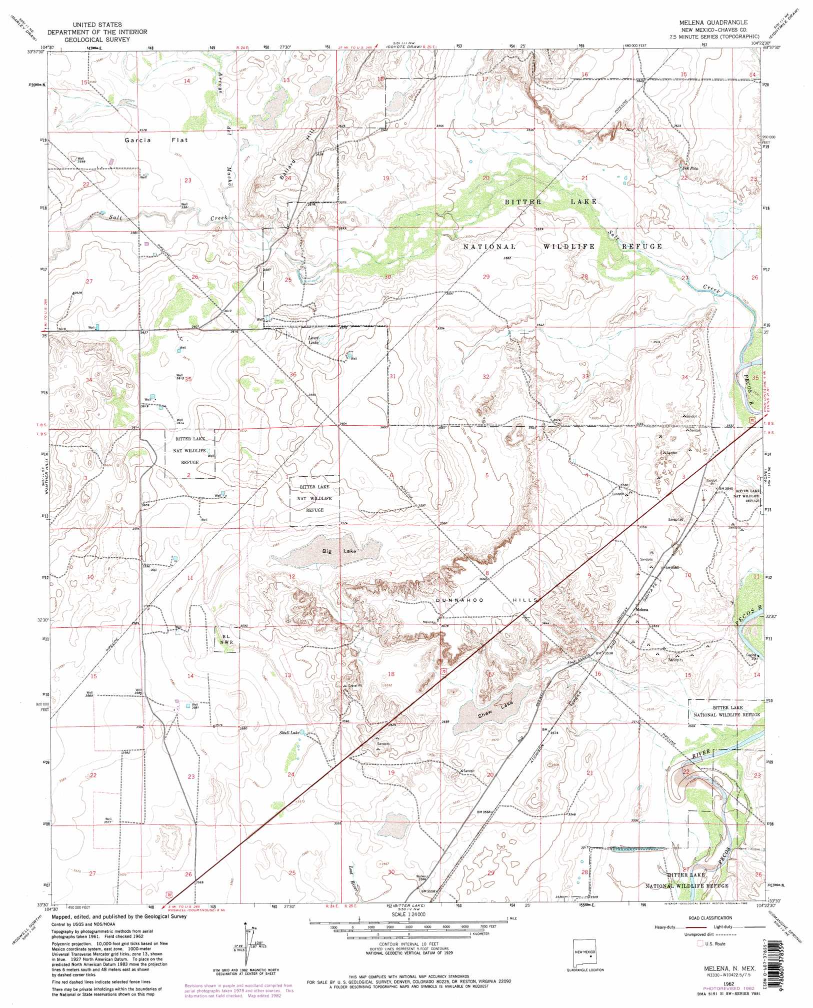
USGS Topo Quad 33104e4 - 1:24,000 scale
| Topo Map Name: | Melena |
| USGS Topo Quad ID: | 33104e4 |
| Print Size: | ca. 21 1/4" wide x 27" high |
| Southeast Coordinates: | 33.5° N latitude / 104.375° W longitude |
| Map Center Coordinates: | 33.5625° N latitude / 104.4375° W longitude |
| U.S. State: | NM |
| Filename: | o33104e4.jpg |
| Download Map JPG Image: | Melena topo map 1:24,000 scale |
| Map Type: | Topographic |
| Topo Series: | 7.5´ |
| Map Scale: | 1:24,000 |
| Source of Map Images: | United States Geological Survey (USGS) |
| Alternate Map Versions: |
Melena NM 1962, updated 1965 Download PDF Buy paper map Melena NM 1962, updated 1982 Download PDF Buy paper map Melena NM 2010 Download PDF Buy paper map Melena NM 2013 Download PDF Buy paper map Melena NM 2017 Download PDF Buy paper map |
1:24,000 Topo Quads surrounding Melena
Mesa Sw |
Mesa Se |
Shannon Draw |
Cottonwood Draw |
Haystack Butte |
Rock House Canyon |
Marley Draw |
Coyote Draw |
Eightmile Draw |
Haystack Mountain |
Barn Draw |
Panther Hill |
Melena |
Acme |
Campbell |
Corn Ranch |
Roswell North |
Bitter Lake |
Comanche Spring |
L E Ranch |
Hondo Reservoir |
Roswell South |
South Spring |
Bottomless Lakes |
Wade Ranch |
> Back to 33104e1 at 1:100,000 scale
> Back to 33104a1 at 1:250,000 scale
> Back to U.S. Topo Maps home
Melena topo map: Gazetteer
Melena: Areas
Dunnahoo Hills elevation 1115m 3658′Melena: Flats
Garcia Flat elevation 1091m 3579′Melena: Lakes
Big Lake elevation 1083m 3553′Ink Pots elevation 1081m 3546′
Lowe Lake elevation 1088m 3569′
Shaw Lake elevation 1083m 3553′
Skull Lake elevation 1085m 3559′
Melena: Mines
Beavers Pit elevation 1087m 3566′Opal Garren Claims elevation 1079m 3540′
Melena: Parks
Bitter Lake National Wildlife Refuge elevation 1079m 3540′Melena: Populated Places
Melena elevation 1086m 3562′Melena: Ridges
Ballard Hill elevation 1121m 3677′Melena: Streams
Arroyo del Macho elevation 1089m 3572′Salt Creek elevation 1073m 3520′
Melena digital topo map on disk
Buy this Melena topo map showing relief, roads, GPS coordinates and other geographical features, as a high-resolution digital map file on DVD: