Six Mile Topo Map South Carolina
To zoom in, hover over the map of Six Mile
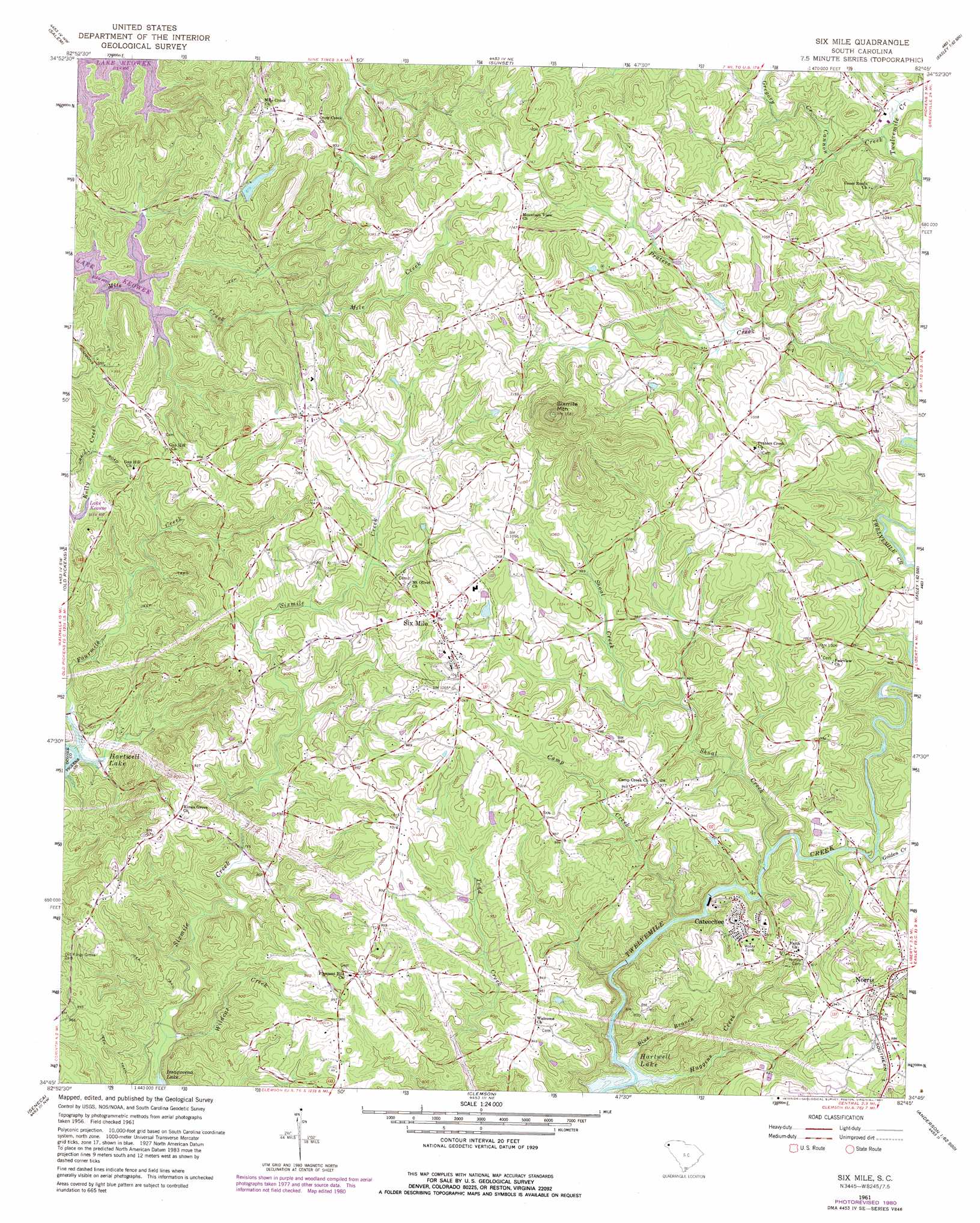
USGS Topo Quad 34082g7 - 1:24,000 scale
| Topo Map Name: | Six Mile |
| USGS Topo Quad ID: | 34082g7 |
| Print Size: | ca. 21 1/4" wide x 27" high |
| Southeast Coordinates: | 34.75° N latitude / 82.75° W longitude |
| Map Center Coordinates: | 34.8125° N latitude / 82.8125° W longitude |
| U.S. State: | SC |
| Filename: | o34082g7.jpg |
| Download Map JPG Image: | Six Mile topo map 1:24,000 scale |
| Map Type: | Topographic |
| Topo Series: | 7.5´ |
| Map Scale: | 1:24,000 |
| Source of Map Images: | United States Geological Survey (USGS) |
| Alternate Map Versions: |
Six Mile SC 1961, updated 1964 Download PDF Buy paper map Six Mile SC 1961, updated 1976 Download PDF Buy paper map Six Mile SC 1961, updated 1981 Download PDF Buy paper map Six Mile SC 2011 Download PDF Buy paper map Six Mile SC 2014 Download PDF Buy paper map |
1:24,000 Topo Quads surrounding Six Mile
Cashiers |
Reid |
Eastatoe Gap |
Table Rock |
Cleveland |
Tamassee |
Salem |
Sunset |
Pickens |
Dacusville |
Walhalla |
Old Pickens |
Six Mile |
Liberty |
Easley |
Westminster |
Seneca |
Clemson |
Five Forks |
Piercetown |
Oakway |
Fair Play |
La France |
Anderson North |
Belton West |
> Back to 34082e1 at 1:100,000 scale
> Back to 34082a1 at 1:250,000 scale
> Back to U.S. Topo Maps home
Six Mile topo map: Gazetteer
Six Mile: Airports
Oakview Airport elevation 323m 1059′Six Mile: Bridges
Lay Bridge (historical) elevation 198m 649′Six Mile: Dams
Mcjunkins Pond Dam D-1963 elevation 297m 974′Praters Creek Dam elevation 288m 944′
South Carolina Noname 39019 D-1971 Dam elevation 268m 879′
Six Mile: Populated Places
Cateechee elevation 279m 915′Norris elevation 306m 1003′
Pearidge elevation 326m 1069′
Six Mile elevation 312m 1023′
Terrapin Crossroads elevation 324m 1062′
Six Mile: Reservoirs
Ile Creek Lake elevation 268m 879′Mcjunkins Pond elevation 297m 974′
Praters Creek Pond elevation 288m 944′
Six Mile: Streams
Blue Branch elevation 199m 652′Camp Creek elevation 222m 728′
Cannon Creek elevation 268m 879′
Fourmile Creek elevation 201m 659′
Golden Creek elevation 244m 800′
Gregory Creek elevation 273m 895′
Huggins Creek elevation 200m 656′
Shoal Creek elevation 241m 790′
Wildcat Creek elevation 209m 685′
Six Mile: Summits
Sixmile Mountain elevation 484m 1587′Six Mile digital topo map on disk
Buy this Six Mile topo map showing relief, roads, GPS coordinates and other geographical features, as a high-resolution digital map file on DVD:
South Carolina, Western North Carolina & Northeastern Georgia
Buy digital topo maps: South Carolina, Western North Carolina & Northeastern Georgia