Leesburg Topo Map Alabama
To zoom in, hover over the map of Leesburg
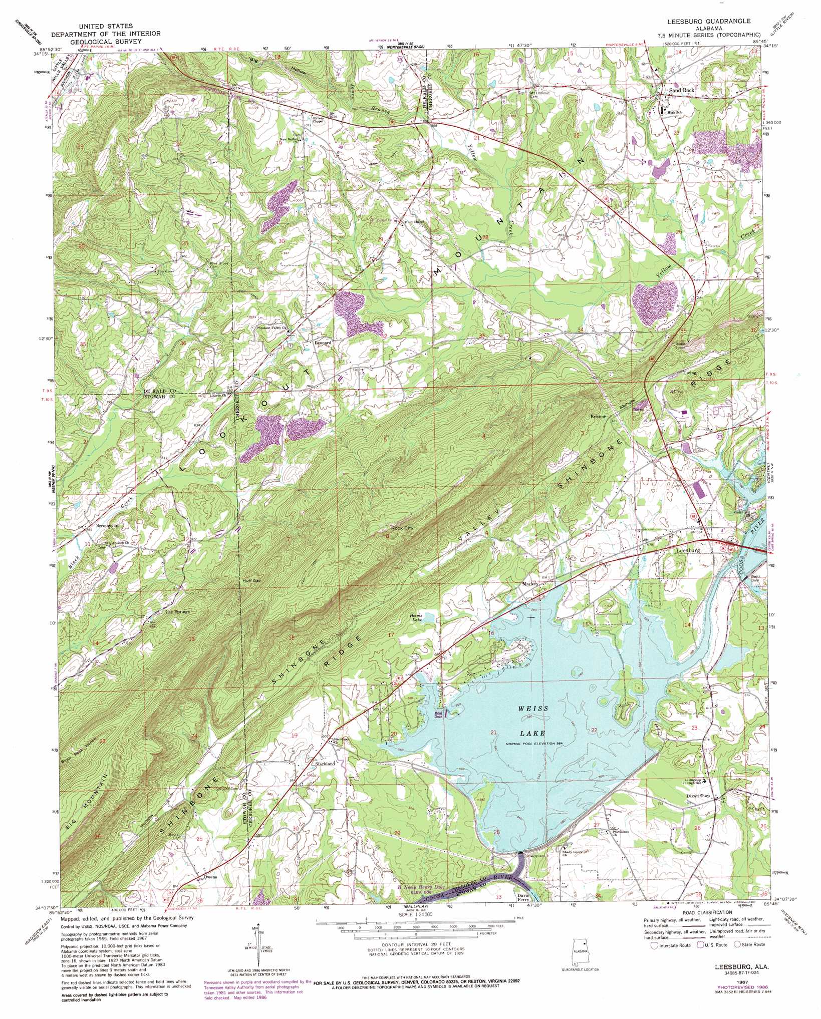
USGS Topo Quad 34085b7 - 1:24,000 scale
| Topo Map Name: | Leesburg |
| USGS Topo Quad ID: | 34085b7 |
| Print Size: | ca. 21 1/4" wide x 27" high |
| Southeast Coordinates: | 34.125° N latitude / 85.75° W longitude |
| Map Center Coordinates: | 34.1875° N latitude / 85.8125° W longitude |
| U.S. State: | AL |
| Filename: | o34085b7.jpg |
| Download Map JPG Image: | Leesburg topo map 1:24,000 scale |
| Map Type: | Topographic |
| Topo Series: | 7.5´ |
| Map Scale: | 1:24,000 |
| Source of Map Images: | United States Geological Survey (USGS) |
| Alternate Map Versions: |
Leesburg AL 1967, updated 1970 Download PDF Buy paper map Leesburg AL 1967, updated 1977 Download PDF Buy paper map Leesburg AL 1967, updated 1987 Download PDF Buy paper map Leesburg AL 2011 Download PDF Buy paper map Leesburg AL 2014 Download PDF Buy paper map |
1:24,000 Topo Quads surrounding Leesburg
Grove Oak |
Fyffe |
Chavies |
Fort Payne |
Jamestown |
Painter |
Crossville |
Portersville |
Little River |
Gaylesville |
Rodentown |
Keener |
Leesburg |
Centre |
Cedar Bluff |
Gadsden West |
Gadsden East |
Ballplay |
Weisner Mountain |
Ellisville |
Dunaway Mountain |
Glencoe |
Colvin Gap |
Piedmont Nw |
Piedmont |
> Back to 34085a1 at 1:100,000 scale
> Back to 34084a1 at 1:250,000 scale
> Back to U.S. Topo Maps home
Leesburg topo map: Gazetteer
Leesburg: Bays
Tillery Cove elevation 172m 564′Leesburg: Crossings
Davis Ferry (historical) elevation 156m 511′Hamptons Ferry (historical) elevation 158m 518′
Tripp Ferry (historical) elevation 178m 583′
Leesburg: Dams
Weiss Dam elevation 176m 577′Leesburg: Gaps
Huff Gap elevation 316m 1036′Leesburg: Islands
Byrams Island elevation 173m 567′Leesburg: Levees
Weiss Lake Dike elevation 173m 567′Leesburg: Parks
Leesburg Park elevation 178m 583′Little Rock City Park elevation 499m 1637′
Leesburg: Pillars
Rock City elevation 499m 1637′Leesburg: Populated Places
Aubrey Isle elevation 185m 606′Bristow elevation 195m 639′
Dixon Shop elevation 165m 541′
Ewing elevation 202m 662′
Kings Hill (historical) elevation 178m 583′
Lay Springs elevation 254m 833′
Leesburg elevation 178m 583′
Leonard elevation 275m 902′
Lookout Valley Acres elevation 190m 623′
Mackey elevation 181m 593′
Mountain Lake Estates elevation 193m 633′
Owens elevation 168m 551′
Sand Rock elevation 278m 912′
Scrougeout elevation 240m 787′
Slackland elevation 184m 603′
Leesburg: Post Offices
Leesburg Post Office elevation 177m 580′Leesburg: Reservoirs
Helms Lake elevation 184m 603′Weiss Lake elevation 176m 577′
Leesburg: Ridges
Big Mountain elevation 471m 1545′Leesburg: Springs
Bristow Spring elevation 214m 702′Leesburg: Streams
Jones Branch elevation 268m 879′Leesburg: Summits
Bar Hill elevation 190m 623′Leesburg: Valleys
Big Hollow elevation 298m 977′Owl Hollow elevation 166m 544′
Shinbone Valley elevation 208m 682′
Leesburg digital topo map on disk
Buy this Leesburg topo map showing relief, roads, GPS coordinates and other geographical features, as a high-resolution digital map file on DVD: